Bridge Statistics for Brunswick, Maryland (MD)
Condition, Traffic, Stress, Structural Evaluation, Project Costs
- National Bridge Inventory (NBI) Statistics
- 17Number of bridges
- 358ft / 109mTotal length
- $5,645,000Total costs
- 121,954Total average daily traffic
- 7,378Total average daily truck traffic
- National Bridge Inventory (NBI) Registered Bridges for Brunswick
- No street view available for this location
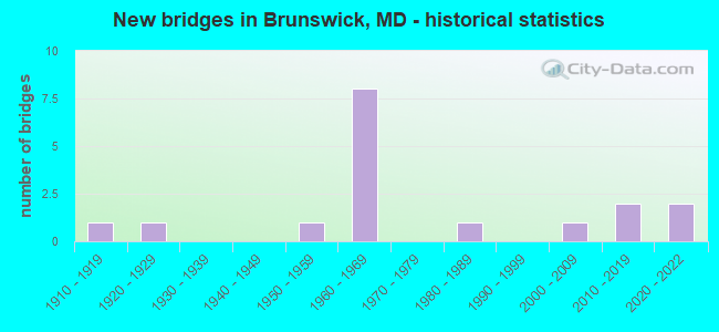
- New bridges - historical statistics
- 11910-1919
- 11920-1929
- 11950-1959
- 81960-1969
- 11980-1989
- 12000-2009
- 22010-2019
- 22020-2022
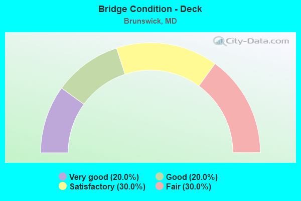
- Bridge Condition - Deck
- 20.0%Very good
- 20.0%Good
- 30.0%Satisfactory
- 30.0%Fair
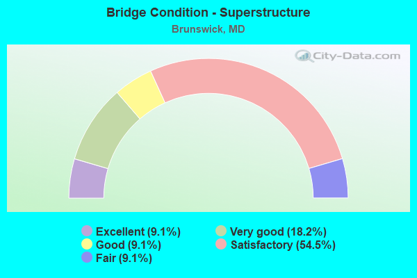
- Bridge Condition - Superstructure
- 9.1%Excellent
- 18.2%Very good
- 9.1%Good
- 54.5%Satisfactory
- 9.1%Fair
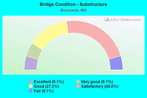
- Bridge Condition - Substructure
- 9.1%Excellent
- 9.1%Very good
- 27.3%Good
- 45.5%Satisfactory
- 9.1%Fair
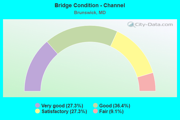
- Bridge Condition - Channel
- 27.3%Very good
- 36.4%Good
- 27.3%Satisfactory
- 9.1%Fair
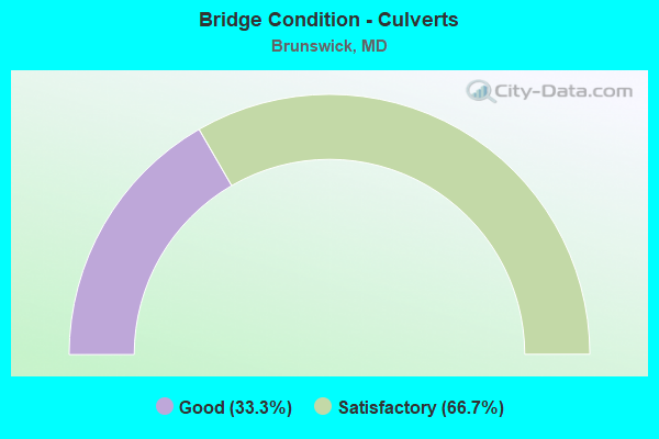
- Bridge Condition - Culverts
- 33.3%Good
- 66.7%Satisfactory
Find on map >> Show street view
Structure Number: 10000010002401, Location: ON VIRGINIA LINE (Lat: 39.307078, Lng: -77.631589), Route carried "on" structure: State highway 17, Year Built: 1953, Status: Open, Structure Length: 74.07m (243.01ft), Average Daily Traffic: 5,525 (year 2017), Truck Traffic: 5%, Average Future Daily Traffic: 8,210 (year 2037), Design Load: H 20, Features Intersected: CSX TRANS., POTOMAC, MUN
Minimum Vertical Clearance: 30+ m (98+ ft), Kilometerpoint: 0.319, Lanes on structure: 2, Lanes under structure: 4, Owner: State Highway Agency, Approaching Roadway Width: 7.9m (25.9ft), Material/Design: Steel continuous, Design/Construction: Girder and Floorbeam System, Number Of Spans In Main Unit: 19, Number Of Approach Spans: 1, Length of Maximum Span: 49.1m (161.1ft), Curb or Sidewalk Widths: Left: 0.9m (3.0ft), Right: 0.9m (3.0ft), Curb-To-Curb Width: 7.9m (25.9ft), Out-to-Out Width: 10.3m (33.8ft)
Condition: Deck: Satisfactory, Superstructure: Satisfactory, Substructure: Satisfactory, Channel: Satisfactory, Operating Rating: 41.3 metric tons, Method Used To Determine Operating Rating: Load Factor (LF), Inventory Rating: 24.5 metric tons, Method Used To Determine Inventory Rating: Load Factor (LF), Structural Evaluation: Equal to present minimum criteria, Deck Geometry: High priority of corrective action, Underclear: High priority of corrective action, Waterway Adequacy: Equal to present desirable criteria, Approach Roadway Alignment: Better than present minimum criteria, Length Of Structure Improvement: 74.07m (243.01ft), Designated Inspection Frequency: Every 24 months, Critical Feature Inspection Frequency: Every 24 months, Underwater Inspection Frequency: Every 48 months, Inspection Date: July 2021, Critical Feature Inspection Date: July 2021, Underwater Inspection Date: August 2021, Bridge Improvement Cost: $4,928,000, Roadway Improvement Cost: $493,000, Total Project Cost: $5,421,000, Deck Structure Type: Concrete Cast-file-Place, Wearing Surface/Protective System: Wearing Surface: Bituminous
Find on map >> Show street view
Structure Number: 10000010008101, Location: 1.31 MILES WEST OF MD 79 (Lat: 39.341269, Lng: -77.634172), Route carried "on" structure: State highway 180, Year Built: 1912, Year Reconstructed: 1932, Status: Open, Structure Length: 0.76m (2.49ft), Average Daily Traffic: 1,300 (year 2009), Truck Traffic: 8%, Average Future Daily Traffic: 1,533 (year 2026), Features Intersected: LITTLE CATOCTIN CREEK
Minimum Vertical Clearance: 30+ m (98+ ft), Kilometerpoint: 4.023, Lanes on structure: 2, Owner: State Highway Agency, Approaching Roadway Width: 9.4m (30.8ft), Skew: 3 degrees, Material/Design: Concrete, Design/Construction: Tee Beam, Number Of Spans In Main Unit: 1, Length of Maximum Span: 6.1m (20.0ft), Curb-To-Curb Width: 8.7m (28.5ft), Out-to-Out Width: 9.3m (30.5ft)
Condition: Deck: Fair, Superstructure: Satisfactory, Substructure: Fair, Channel: Fair, Operating Rating: 75.7 metric tons, Method Used To Determine Operating Rating: Load Factor (LF), Inventory Rating: 45.4 metric tons, Method Used To Determine Inventory Rating: Load Factor (LF), Structural Evaluation: Somewhat better than minimum adequacy, Deck Geometry: Somewhat better than minimum adequacy, Waterway Adequacy: Superior to present desirable criteria, Approach Roadway Alignment: Equal to present desirable criteria, Length Of Structure Improvement: 0.76m (2.49ft), Designated Inspection Frequency: Every 24 months, Inspection Date: November 2020, Bridge Improvement Cost: $46,000, Roadway Improvement Cost: $5,000, Total Project Cost: $51,000, Deck Structure Type: Concrete Cast-file-Place, Wearing Surface/Protective System: Wearing Surface: Bituminous
Find on map >> Show street view
Structure Number: 10000010008801, Location: 0.23 MILE EAST OF MD 180 (Lat: 39.325078, Lng: -77.662347), Route carried "on" structure: State highway 478, Year Built: 1926, Status: Open, Structure Length: 0.79m (2.59ft), Average Daily Traffic: 2,471 (year 2009), Truck Traffic: 8%, Average Future Daily Traffic: 3,506 (year 2026), Features Intersected: BR OF POTOMAC RIVER
Minimum Vertical Clearance: 30+ m (98+ ft), Kilometerpoint: 0.370, Lanes on structure: 2, Owner: State Highway Agency, Approaching Roadway Width: 7.0m (23.0ft), Skew: 1 degrees, Material/Design: Concrete, Design/Construction: Tee Beam, Number Of Spans In Main Unit: 1, Length of Maximum Span: 7.3m (24.0ft), Curb-To-Curb Width: 7.2m (23.6ft), Out-to-Out Width: 7.9m (25.9ft)
Condition: Deck: Fair, Superstructure: Fair, Substructure: Satisfactory, Channel: Satisfactory, Operating Rating: 44.0 metric tons, Method Used To Determine Operating Rating: Allowable Stress (AS), Inventory Rating: 26.3 metric tons, Method Used To Determine Inventory Rating: Allowable Stress (AS), Structural Evaluation: Somewhat better than minimum adequacy, Deck Geometry: High priority of replacement, Waterway Adequacy: Superior to present desirable criteria, Approach Roadway Alignment: Equal to present minimum criteria, Length Of Structure Improvement: 0.79m (2.59ft), Designated Inspection Frequency: Every 12 months, Inspection Date: September 2021, Bridge Improvement Cost: $40,000, Roadway Improvement Cost: $4,000, Total Project Cost: $44,000, Deck Structure Type: Concrete Cast-file-Place, Wearing Surface/Protective System: Wearing Surface: Bituminous
Find on map >> Show street view
Structure Number: 10000010008901, Location: 1.78 MI S. EAST OF MD 180 (Lat: 39.315125, Lng: -77.636903), Route carried "on" structure: State highway 478, Year Built: 2019, Status: Open, Structure Length: 1.78m (5.84ft), Average Daily Traffic: 2,471 (year 2009), Truck Traffic: 8%, Average Future Daily Traffic: 3,506 (year 2026), Features Intersected: BR OF POTOMAC RIVER
Minimum Vertical Clearance: 30+ m (98+ ft), Kilometerpoint: 2.864, Lanes on structure: 2, Base Highway Network: Yes, Owner: State Highway Agency, Approaching Roadway Width: 9.4m (30.8ft), Skew: 2 degrees, Material/Design: Prestressed concrete, Design/Construction: Slab, Number Of Spans In Main Unit: 1, Length of Maximum Span: 16.8m (55.1ft), Curb or Sidewalk Widths: Left: 0.6m (2.0ft), Right: 2.3m (7.5ft), Curb-To-Curb Width: 9.9m (32.5ft), Out-to-Out Width: 12.8m (42.0ft)
Condition: Deck: Very good, Superstructure: Very good, Substructure: Excellent, Channel: Very good, Operating Rating: 70.7 metric tons, Method Used To Determine Operating Rating: Load Factor (LF), Inventory Rating: 42.6 metric tons, Method Used To Determine Inventory Rating: Load Factor (LF), Structural Evaluation: Equal to present desirable criteria, Deck Geometry: Meets minimum limits, Waterway Adequacy: Superior to present desirable criteria, Approach Roadway Alignment: Equal to present desirable criteria, Length Of Structure Improvement: 1.83m (6.00ft), Designated Inspection Frequency: Every 24 months, Inspection Date: January 2022, Bridge Improvement Cost: $48,000, Roadway Improvement Cost: $5,000, Total Project Cost: $53,000 ( Estimate for 2017), Deck Structure Type: Concrete Cast-file-Place, Wearing Surface/Protective System: Wearing Surface: Monolithic Concrete, Deck Protection: Epoxy Coated Reinforcing
Find on map >> Show street view
Structure Number: 10000010009001, Location: 2.16 MILES EAST OF MD 17 (Lat: 39.323436, Lng: -77.592892), Route carried "on" structure: State highway 464, Year Built: 2020, Status: Open, Structure Length: 3.28m (10.76ft), Average Daily Traffic: 4,400 (year 2017), Truck Traffic: 7%, Average Future Daily Traffic: 7,050 (year 2037), Features Intersected: LITTLE CATOCTIN CREEK
Minimum Vertical Clearance: 30+ m (98+ ft), Kilometerpoint: 3.475, Lanes on structure: 2, Owner: State Highway Agency, Approaching Roadway Width: 7.9m (25.9ft), Skew: 9 degrees, Material/Design: Concrete, Design/Construction: Stringer/Multi-beam, Number Of Spans In Main Unit: 1, Length of Maximum Span: 30.5m (100.1ft), Curb-To-Curb Width: 9.8m (32.2ft), Out-to-Out Width: 10.7m (35.1ft)
Condition: Deck: Very good, Superstructure: Excellent, Substructure: Very good, Channel: Very good, Operating Rating: 82.6 metric tons, Method Used To Determine Operating Rating: Load and Resistance Factor Rating (LRFR) rating reported by rating factor(RF) method using HL-93 loadings, Inventory Rating: 42.1 metric tons, Method Used To Determine Inventory Rating: Load and Resistance Factor Rating (LRFR) rating reported by rating factor(RF) method using HL-93 loadings, Structural Evaluation: Equal to present desirable criteria, Deck Geometry: Meets minimum limits, Waterway Adequacy: Equal to present desirable criteria, Approach Roadway Alignment: Equal to present desirable criteria, Length Of Structure Improvement: 1.34m (4.40ft), Designated Inspection Frequency: Every 24 months, Inspection Date: September 2020, Bridge Improvement Cost: $69,000, Roadway Improvement Cost: $7,000, Total Project Cost: $76,000, Deck Structure Type: Concrete Cast-file-Place, Wearing Surface/Protective System: Wearing Surface: Monolithic Concrete, Deck Protection: Epoxy Coated Reinforcing
Find on map >> Show street view
Structure Number: 10000010009101, Location: 3.17 MILES EAST OF MD 17 (Lat: 39.332017, Lng: -77.579122), Route carried "on" structure: State highway 464, Year Built: 2010, Status: Open, Structure Length: 9.24m (30.31ft), Average Daily Traffic: 4,040 (year 2009), Truck Traffic: 9%, Average Future Daily Traffic: 4,900 (year 2030), Features Intersected: CATOCTIN CREEK
Minimum Vertical Clearance: 30+ m (98+ ft), Kilometerpoint: 5.101, Lanes on structure: 2, Owner: State Highway Agency, Approaching Roadway Width: 11.0m (36.1ft), Material/Design: Prestressed concrete, Design/Construction: Stringer/Multi-beam, Number Of Spans In Main Unit: 3, Length of Maximum Span: 36.6m (120.1ft), Curb-To-Curb Width: 9.8m (32.2ft), Out-to-Out Width: 11.0m (36.1ft)
Condition: Deck: Good, Superstructure: Very good, Substructure: Good, Channel: Good, Operating Rating: 52.2 metric tons, Method Used To Determine Operating Rating: Load and Resistance Factor Rating (LRFR) rating reported by rating factor(RF) method using HL-93 loadings, Inventory Rating: 33.0 metric tons, Method Used To Determine Inventory Rating: Load and Resistance Factor Rating (LRFR) rating reported by rating factor(RF) method using HL-93 loadings, Structural Evaluation: Better than present minimum criteria, Deck Geometry: Meets minimum limits, Waterway Adequacy: Better than present minimum criteria, Approach Roadway Alignment: Equal to present desirable criteria, Designated Inspection Frequency: Every 24 months, Inspection Date: May 2021, Deck Structure Type: Concrete Cast-file-Place, Wearing Surface/Protective System: Wearing Surface: Integral Concrete, Deck Protection: Epoxy Coated Reinforcing
Find on map >> Show street view
Structure Number: 100000100113013, Location: 0.27 MILE EAST OF MD 180 (Lat: 39.330544, Lng: -77.667044), Route carried "on" structure: US 340, Year Built: 1964, Status: Open, Structure Length: 3.75m (12.30ft), Average Daily Traffic: 23,492 (year 2009), Truck Traffic: 8%, Average Future Daily Traffic: 13,958 (year 2026), Design Load: HS 20, Features Intersected: S MOUNTAIN ROAD
Minimum Vertical Clearance: 30+ m (98+ ft), Kilometerpoint: 0.837, Lanes on structure: 2, Lanes under structure: 2, Base Highway Network: Yes, Owner: State Highway Agency, Approaching Roadway Width: 13.4m (44.0ft), Skew: 3 degrees, Material/Design: Steel, Design/Construction: Stringer/Multi-beam, Number Of Spans In Main Unit: 3, Length of Maximum Span: 12.8m (42.0ft), Curb-To-Curb Width: 11.3m (37.1ft), Out-to-Out Width: 12.9m (42.3ft)
Condition: Deck: Satisfactory, Superstructure: Satisfactory, Substructure: Satisfactory, Operating Rating: 84.8 metric tons, Method Used To Determine Operating Rating: Load Factor (LF), Inventory Rating: 50.8 metric tons, Method Used To Determine Inventory Rating: Load Factor (LF), Structural Evaluation: Equal to present minimum criteria, Deck Geometry: Equal to present minimum criteria, Underclear: Meets minimum limits, Approach Roadway Alignment: Equal to present desirable criteria, Designated Inspection Frequency: Every 24 months, Inspection Date: May 2020, Deck Structure Type: Concrete Cast-file-Place, Wearing Surface/Protective System: Wearing Surface: Bituminous
Find on map >> Show street view
Structure Number: 100000100113014, Location: 0.27 MILE EAST OF MD 180 (Lat: 39.330961, Lng: -77.666481), Route carried "on" structure: US 340, Year Built: 1964, Status: Open, Structure Length: 3.14m (10.30ft), Average Daily Traffic: 23,492 (year 2009), Truck Traffic: 8%, Average Future Daily Traffic: 13,958 (year 2026), Design Load: HS 20, Features Intersected: S MOUNTAIN ROAD
Minimum Vertical Clearance: 30+ m (98+ ft), Kilometerpoint: 0.837, Lanes on structure: 2, Lanes under structure: 2, Base Highway Network: Yes, Owner: State Highway Agency, Approaching Roadway Width: 13.4m (44.0ft), Skew: 1 degrees, Material/Design: Steel, Design/Construction: Stringer/Multi-beam, Number Of Spans In Main Unit: 3, Length of Maximum Span: 11.0m (36.1ft), Curb-To-Curb Width: 11.3m (37.1ft), Out-to-Out Width: 12.9m (42.3ft)
Condition: Deck: Satisfactory, Superstructure: Satisfactory, Substructure: Satisfactory, Operating Rating: 63.0 metric tons, Method Used To Determine Operating Rating: Load Factor (LF), Inventory Rating: 37.6 metric tons, Method Used To Determine Inventory Rating: Load Factor (LF), Structural Evaluation: Equal to present minimum criteria, Deck Geometry: Equal to present minimum criteria, Underclear: Meets minimum limits, Approach Roadway Alignment: Equal to present desirable criteria, Designated Inspection Frequency: Every 24 months, Inspection Date: May 2020, Deck Structure Type: Concrete Cast-file-Place, Wearing Surface/Protective System: Wearing Surface: Bituminous
Find on map >> Show street view
Structure Number: 10000010011401, Location: 0.15 MILE NORTH OF MD 180 (Lat: 39.339425, Lng: -77.640203), Route carried "on" structure: State highway 17, Year Built: 1964, Status: Open, Structure Length: 7.19m (23.59ft), Average Daily Traffic: 2,061 (year 2009), Truck Traffic: 8%, Average Future Daily Traffic: 2,595 (year 2026), Design Load: HS 20, Features Intersected: US 340
Minimum Vertical Clearance: 30+ m (98+ ft), Kilometerpoint: 4.344, Lanes on structure: 2, Lanes under structure: 4, Owner: State Highway Agency, Approaching Roadway Width: 9.8m (32.2ft), Skew: 2 degrees, Material/Design: Steel, Design/Construction: Stringer/Multi-beam, Number Of Spans In Main Unit: 4, Length of Maximum Span: 23.8m (78.1ft), Curb or Sidewalk Widths: Left: 0.0m, Right: 1.2m (3.9ft), Curb-To-Curb Width: 9.1m (29.9ft), Out-to-Out Width: 11.4m (37.4ft)
Condition: Deck: Fair, Superstructure: Satisfactory, Substructure: Satisfactory, Operating Rating: 82.1 metric tons, Method Used To Determine Operating Rating: Load Factor (LF), Inventory Rating: 49.0 metric tons, Method Used To Determine Inventory Rating: Load Factor (LF), Structural Evaluation: Equal to present minimum criteria, Deck Geometry: Meets minimum limits, Underclear: Somewhat better than minimum adequacy, Approach Roadway Alignment: Equal to present desirable criteria, Designated Inspection Frequency: Every 24 months, Inspection Date: March 2020, Deck Structure Type: Concrete Cast-file-Place, Wearing Surface/Protective System: Wearing Surface: Bituminous
Find on map >> Show street view
Structure Number: 10000010011502, Location: 0.36 MILE EAST OF MD 17 (Lat: 39.342861, Lng: -77.634978), Route carried "on" structure: US 340, Year Built: 1964, Status: Open, Structure Length: 0.74m (2.43ft), Average Daily Traffic: 24,600 (year 2013), Truck Traffic: 8%, Average Future Daily Traffic: 31,560 (year 2026), Design Load: HS 20, Features Intersected: LITTLE CATOCTIN CREEK
Minimum Vertical Clearance: 30+ m (98+ ft), Kilometerpoint: 3.990, Lanes on structure: 4, Base Highway Network: Yes, Owner: State Highway Agency, Approaching Roadway Width: 43.6m (143.0ft), Skew: 3 degrees, Material/Design: Concrete, Design/Construction: Culvert, Length of Maximum Span: 3.7m (12.1ft)
Condition: Channel: Satisfactory, Culverts: Satisfactory, Structural Evaluation: Equal to present minimum criteria, Waterway Adequacy: Equal to present desirable criteria, Approach Roadway Alignment: Equal to present desirable criteria, Designated Inspection Frequency: Every 24 months, Inspection Date: August 2021
Find on map >> Show street view
Structure Number: 200000F-010803, Location: 1200 FT. S. OF ROUTE 28 (Lat: 39.273025, Lng: -77.524869), Route carried "on" structure: County highway 300, Year Built: 1983, Status: Open, Structure Length: 0.88m (2.89ft), Average Daily Traffic: 153 (year 2009), Truck Traffic: 7%, Average Future Daily Traffic: 184 (year 2032), Design Load: HS 20, Features Intersected: WASHINGTON RUN, Facility Carried by Structure: ROCK HALL ROAD
Minimum Vertical Clearance: 30+ m (98+ ft), Kilometerpoint: 0.000, Lanes on structure: 2, Owner: County Highway Agency, Approaching Roadway Width: 6.1m (20.0ft), Material/Design: Steel, Design/Construction: Culvert, Length of Maximum Span: 0.0m, Curb-To-Curb Width: 7.8m (25.6ft), Out-to-Out Width: 8.4m (27.6ft)
Condition: Channel: Good, Culverts: Good, Inventory Rating: 80.3 metric tons, Method Used To Determine Inventory Rating: Load Factor (LF), Structural Evaluation: Better than present minimum criteria, Deck Geometry: Somewhat better than minimum adequacy, Waterway Adequacy: Equal to present desirable criteria, Approach Roadway Alignment: Equal to present desirable criteria, Designated Inspection Frequency: Every 24 months, Inspection Date: April 2021
Find on map >> Show street view
Structure Number: 200000F-B-0103, Location: 420 FT W OF CENTRAL AVE (Lat: 39.316375, Lng: -77.637956), Route carried "on" structure: City street 17, Year Built: 1962, Status: Open, Structure Length: 0.72m (2.36ft), Average Daily Traffic: 797 (year 2021), Truck Traffic: 3%, Average Future Daily Traffic: 1,196 (year 2041), Features Intersected: LOCAL STREAM, Facility Carried by Structure: BRUNSWICK STREET
Minimum Vertical Clearance: 30+ m (98+ ft), Kilometerpoint: 0.000, Lanes on structure: 2, Owner: Town or Township Highway Agency, Approaching Roadway Width: 7.0m (23.0ft), Skew: 3 degrees, Material/Design: Steel, Design/Construction: Culvert, Length of Maximum Span: 3.4m (11.2ft)
Condition: Channel: Good, Culverts: Satisfactory, Structural Evaluation: Equal to present minimum criteria, Waterway Adequacy: Equal to present minimum criteria, Approach Roadway Alignment: Equal to present desirable criteria, Designated Inspection Frequency: Every 24 months, Inspection Date: May 2021
Find on map >> Show street view
Structure Number: 200000F-PK0201, Location: SOUTH OF MD 180 (Lat: 39.346511, Lng: -77.603850), Route carried "on" structure: Other road , Year Built: 2020, Status: Open, Structure Length: 1.37m (4.49ft), Average Daily Traffic: 200 (year 2020), Truck Traffic: 5%, Average Future Daily Traffic: 300 (year 2040), Design Load: HS 25 or greater, Features Intersected: LOCAL STREAM, Facility Carried by Structure: OTHELLO REGIONAL P
Minimum Vertical Clearance: 30+ m (98+ ft), Kilometerpoint: 0.000, Lanes on structure: 2, Owner: County Highway Agency, Approaching Roadway Width: 7.3m (24.0ft), Skew: 3 degrees, Material/Design: Concrete, Design/Construction: Slab, Number Of Spans In Main Unit: 1, Length of Maximum Span: 7.3m (24.0ft), Curb-To-Curb Width: 12.2m (40.0ft), Out-to-Out Width: 13.0m (42.7ft)
Condition: Deck: Good, Superstructure: Good, Substructure: Good, Channel: Very good, Operating Rating: 61.6 metric tons, Method Used To Determine Operating Rating: Load and Resistance Factor Rating (LRFR) rating reported by rating factor(RF) method using HL-93 loadings, Inventory Rating: 47.3 metric tons, Method Used To Determine Inventory Rating: Load and Resistance Factor Rating (LRFR) rating reported by rating factor(RF) method using HL-93 loadings, Structural Evaluation: Better than present minimum criteria, Deck Geometry: Superior to present desirable criteria, Waterway Adequacy: Better than present minimum criteria, Approach Roadway Alignment: Equal to present desirable criteria, Length Of Structure Improvement: 1.37m (4.49ft), Designated Inspection Frequency: Every 24 months, Inspection Date: September 2020, Deck Structure Type: Concrete Precast Panels, Wearing Surface/Protective System: Wearing Surface: Bituminous
Find on map >> Show street view
Structure Number: 200000HO026101, Location: 1/8 MI S OF TRIADELPHIA R (Lat: 39.356681, Lng: -77.644908), Route carried "on" structure: County highway , Year Built: 2007, Status: Open, Structure Length: 1.43m (4.69ft), Average Daily Traffic: 50 (year 2016), Average Future Daily Traffic: 50 (year 2037), Features Intersected: UNNAMED STREAM, Facility Carried by Structure: BROCCOLINO WAY
Minimum Vertical Clearance: 30+ m (98+ ft), Kilometerpoint: 0.000, Lanes on structure: 2, Owner: County Highway Agency, Approaching Roadway Width: 7.0m (23.0ft), Material/Design: Steel, Design/Construction: Arch - Deck, Number Of Spans In Main Unit: 1, Length of Maximum Span: 14.3m (46.9ft), Curb-To-Curb Width: 8.2m (26.9ft), Out-to-Out Width: 9.1m (29.9ft)
Condition: Superstructure: Satisfactory, Substructure: Good, Channel: Good, Operating Rating: 49.0 metric tons, Method Used To Determine Operating Rating: Load Factor (LF), Inventory Rating: 42.2 metric tons, Method Used To Determine Inventory Rating: Load Factor (LF), Structural Evaluation: Equal to present minimum criteria, Deck Geometry: Equal to present minimum criteria, Waterway Adequacy: Equal to present desirable criteria, Approach Roadway Alignment: Equal to present desirable criteria, Designated Inspection Frequency: Every 24 months, Inspection Date: Febuary 2020
Find on map >> Show street view
Structure Number: 100000100113013, Location: 0.27 MI E OF MD 180 (Lat: 39.330544, Lng: -77.667044), Route carried "under" structure: County highway 1637, Year Built: 1964, Structure Length: 0. m, Features Intersected: S MOUNTAIN ROAD, Facility Carried by Structure: US 340 EBR
Minimum Vertical Clearance: 6.10m (20.01ft), Kilometerpoint: 0.257, Lanes on structure: 2, Lanes under structure: 2, Material/Design: Steel, Design/Construction: Stringer/Multi-beam, Length of Maximum Span: 12.8m (42.0ft)
Find on map >> Show street view
Structure Number: 100000100113014, Location: 0.27 MI E OF MD 180 (Lat: 39.330961, Lng: -77.666481), Route carried "under" structure: County highway 1637, Year Built: 1964, Structure Length: 0. m, Features Intersected: S MOUNTAIN ROAD, Facility Carried by Structure: US 340 WBR
Minimum Vertical Clearance: 5.79m (19.00ft), Kilometerpoint: 0.338, Lanes on structure: 2, Lanes under structure: 2, Material/Design: Steel, Design/Construction: Stringer/Multi-beam, Length of Maximum Span: 11.0m (36.1ft)
Find on map >> Show street view
Structure Number: 10000010011401, Location: 1.79 MILES EAST OF MD 180 (Lat: 39.339425, Lng: -77.640203), Route carried "under" structure: US 340, Year Built: 1964, Structure Length: 0. m, Average Daily Traffic: 26,902 (year 2009), Features Intersected: US 340, Facility Carried by Structure: MD 17
Minimum Vertical Clearance: 4.88m (16.01ft), Kilometerpoint: 3.411, Lanes on structure: 2, Lanes under structure: 4, Material/Design: Steel, Design/Construction: Stringer/Multi-beam, Length of Maximum Span: 23.8m (78.1ft)