Bridge Statistics for Concord, New York (NY)
Condition, Traffic, Stress, Structural Evaluation, Project Costs
- National Bridge Inventory (NBI) Statistics
- 34Number of bridges
- 203ft / 61.8mTotal length
- $54,421,000Total costs
- 70,509Total average daily traffic
- 3,865Total average daily truck traffic
- National Bridge Inventory (NBI) Registered Bridges for Concord
- No street view available for this location
- New bridges - historical statistics
- 11920-1929
- 21930-1939
- 21950-1959
- 31960-1969
- 21970-1979
- 131980-1989
- 51990-1999
- 22000-2009
- 42010-2019
- Bridge Condition - Deck
- 15.4%Very good
- 38.5%Good
- 7.7%Satisfactory
- 23.1%Fair
- 7.7%Poor
- 7.7%Serious
- Bridge Condition - Superstructure
- 7.7%Excellent
- 30.8%Very good
- 30.8%Good
- 7.7%Satisfactory
- 7.7%Fair
- 7.7%Poor
- 7.7%Serious
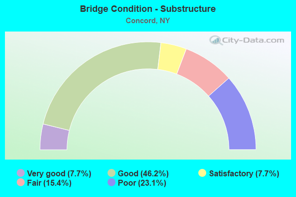
- Bridge Condition - Substructure
- 7.7%Very good
- 46.2%Good
- 7.7%Satisfactory
- 15.4%Fair
- 23.1%Poor
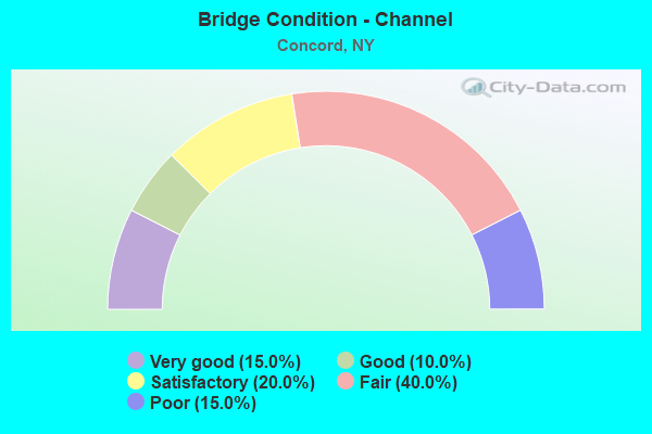
- Bridge Condition - Channel
- 15.0%Very good
- 10.0%Good
- 20.0%Satisfactory
- 40.0%Fair
- 15.0%Poor
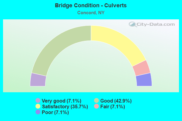
- Bridge Condition - Culverts
- 7.1%Very good
- 42.9%Good
- 35.7%Satisfactory
- 7.1%Fair
- 7.1%Poor
Find on map >> Show street view
Structure Number: 10245, Location: 1.1 MI W JCT RTS 39 + 219 (Lat: 42.508156, Lng: -78.706667), Route carried "on" structure: State highway 39, Year Built: 1970, Status: Open, Structure Length: 1.10m (3.61ft), Average Daily Traffic: 3,602 (year 2017), Truck Traffic: 11%, Average Future Daily Traffic: 3,799 (year 2040), Design Load: HS 20, Features Intersected: SPOONER CREEK
Minimum Vertical Clearance: 30+ m (98+ ft), Kilometerpoint: 23.395, Lanes on structure: 2, Base Highway Network: Yes, Owner: State Highway Agency, Approaching Roadway Width: 12.2m (40.0ft), Skew: 3 degrees, Material/Design: Concrete continuous, Design/Construction: Culvert, Number Of Spans In Main Unit: 2, Length of Maximum Span: 4.5m (14.8ft), Curb or Sidewalk Widths: Left: 0.3m (1.0ft), Right: 0.3m (1.0ft)
Condition: Channel: Very good, Culverts: Satisfactory, Operating Rating: 75.8 metric tons, Method Used To Determine Operating Rating: Field evaluation and documented engineering judgment, Inventory Rating: 32.7 metric tons, Method Used To Determine Inventory Rating: Field evaluation and documented engineering judgment, Structural Evaluation: Equal to present minimum criteria, Waterway Adequacy: Equal to present desirable criteria, Approach Roadway Alignment: Better than present minimum criteria, Length Of Structure Improvement: 1.09m (3.58ft), Designated Inspection Frequency: Every 24 months, Inspection Date: April 2020, Bridge Improvement Cost: $370,000, Roadway Improvement Cost: $216,000, Total Project Cost: $586,000 ( Estimate for 2021), Wearing Surface/Protective System: Wearing Surface: Bituminous
Find on map >> Show street view
Structure Number: 10416, Location: 5.8 MI N JCT US219 & SH39 (Lat: 42.579325, Lng: -78.695317), Route carried "on" structure: County highway , Year Built: 1999, Status: Open, Structure Length: 1.16m (3.81ft), Average Daily Traffic: 1,236 (year 2017), Truck Traffic: 6%, Average Future Daily Traffic: 1,248 (year 2040), Design Load: HS 25 or greater, Features Intersected: EIGHTEEN MILE CRK, Facility Carried by Structure: SPRVLLE-BOSTON RD
Minimum Vertical Clearance: 30+ m (98+ ft), Kilometerpoint: 10.732, Lanes on structure: 2, Owner: County Highway Agency, Approaching Roadway Width: 10.4m (34.1ft), Skew: 1 degrees, Material/Design: Concrete, Design/Construction: Culvert, Number Of Spans In Main Unit: 1, Length of Maximum Span: 11.2m (36.7ft)
Condition: Channel: Fair, Culverts: Very good, Operating Rating: 78.0 metric tons, Method Used To Determine Operating Rating: Load Factor (LF), Inventory Rating: 46.3 metric tons, Method Used To Determine Inventory Rating: Load Factor (LF), Structural Evaluation: Equal to present desirable criteria, Waterway Adequacy: Meets minimum limits, Approach Roadway Alignment: Equal to present minimum criteria, Length Of Structure Improvement: 1.15m (3.77ft), Designated Inspection Frequency: Every 24 months, Inspection Date: July 2021, Bridge Improvement Cost: $332,000, Roadway Improvement Cost: $194,000, Total Project Cost: $526,000 ( Estimate for 2021)
Find on map >> Show street view
Structure Number: 104161, Location: 6.7 MI N JCT US219 & SH39 (Lat: 42.590019, Lng: -78.704233), Route carried "on" structure: County highway , Year Built: 1989, Status: Open, Structure Length: 1.16m (3.81ft), Average Daily Traffic: 1,236 (year 2017), Truck Traffic: 6%, Average Future Daily Traffic: 1,248 (year 2040), Design Load: HS 20, Features Intersected: EIGHTEEN MILE CRK, Facility Carried by Structure: SPRINGN'LE-BOSTON
Minimum Vertical Clearance: 30+ m (98+ ft), Kilometerpoint: 12.196, Lanes on structure: 2, Owner: County Highway Agency, Approaching Roadway Width: 7.3m (24.0ft), Material/Design: Concrete, Design/Construction: Culvert, Number Of Spans In Main Unit: 1, Length of Maximum Span: 10.3m (33.8ft)
Condition: Channel: Fair, Culverts: Good, Operating Rating: 79.9 metric tons, Method Used To Determine Operating Rating: Field evaluation and documented engineering judgment, Inventory Rating: 32.7 metric tons, Method Used To Determine Inventory Rating: Field evaluation and documented engineering judgment, Structural Evaluation: Better than present minimum criteria, Waterway Adequacy: Equal to present desirable criteria, Approach Roadway Alignment: Equal to present desirable criteria, Length Of Structure Improvement: 1.15m (3.77ft), Designated Inspection Frequency: Every 24 months, Inspection Date: May 2020, Bridge Improvement Cost: $234,000, Roadway Improvement Cost: $137,000, Total Project Cost: $371,000 ( Estimate for 2021), Wearing Surface/Protective System: Wearing Surface: Bituminous
Find on map >> Show street view
Structure Number: 1071071, Location: 7.4MI N JCT.RTES 219 & 39 (Lat: 42.604300, Lng: -78.753014), Route carried "on" structure: US 219, Year Built: 1981, Status: Open, Structure Length: 2.99m (9.81ft), Average Daily Traffic: 5,706 (year 2019), Truck Traffic: 7%, Average Future Daily Traffic: 8,904 (year 2040), Design Load: HS 20, Features Intersected: BROWN HILL ROAD
Minimum Vertical Clearance: 30+ m (98+ ft), Kilometerpoint: 16.251, Lanes on structure: 2, Lanes under structure: 2, Base Highway Network: Yes, Owner: State Highway Agency, Approaching Roadway Width: 11.6m (38.1ft), Skew: 2 degrees, Material/Design: Steel, Design/Construction: Stringer/Multi-beam, Number Of Spans In Main Unit: 1, Length of Maximum Span: 28.9m (94.8ft), Curb-To-Curb Width: 12.5m (41.0ft), Out-to-Out Width: 13.4m (44.0ft)
Condition: Deck: Good, Superstructure: Good, Substructure: Good, Operating Rating: 46.0 metric tons, Method Used To Determine Operating Rating: Load and Resistance Factor Rating (LRFR) rating reported by rating factor(RF) method using HL-93 loadings, Inventory Rating: 35.6 metric tons, Method Used To Determine Inventory Rating: Load and Resistance Factor Rating (LRFR) rating reported by rating factor(RF) method using HL-93 loadings, Structural Evaluation: Better than present minimum criteria, Deck Geometry: Better than present minimum criteria, Underclear: Equal to present minimum criteria, Approach Roadway Alignment: Equal to present desirable criteria, Length Of Structure Improvement: 2.98m (9.78ft), Designated Inspection Frequency: Every 24 months, Inspection Date: August 2021, Bridge Improvement Cost: $2,403,000, Roadway Improvement Cost: $1,407,000, Total Project Cost: $3,810,000 ( Estimate for 2021), Deck Structure Type: Concrete Cast-file-Place, Wearing Surface/Protective System: Wearing Surface: Epoxy Overlay, Deck Protection: Epoxy Coated Reinforcing
Find on map >> Show street view
Structure Number: 1071072, Location: 2.4 MI NE OF NEW OREGON (Lat: 42.604447, Lng: -78.752108), Route carried "on" structure: US 219, Year Built: 1981, Status: Open, Structure Length: 2.99m (9.81ft), Average Daily Traffic: 5,706 (year 2019), Truck Traffic: 7%, Average Future Daily Traffic: 8,904 (year 2040), Design Load: HS 20, Features Intersected: BROWN HILL ROAD
Minimum Vertical Clearance: 30+ m (98+ ft), Kilometerpoint: 16.251, Lanes on structure: 2, Lanes under structure: 2, Base Highway Network: Yes, Owner: State Highway Agency, Approaching Roadway Width: 11.6m (38.1ft), Skew: 2 degrees, Material/Design: Steel, Design/Construction: Stringer/Multi-beam, Number Of Spans In Main Unit: 1, Length of Maximum Span: 28.9m (94.8ft), Curb-To-Curb Width: 12.5m (41.0ft), Out-to-Out Width: 13.4m (44.0ft)
Condition: Deck: Good, Superstructure: Good, Substructure: Good, Operating Rating: 45.7 metric tons, Method Used To Determine Operating Rating: Load and Resistance Factor Rating (LRFR) rating reported by rating factor(RF) method using HL-93 loadings, Inventory Rating: 35.3 metric tons, Method Used To Determine Inventory Rating: Load and Resistance Factor Rating (LRFR) rating reported by rating factor(RF) method using HL-93 loadings, Structural Evaluation: Better than present minimum criteria, Deck Geometry: Better than present minimum criteria, Underclear: Equal to present minimum criteria, Approach Roadway Alignment: Equal to present desirable criteria, Length Of Structure Improvement: 2.98m (9.78ft), Designated Inspection Frequency: Every 24 months, Inspection Date: August 2021, Bridge Improvement Cost: $2,403,000, Roadway Improvement Cost: $1,407,000, Total Project Cost: $3,810,000 ( Estimate for 2021), Deck Structure Type: Concrete Cast-file-Place, Wearing Surface/Protective System: Wearing Surface: Epoxy Overlay, Deck Protection: Epoxy Coated Reinforcing
Find on map >> Show street view
Structure Number: 1071081, Location: 6.3MI N JCT RTES 219 & 39 (Lat: 42.590208, Lng: -78.737914), Route carried "on" structure: US 219, Year Built: 1981, Status: Open, Structure Length: 2.83m (9.28ft), Average Daily Traffic: 5,706 (year 2019), Truck Traffic: 7%, Average Future Daily Traffic: 8,904 (year 2040), Design Load: HS 20, Features Intersected: TREVETT RD CR420
Minimum Vertical Clearance: 30+ m (98+ ft), Kilometerpoint: 14.320, Lanes on structure: 2, Lanes under structure: 2, Base Highway Network: Yes, Owner: State Highway Agency, Approaching Roadway Width: 12.8m (42.0ft), Skew: 1 degrees, Material/Design: Steel, Design/Construction: Stringer/Multi-beam, Number Of Spans In Main Unit: 1, Length of Maximum Span: 27.4m (89.9ft), Curb-To-Curb Width: 12.5m (41.0ft), Out-to-Out Width: 13.4m (44.0ft)
Condition: Deck: Good, Superstructure: Good, Substructure: Good, Operating Rating: 63.2 metric tons, Method Used To Determine Operating Rating: Load and Resistance Factor Rating (LRFR) rating reported by rating factor(RF) method using HL-93 loadings, Inventory Rating: 48.6 metric tons, Method Used To Determine Inventory Rating: Load and Resistance Factor Rating (LRFR) rating reported by rating factor(RF) method using HL-93 loadings, Structural Evaluation: Better than present minimum criteria, Deck Geometry: Better than present minimum criteria, Underclear: Equal to present minimum criteria, Approach Roadway Alignment: Equal to present desirable criteria, Length Of Structure Improvement: 2.83m (9.28ft), Designated Inspection Frequency: Every 24 months, Inspection Date: October 2021, Bridge Improvement Cost: $2,176,000, Roadway Improvement Cost: $1,274,000, Total Project Cost: $3,450,000 ( Estimate for 2021), Deck Structure Type: Concrete Cast-file-Place, Wearing Surface/Protective System: Wearing Surface: Epoxy Overlay, Deck Protection: Epoxy Coated Reinforcing
Find on map >> Show street view
Structure Number: 1071082, Location: 6.3MI N JCT RTES 219 & 39 (Lat: 42.590978, Lng: -78.737225), Route carried "on" structure: US 219, Year Built: 1981, Status: Open, Structure Length: 2.83m (9.28ft), Average Daily Traffic: 5,706 (year 2019), Truck Traffic: 7%, Average Future Daily Traffic: 8,904 (year 2040), Design Load: HS 20, Features Intersected: TREVETT ROAD
Minimum Vertical Clearance: 30+ m (98+ ft), Kilometerpoint: 14.320, Lanes on structure: 2, Lanes under structure: 2, Base Highway Network: Yes, Owner: State Highway Agency, Approaching Roadway Width: 12.8m (42.0ft), Skew: 1 degrees, Material/Design: Steel, Design/Construction: Stringer/Multi-beam, Number Of Spans In Main Unit: 1, Length of Maximum Span: 27.4m (89.9ft), Curb-To-Curb Width: 12.5m (41.0ft), Out-to-Out Width: 13.4m (44.0ft)
Condition: Deck: Satisfactory, Superstructure: Satisfactory, Substructure: Good, Operating Rating: 62.9 metric tons, Method Used To Determine Operating Rating: Load and Resistance Factor Rating (LRFR) rating reported by rating factor(RF) method using HL-93 loadings, Inventory Rating: 48.3 metric tons, Method Used To Determine Inventory Rating: Load and Resistance Factor Rating (LRFR) rating reported by rating factor(RF) method using HL-93 loadings, Structural Evaluation: Equal to present minimum criteria, Deck Geometry: Better than present minimum criteria, Underclear: Superior to present desirable criteria, Approach Roadway Alignment: Equal to present desirable criteria, Length Of Structure Improvement: 2.83m (9.28ft), Designated Inspection Frequency: Every 24 months, Inspection Date: October 2021, Bridge Improvement Cost: $2,258,000, Roadway Improvement Cost: $1,322,000, Total Project Cost: $3,580,000 ( Estimate for 2021), Deck Structure Type: Concrete Cast-file-Place, Wearing Surface/Protective System: Wearing Surface: Epoxy Overlay, Deck Protection: Epoxy Coated Reinforcing
Find on map >> Show street view
Structure Number: 107109, Location: 3.1 MI N JCT SH39 &S EXPY (Lat: 42.553022, Lng: -78.710856), Route carried "on" structure: Alternate County highway , Year Built: 1981, Status: Open, Structure Length: 9.63m (31.59ft), Average Daily Traffic: 1,259 (year 2017), Truck Traffic: 10%, Average Future Daily Traffic: 1,271 (year 2040), Design Load: HS 20, Features Intersected: 219 219 53121055 NB, RTE, Facility Carried by Structure: GENESEE ROAD
Minimum Vertical Clearance: 30+ m (98+ ft), Kilometerpoint: 4.457, Lanes on structure: 2, Lanes under structure: 4, Owner: State Highway Agency, Approaching Roadway Width: 19.5m (64.0ft), Material/Design: Steel continuous, Design/Construction: Stringer/Multi-beam, Number Of Spans In Main Unit: 3, Length of Maximum Span: 37.4m (122.7ft), Curb-To-Curb Width: 19.2m (63.0ft), Out-to-Out Width: 20.1m (65.9ft)
Condition: Deck: Poor, Superstructure: Very good, Substructure: Poor, Operating Rating: 31.1 metric tons, Method Used To Determine Operating Rating: Load and Resistance Factor Rating (LRFR) rating reported by rating factor(RF) method using HL-93 loadings, Inventory Rating: 24.0 metric tons, Method Used To Determine Inventory Rating: Load and Resistance Factor Rating (LRFR) rating reported by rating factor(RF) method using HL-93 loadings, Structural Evaluation: Meets minimum limits, Deck Geometry: Superior to present desirable criteria, Underclear: Better than present minimum criteria, Approach Roadway Alignment: Equal to present desirable criteria, Length Of Structure Improvement: 9.63m (31.59ft), Designated Inspection Frequency: Every 24 months, Inspection Date: June 2021, Bridge Improvement Cost: $7,893,000, Roadway Improvement Cost: $4,622,000, Total Project Cost: $12,514,000 ( Estimate for 2021), Deck Structure Type: Concrete Cast-file-Place, Wearing Surface/Protective System: Wearing Surface: Integral Concrete, Deck Protection: Epoxy Coated Reinforcing
Find on map >> Show street view
Structure Number: 1078051, Location: SE of Springville (Lat: 42.474578, Lng: -78.696119), Route carried "on" structure: State highway 219, Year Built: 2010, Status: Open, Structure Length: 6.16m (20.21ft), Average Daily Traffic: 2,479 (year 2019), Truck Traffic: 12%, Average Future Daily Traffic: 3,867 (year 2040), Design Load: HL 93, Features Intersected: SOUTH CASCADE DRI
Minimum Vertical Clearance: 30+ m (98+ ft), Kilometerpoint: 0.306, Lanes on structure: 2, Lanes under structure: 2, Base Highway Network: Yes, Owner: State Highway Agency, Approaching Roadway Width: 11.9m (39.0ft), Skew: 5 degrees, Material/Design: Steel, Design/Construction: Stringer/Multi-beam, Number Of Spans In Main Unit: 1, Length of Maximum Span: 58.7m (192.6ft), Curb-To-Curb Width: 12.0m (39.4ft), Out-to-Out Width: 13.0m (42.7ft)
Condition: Deck: Very good, Superstructure: Excellent, Substructure: Good, Operating Rating: 87.1 metric tons, Method Used To Determine Operating Rating: Load Factor (LF), Inventory Rating: 51.7 metric tons, Method Used To Determine Inventory Rating: Load Factor (LF), Structural Evaluation: Better than present minimum criteria, Deck Geometry: Better than present minimum criteria, Underclear: Superior to present desirable criteria, Approach Roadway Alignment: Equal to present desirable criteria, Length Of Structure Improvement: 6.15m (20.18ft), Designated Inspection Frequency: Every 24 months, Inspection Date: August 2020, Bridge Improvement Cost: $3,371,000, Roadway Improvement Cost: $1,974,000, Total Project Cost: $5,345,000 ( Estimate for 2021), Deck Structure Type: Concrete Cast-file-Place, Wearing Surface/Protective System: Wearing Surface: Integral Concrete, Deck Protection: Epoxy Coated Reinforcing
Find on map >> Show street view
Structure Number: 1078052, Location: SW of Springville (Lat: 42.475164, Lng: -78.695650), Route carried "on" structure: US 219, Year Built: 2010, Status: Open, Structure Length: 6.16m (20.21ft), Average Daily Traffic: 2,479 (year 2019), Truck Traffic: 12%, Average Future Daily Traffic: 3,867 (year 2040), Design Load: HL 93, Features Intersected: SOUTH CASCADE DRI
Minimum Vertical Clearance: 30+ m (98+ ft), Kilometerpoint: 0.306, Lanes on structure: 2, Lanes under structure: 2, Base Highway Network: Yes, Owner: State Highway Agency, Approaching Roadway Width: 11.9m (39.0ft), Skew: 5 degrees, Material/Design: Steel, Design/Construction: Stringer/Multi-beam, Number Of Spans In Main Unit: 1, Length of Maximum Span: 58.7m (192.6ft), Curb-To-Curb Width: 12.0m (39.4ft), Out-to-Out Width: 13.0m (42.7ft)
Condition: Deck: Very good, Superstructure: Very good, Substructure: Good, Operating Rating: 87.1 metric tons, Method Used To Determine Operating Rating: Load Factor (LF), Inventory Rating: 51.7 metric tons, Method Used To Determine Inventory Rating: Load Factor (LF), Structural Evaluation: Better than present minimum criteria, Deck Geometry: Better than present minimum criteria, Underclear: Somewhat better than minimum adequacy, Approach Roadway Alignment: Equal to present desirable criteria, Length Of Structure Improvement: 6.15m (20.18ft), Designated Inspection Frequency: Every 24 months, Inspection Date: August 2020, Bridge Improvement Cost: $3,420,000, Roadway Improvement Cost: $2,003,000, Total Project Cost: $5,423,000 ( Estimate for 2021), Deck Structure Type: Concrete Cast-file-Place, Wearing Surface/Protective System: Wearing Surface: Integral Concrete, Deck Protection: Epoxy Coated Reinforcing
Find on map >> Show street view
Structure Number: 226082, Location: .9 MI N OF EAST CONCORD (Lat: 42.564231, Lng: -78.636717), Route carried "on" structure: Other road , Year Built: 2002, Status: Open, Structure Length: 0.76m (2.49ft), Average Daily Traffic: 25 (year 2018), Truck Traffic: 22%, Average Future Daily Traffic: 35 (year 2038), Design Load: HS 25 or greater, Features Intersected: GRAFF BROOK, Facility Carried by Structure: ROSS ROAD
Minimum Vertical Clearance: 30+ m (98+ ft), Kilometerpoint: 0.032, Lanes on structure: 2, Owner: Town or Township Highway Agency, Approaching Roadway Width: 6.1m (20.0ft), Skew: 2 degrees, Material/Design: Steel, Design/Construction: Culvert, Number Of Spans In Main Unit: 2, Length of Maximum Span: 3.3m (10.8ft)
Condition: Channel: Fair, Culverts: Poor, Operating Rating: 73.9 metric tons, Method Used To Determine Operating Rating: Field evaluation and documented engineering judgment, Inventory Rating: 24.5 metric tons, Method Used To Determine Inventory Rating: Field evaluation and documented engineering judgment, Structural Evaluation: Meets minimum limits, Waterway Adequacy: Somewhat better than minimum adequacy, Approach Roadway Alignment: Meets minimum limits, Length Of Structure Improvement: 0.76m (2.49ft), Designated Inspection Frequency: Every 24 months, Inspection Date: October 2020, Bridge Improvement Cost: $128,000, Roadway Improvement Cost: $75,000, Total Project Cost: $204,000 ( Estimate for 2021)
Find on map >> Show street view
Structure Number: 304247, Location: 4.4 MI N JCT SH240 & SH39 (Lat: 42.568872, Lng: -78.641361), Route carried "on" structure: State highway 240, Year Built: 1966, Status: Open, Structure Length: 0.85m (2.79ft), Average Daily Traffic: 1,758 (year 2018), Truck Traffic: 7%, Average Future Daily Traffic: 1,775 (year 2040), Features Intersected: GRAFF BROOK
Minimum Vertical Clearance: 30+ m (98+ ft), Kilometerpoint: 8.415, Lanes on structure: 2, Base Highway Network: Yes, Owner: County Highway Agency, Approaching Roadway Width: 12.2m (40.0ft), Skew: 5 degrees, Material/Design: Steel, Design/Construction: Culvert, Number Of Spans In Main Unit: 3, Length of Maximum Span: 2.1m (6.9ft)
Condition: Channel: Poor, Culverts: Good, Operating Rating: 74.0 metric tons, Method Used To Determine Operating Rating: Field evaluation and documented engineering judgment, Inventory Rating: 32.7 metric tons, Method Used To Determine Inventory Rating: Field evaluation and documented engineering judgment, Structural Evaluation: Better than present minimum criteria, Waterway Adequacy: Meets minimum limits, Approach Roadway Alignment: Equal to present desirable criteria, Length Of Structure Improvement: 0.85m (2.79ft), Designated Inspection Frequency: Every 24 months, Inspection Date: May 2020, Bridge Improvement Cost: $288,000, Roadway Improvement Cost: $168,000, Total Project Cost: $456,000 ( Estimate for 2021), Wearing Surface/Protective System: Wearing Surface: Bituminous
Find on map >> Show street view
Structure Number: 304248, Location: 5.4 MI N JCT SH240 & SH39 (Lat: 42.574825, Lng: -78.642139), Route carried "on" structure: State highway 240, Year Built: 2002, Status: Open, Structure Length: 0.85m (2.79ft), Average Daily Traffic: 1,758 (year 2018), Truck Traffic: 7%, Average Future Daily Traffic: 1,775 (year 2040), Features Intersected: SPENCER BROOK
Minimum Vertical Clearance: 30+ m (98+ ft), Kilometerpoint: 9.075, Lanes on structure: 2, Base Highway Network: Yes, Owner: County Highway Agency, Approaching Roadway Width: 11.9m (39.0ft), Material/Design: Concrete, Design/Construction: Culvert, Number Of Spans In Main Unit: 1, Length of Maximum Span: 7.9m (25.9ft)
Condition: Channel: Very good, Culverts: Satisfactory, Structural Evaluation: Equal to present minimum criteria, Waterway Adequacy: Equal to present desirable criteria, Approach Roadway Alignment: Equal to present desirable criteria, Length Of Structure Improvement: 0.85m (2.79ft), Designated Inspection Frequency: Every 24 months, Inspection Date: April 2020, Bridge Improvement Cost: $280,000, Roadway Improvement Cost: $164,000, Total Project Cost: $445,000 ( Estimate for 2021), Wearing Surface/Protective System: Wearing Surface: Bituminous
Find on map >> Show street view
Structure Number: 304249, Location: 6.3 MI N JCT SH240 & SH39 (Lat: 42.594881, Lng: -78.650089), Route carried "on" structure: State highway 240, Year Built: 1966, Status: Open, Structure Length: 1.16m (3.81ft), Average Daily Traffic: 2,293 (year 2020), Truck Traffic: 8%, Average Future Daily Traffic: 2,315 (year 2040), Features Intersected: SPRAGUE BROOK
Minimum Vertical Clearance: 30+ m (98+ ft), Kilometerpoint: 11.488, Lanes on structure: 2, Base Highway Network: Yes, Owner: County Highway Agency, Approaching Roadway Width: 7.6m (24.9ft), Material/Design: Steel, Design/Construction: Culvert, Number Of Spans In Main Unit: 3, Length of Maximum Span: 3.0m (9.8ft)
Condition: Channel: Fair, Culverts: Satisfactory, Operating Rating: 74.5 metric tons, Method Used To Determine Operating Rating: Field evaluation and documented engineering judgment, Inventory Rating: 29.4 metric tons, Method Used To Determine Inventory Rating: Field evaluation and documented engineering judgment, Structural Evaluation: Equal to present minimum criteria, Waterway Adequacy: Meets minimum limits, Approach Roadway Alignment: Better than present minimum criteria, Length Of Structure Improvement: 1.15m (3.77ft), Designated Inspection Frequency: Every 24 months, Inspection Date: November 2021, Bridge Improvement Cost: $244,000, Roadway Improvement Cost: $143,000, Total Project Cost: $387,000 ( Estimate for 2021)
Find on map >> Show street view
Structure Number: 332836, Location: 3.2 MI SW OF SPRINGVILLE (Lat: 42.473814, Lng: -78.744775), Route carried "on" structure: Other road , Year Built: 1939, Year Reconstructed: 2011, Status: Posted for load, Structure Length: 7.50m (24.61ft), Average Daily Traffic: 128 (year 2018), Truck Traffic: 2%, Average Future Daily Traffic: 179 (year 2038), Features Intersected: CATTARAUGUS CREEK, Facility Carried by Structure: HAMMOND HILL ROAD
Minimum Vertical Clearance: 30+ m (98+ ft), Kilometerpoint: 4.795, Lanes on structure: 2, Owner: County Highway Agency, Approaching Roadway Width: 5.5m (18.0ft), Material/Design: Steel, Design/Construction: Truss - Thru, Number Of Spans In Main Unit: 2, Length of Maximum Span: 36.5m (119.8ft), Curb-To-Curb Width: 6.6m (21.7ft), Out-to-Out Width: 7.1m (23.3ft)
Condition: Deck: Fair, Superstructure: Poor, Substructure: Poor, Channel: Satisfactory, Operating Rating: 29.9 metric tons, Method Used To Determine Operating Rating: Allowable Stress (AS), Inventory Rating: 20.9 metric tons, Method Used To Determine Inventory Rating: Allowable Stress (AS), Structural Evaluation: Meets minimum limits, Deck Geometry: Meets minimum limits, Waterway Adequacy: Superior to present desirable criteria, Approach Roadway Alignment: Meets minimum limits, Bridge Posting: Required (Relationship of Operating Rating to Maximum Legal Load: > 39.9% below), Length Of Structure Improvement: 7.49m (24.57ft), Designated Inspection Frequency: Every 12 months, Critical Feature Inspection Frequency: Every 12 months, Inspection Date: November 2021, Critical Feature Inspection Date: November 2021, Bridge Improvement Cost: $4,233,000, Roadway Improvement Cost: $2,479,000, Total Project Cost: $6,712,000 ( Estimate for 2021), Deck Structure Type: Wood or Timber, Wearing Surface/Protective System: Wearing Surface: Bituminous, Membrane: Other
Find on map >> Show street view
Structure Number: 332843, Location: 2.8 MI SE OF MORTON CORS (Lat: 42.488139, Lng: -78.721453), Route carried "on" structure: County highway , Year Built: 1956, Status: Open, Structure Length: 1.95m (6.40ft), Average Daily Traffic: 225 (year 2018), Truck Traffic: 17%, Average Future Daily Traffic: 315 (year 2038), Design Load: H 20, Features Intersected: SPOONER CREEK, Facility Carried by Structure: ZOAR VALLEY ROAD
Minimum Vertical Clearance: 30+ m (98+ ft), Kilometerpoint: 12.293, Lanes on structure: 2, Owner: County Highway Agency, Approaching Roadway Width: 6.4m (21.0ft), Material/Design: Steel, Design/Construction: Stringer/Multi-beam, Number Of Spans In Main Unit: 1, Length of Maximum Span: 18.8m (61.7ft), Curb or Sidewalk Widths: Left: 0.6m (2.0ft), Right: 0.6m (2.0ft), Curb-To-Curb Width: 7.4m (24.3ft), Out-to-Out Width: 9.1m (29.9ft)
Condition: Deck: Good, Superstructure: Good, Substructure: Satisfactory, Channel: Fair, Operating Rating: 65.3 metric tons, Method Used To Determine Operating Rating: Load Factor (LF), Inventory Rating: 39.0 metric tons, Method Used To Determine Inventory Rating: Load Factor (LF), Structural Evaluation: Equal to present minimum criteria, Deck Geometry: Somewhat better than minimum adequacy, Waterway Adequacy: Meets minimum limits, Approach Roadway Alignment: Meets minimum limits, Length Of Structure Improvement: 1.95m (6.40ft), Designated Inspection Frequency: Every 24 months, Inspection Date: October 2020, Bridge Improvement Cost: $933,000, Roadway Improvement Cost: $546,000, Total Project Cost: $1,479,000 ( Estimate for 2021), Deck Structure Type: Concrete Cast-file-Place, Wearing Surface/Protective System: Wearing Surface: Bituminous
Find on map >> Show street view
Structure Number: 332844, Location: .8 MILE N OF SPRINGVILLE (Lat: 42.527494, Lng: -78.663008), Route carried "on" structure: County highway , Year Built: 1929, Status: Posted for load-capacity, Structure Length: 1.16m (3.81ft), Average Daily Traffic: 1,156 (year 2017), Truck Traffic: 4%, Average Future Daily Traffic: 1,618 (year 2037), Features Intersected: SPRING BROOK, Facility Carried by Structure: SHARP STREET
Minimum Vertical Clearance: 30+ m (98+ ft), Kilometerpoint: 0.917, Lanes on structure: 2, Owner: County Highway Agency, Approaching Roadway Width: 6.1m (20.0ft), Skew: 2 degrees, Material/Design: Concrete, Design/Construction: Slab, Number Of Spans In Main Unit: 2, Length of Maximum Span: 5.4m (17.7ft), Curb-To-Curb Width: 7.3m (24.0ft), Out-to-Out Width: 8.2m (26.9ft)
Condition: Deck: Serious, Superstructure: Serious, Substructure: Poor, Channel: Poor, Operating Rating: 26.6 metric tons, Method Used To Determine Operating Rating: Load and Resistance Factor Rating (LRFR) rating reported by rating factor(RF) method using HL-93 loadings, Inventory Rating: 20.4 metric tons, Method Used To Determine Inventory Rating: Load and Resistance Factor Rating (LRFR) rating reported by rating factor(RF) method using HL-93 loadings, Structural Evaluation: High priority of corrective action, Deck Geometry: Meets minimum limits, Waterway Adequacy: Equal to present desirable criteria, Approach Roadway Alignment: Better than present minimum criteria, Length Of Structure Improvement: 1.15m (3.77ft), Designated Inspection Frequency: Every 12 months, Inspection Date: April 2021, Bridge Improvement Cost: $375,000, Roadway Improvement Cost: $220,000, Total Project Cost: $595,000 ( Estimate for 2021), Wearing Surface/Protective System: Wearing Surface: Bituminous
Find on map >> Show street view
Structure Number: 332852, Location: 1.5 MI N OF SPRINGVILLE (Lat: 42.530667, Lng: -78.667181), Route carried "on" structure: County highway , Year Built: 1990, Status: Open, Structure Length: 1.16m (3.81ft), Average Daily Traffic: 909 (year 2017), Truck Traffic: 8%, Average Future Daily Traffic: 1,273 (year 2037), Design Load: HS 20, Features Intersected: SPRING BROOK, Facility Carried by Structure: MIDDLE ROAD
Minimum Vertical Clearance: 30+ m (98+ ft), Kilometerpoint: 0.338, Lanes on structure: 2, Owner: County Highway Agency, Approaching Roadway Width: 8.5m (27.9ft), Skew: 4 degrees, Material/Design: Concrete, Design/Construction: Culvert, Number Of Spans In Main Unit: 2, Length of Maximum Span: 5.2m (17.1ft)
Condition: Channel: Good, Culverts: Good, Operating Rating: 76.2 metric tons, Method Used To Determine Operating Rating: Field evaluation and documented engineering judgment, Inventory Rating: 32.7 metric tons, Method Used To Determine Inventory Rating: Field evaluation and documented engineering judgment, Structural Evaluation: Better than present minimum criteria, Waterway Adequacy: Meets minimum limits, Approach Roadway Alignment: Equal to present desirable criteria, Length Of Structure Improvement: 1.15m (3.77ft), Designated Inspection Frequency: Every 24 months, Inspection Date: April 2020, Bridge Improvement Cost: $273,000, Roadway Improvement Cost: $160,000, Total Project Cost: $433,000 ( Estimate for 2021), Wearing Surface/Protective System: Wearing Surface: Bituminous
Find on map >> Show street view
Structure Number: 332855, Location: 2.1 MI N OF EAST CONCORD (Lat: 42.582239, Lng: -78.644083), Route carried "on" structure: County highway , Year Built: 1970, Status: Open, Structure Length: 1.89m (6.20ft), Average Daily Traffic: 91 (year 2019), Truck Traffic: 5%, Average Future Daily Traffic: 127 (year 2039), Features Intersected: BR CAZENOVIA CRK, Facility Carried by Structure: MORSE ROAD
Minimum Vertical Clearance: 30+ m (98+ ft), Kilometerpoint: 3.395, Lanes on structure: 2, Owner: County Highway Agency, Approaching Roadway Width: 6.1m (20.0ft), Skew: 2 degrees, Material/Design: Steel, Design/Construction: Stringer/Multi-beam, Number Of Spans In Main Unit: 1, Length of Maximum Span: 17.6m (57.7ft), Curb or Sidewalk Widths: Left: 0.5m (1.6ft), Right: 0.5m (1.6ft), Curb-To-Curb Width: 9.8m (32.2ft), Out-to-Out Width: 11.3m (37.1ft)
Condition: Deck: Fair, Superstructure: Very good, Substructure: Fair, Channel: Satisfactory, Inventory Rating: 62.6 metric tons, Method Used To Determine Inventory Rating: Load Factor (LF), Structural Evaluation: Somewhat better than minimum adequacy, Deck Geometry: Equal to present desirable criteria, Waterway Adequacy: Equal to present desirable criteria, Approach Roadway Alignment: Meets minimum limits, Length Of Structure Improvement: 1.88m (6.17ft), Designated Inspection Frequency: Every 24 months, Critical Feature Inspection Frequency: Every 24 months, Inspection Date: April 2020, Critical Feature Inspection Date: April 2020, Bridge Improvement Cost: $783,000, Roadway Improvement Cost: $459,000, Total Project Cost: $1,242,000 ( Estimate for 2021), Deck Structure Type: Concrete Cast-file-Place, Wearing Surface/Protective System: Wearing Surface: Bituminous
Find on map >> Show street view
Structure Number: 332858, Location: 2.6 MI S OF MORTON CORS (Lat: 42.474767, Lng: -78.749744), Route carried "on" structure: County highway , Year Built: 1955, Status: Open, Structure Length: 0.70m (2.30ft), Average Daily Traffic: 126 (year 2020), Truck Traffic: 6%, Average Future Daily Traffic: 176 (year 2040), Features Intersected: DERBY BROOK, Facility Carried by Structure: ZOAR VALLEY ROAD
Minimum Vertical Clearance: 30+ m (98+ ft), Kilometerpoint: 9.171, Lanes on structure: 2, Owner: County Highway Agency, Approaching Roadway Width: 5.5m (18.0ft), Material/Design: Concrete, Design/Construction: Culvert, Number Of Spans In Main Unit: 1, Length of Maximum Span: 6.7m (22.0ft)
Condition: Channel: Poor, Culverts: Satisfactory, Operating Rating: 95.3 metric tons, Method Used To Determine Operating Rating: Load Factor (LF), Inventory Rating: 57.2 metric tons, Method Used To Determine Inventory Rating: Load Factor (LF), Structural Evaluation: Equal to present minimum criteria, Waterway Adequacy: Meets minimum limits, Approach Roadway Alignment: Meets minimum limits, Length Of Structure Improvement: 0.70m (2.30ft), Designated Inspection Frequency: Every 24 months, Inspection Date: October 2020, Bridge Improvement Cost: $106,000, Roadway Improvement Cost: $62,000, Total Project Cost: $168,000 ( Estimate for 2021)
Find on map >> Show street view
Structure Number: 332863, Location: .4 MILE NW OF FOWLERVILLE (Lat: 42.605839, Lng: -78.722347), Route carried "on" structure: County highway , Year Built: 1990, Status: Open, Structure Length: 1.74m (5.71ft), Average Daily Traffic: 120 (year 2018), Truck Traffic: 9%, Average Future Daily Traffic: 168 (year 2038), Design Load: HS 20, Features Intersected: EIGHTEEN MILE CRK, Facility Carried by Structure: FOWLERVILLE ROAD
Minimum Vertical Clearance: 30+ m (98+ ft), Kilometerpoint: 0.483, Lanes on structure: 2, Owner: County Highway Agency, Approaching Roadway Width: 6.7m (22.0ft), Material/Design: Prestressed concrete, Design/Construction: Box Beam or Girders - Multiple, Number Of Spans In Main Unit: 1, Length of Maximum Span: 15.8m (51.8ft), Curb-To-Curb Width: 8.5m (27.9ft), Out-to-Out Width: 9.1m (29.9ft)
Condition: Deck: Good, Superstructure: Very good, Substructure: Very good, Channel: Satisfactory, Operating Rating: 59.0 metric tons, Method Used To Determine Operating Rating: Load Factor (LF), Inventory Rating: 29.0 metric tons, Method Used To Determine Inventory Rating: Load Factor (LF), Structural Evaluation: Better than present minimum criteria, Deck Geometry: Equal to present minimum criteria, Waterway Adequacy: Somewhat better than minimum adequacy, Approach Roadway Alignment: Equal to present desirable criteria, Length Of Structure Improvement: 1.73m (5.68ft), Designated Inspection Frequency: Every 24 months, Inspection Date: November 2020, Bridge Improvement Cost: $675,000, Roadway Improvement Cost: $395,000, Total Project Cost: $1,070,000 ( Estimate for 2021), Deck Structure Type: Concrete Cast-file-Place, Wearing Surface/Protective System: Wearing Surface: Integral Concrete, Deck Protection: Epoxy Coated Reinforcing
Find on map >> Show street view
Structure Number: 336736, Location: 2.2 MI SE OF GLENWOOD (Lat: 42.589492, Lng: -78.641722), Route carried "on" structure: Other road , Year Built: 1968, Status: Open, Structure Length: 1.40m (4.59ft), Average Daily Traffic: 148 (year 2018), Truck Traffic: 5%, Average Future Daily Traffic: 207 (year 2038), Features Intersected: SPRAGUE BROOK, Facility Carried by Structure: SPRAGUE BRK PK RD
Minimum Vertical Clearance: 30+ m (98+ ft), Kilometerpoint: 0.611, Lanes on structure: 2, Owner: County Highway Agency, Approaching Roadway Width: 6.7m (22.0ft), Material/Design: Steel, Design/Construction: Culvert, Number Of Spans In Main Unit: 3, Length of Maximum Span: 3.6m (11.8ft), Curb or Sidewalk Widths: Left: 1.5m (4.9ft), Right: 0.0m
Condition: Channel: Very good, Culverts: Good, Operating Rating: 75.1 metric tons, Method Used To Determine Operating Rating: Field evaluation and documented engineering judgment, Inventory Rating: 32.7 metric tons, Method Used To Determine Inventory Rating: Field evaluation and documented engineering judgment, Structural Evaluation: Better than present minimum criteria, Waterway Adequacy: Somewhat better than minimum adequacy, Approach Roadway Alignment: Meets minimum limits, Length Of Structure Improvement: 1.40m (4.59ft), Designated Inspection Frequency: Every 24 months, Inspection Date: September 2020, Bridge Improvement Cost: $260,000, Roadway Improvement Cost: $152,000, Total Project Cost: $412,000 ( Estimate for 2021)
Find on map >> Show street view
Structure Number: 336737, Location: 2.3 MILES SE OF WYANDALE (Lat: 42.534700, Lng: -78.731383), Route carried "on" structure: County highway , Year Built: 1931, Status: Posted for load-capacity, Structure Length: 0.73m (2.40ft), Average Daily Traffic: 55 (year 2018), Truck Traffic: 19%, Average Future Daily Traffic: 77 (year 2038), Features Intersected: SPOONER CREEK, Facility Carried by Structure: CONCORD ROAD
Minimum Vertical Clearance: 30+ m (98+ ft), Kilometerpoint: 9.718, Lanes on structure: 2, Owner: County Highway Agency, Approaching Roadway Width: 4.9m (16.1ft), Material/Design: Concrete, Design/Construction: Slab, Number Of Spans In Main Unit: 1, Length of Maximum Span: 6.4m (21.0ft), Curb-To-Curb Width: 7.3m (24.0ft), Out-to-Out Width: 8.2m (26.9ft)
Condition: Deck: Fair, Superstructure: Fair, Substructure: Fair, Channel: Fair, Operating Rating: 56.2 metric tons, Method Used To Determine Operating Rating: Load Factor (LF), Inventory Rating: 33.6 metric tons, Method Used To Determine Inventory Rating: Load Factor (LF), Structural Evaluation: Somewhat better than minimum adequacy, Deck Geometry: Equal to present minimum criteria, Waterway Adequacy: Meets minimum limits, Approach Roadway Alignment: Meets minimum limits, Length Of Structure Improvement: 0.73m (2.40ft), Designated Inspection Frequency: Every 24 months, Inspection Date: April 2020, Bridge Improvement Cost: $228,000, Roadway Improvement Cost: $134,000, Total Project Cost: $362,000 ( Estimate for 2021), Wearing Surface/Protective System: Wearing Surface: Bituminous
Find on map >> Show street view
Structure Number: 336739, Location: 2 MILES NE OF SPRINGVILLE (Lat: 42.535972, Lng: -78.675125), Route carried "on" structure: County highway , Year Built: 1998, Status: Open, Structure Length: 0.82m (2.69ft), Average Daily Traffic: 3,012 (year 2020), Truck Traffic: 7%, Average Future Daily Traffic: 3,042 (year 2040), Design Load: HS 20, Features Intersected: SPRING BROOK, Facility Carried by Structure: SPRINGV-BOSTON RD
Minimum Vertical Clearance: 30+ m (98+ ft), Kilometerpoint: 3.620, Lanes on structure: 2, Owner: County Highway Agency, Approaching Roadway Width: 9.1m (29.9ft), Material/Design: Concrete, Design/Construction: Culvert, Number Of Spans In Main Unit: 2, Length of Maximum Span: 3.9m (12.8ft)
Condition: Channel: Fair, Culverts: Good, Structural Evaluation: Better than present minimum criteria, Waterway Adequacy: Equal to present desirable criteria, Approach Roadway Alignment: Equal to present minimum criteria, Length Of Structure Improvement: 0.82m (2.69ft), Designated Inspection Frequency: Every 24 months, Inspection Date: April 2020, Bridge Improvement Cost: $208,000, Roadway Improvement Cost: $122,000, Total Project Cost: $330,000 ( Estimate for 2021), Wearing Surface/Protective System: Wearing Surface: Bituminous
Find on map >> Show street view
Structure Number: 336759, Location: IN WYANDALE (Lat: 42.555203, Lng: -78.765250), Route carried "on" structure: County highway , Year Built: 1987, Year Reconstructed: 2012, Status: Open, Structure Length: 0.73m (2.40ft), Average Daily Traffic: 1,179 (year 2017), Truck Traffic: 9%, Average Future Daily Traffic: 1,190 (year 2040), Design Load: HS 20, Features Intersected: TRB 18 MILE CREEK, Facility Carried by Structure: GENESEE ROAD
Minimum Vertical Clearance: 30+ m (98+ ft), Kilometerpoint: 0.016, Lanes on structure: 2, Owner: County Highway Agency, Approaching Roadway Width: 6.7m (22.0ft), Material/Design: Aluminum, Iron, Design/Construction: Culvert, Number Of Spans In Main Unit: 1, Length of Maximum Span: 7.0m (23.0ft)
Condition: Channel: Satisfactory, Culverts: Satisfactory, Operating Rating: 77.6 metric tons, Method Used To Determine Operating Rating: Field evaluation and documented engineering judgment, Inventory Rating: 32.7 metric tons, Method Used To Determine Inventory Rating: Field evaluation and documented engineering judgment, Structural Evaluation: Equal to present minimum criteria, Waterway Adequacy: Meets minimum limits, Approach Roadway Alignment: Equal to present desirable criteria, Length Of Structure Improvement: 0.73m (2.40ft), Designated Inspection Frequency: Every 24 months, Inspection Date: November 2020, Bridge Improvement Cost: $136,000, Roadway Improvement Cost: $79,000, Total Project Cost: $215,000 ( Estimate for 2021)
Find on map >> Show street view
Structure Number: 336781, Location: CO RD 391 & ADAMS ROAD (Lat: 42.536244, Lng: -78.676939), Route carried "on" structure: County highway , Year Built: 1988, Status: Open, Structure Length: 0.70m (2.30ft), Average Daily Traffic: 75 (year 2018), Truck Traffic: 9%, Average Future Daily Traffic: 105 (year 2038), Design Load: HS 20, Features Intersected: SPRING BROOK, Facility Carried by Structure: CR 416 / ADAMS RD
Minimum Vertical Clearance: 30+ m (98+ ft), Kilometerpoint: 1.673, Lanes on structure: 2, Owner: County Highway Agency, Approaching Roadway Width: 7.3m (24.0ft), Material/Design: Concrete, Design/Construction: Culvert, Number Of Spans In Main Unit: 2, Length of Maximum Span: 3.3m (10.8ft), Curb-To-Curb Width: 8.5m (27.9ft), Out-to-Out Width: 9.1m (29.9ft)
Condition: Channel: Good, Culverts: Good, Operating Rating: 58.0 metric tons, Method Used To Determine Operating Rating: Load and Resistance Factor Rating (LRFR) rating reported by rating factor(RF) method using HL-93 loadings, Inventory Rating: 44.7 metric tons, Method Used To Determine Inventory Rating: Load and Resistance Factor Rating (LRFR) rating reported by rating factor(RF) method using HL-93 loadings, Structural Evaluation: Better than present minimum criteria, Deck Geometry: Better than present minimum criteria, Waterway Adequacy: Meets minimum limits, Approach Roadway Alignment: Equal to present desirable criteria, Length Of Structure Improvement: 0.70m (2.30ft), Designated Inspection Frequency: Every 24 months, Inspection Date: April 2020, Bridge Improvement Cost: $177,000, Roadway Improvement Cost: $104,000, Total Project Cost: $281,000 ( Estimate for 2021), Wearing Surface/Protective System: Wearing Surface: Bituminous
Find on map >> Show street view
Structure Number: 336811, Location: .2 MI N JCT CR 49 & CR 50 (Lat: 42.561317, Lng: -78.765739), Route carried "on" structure: County highway , Year Built: 1990, Status: Open, Structure Length: 0.73m (2.40ft), Average Daily Traffic: 214 (year 2018), Truck Traffic: 16%, Average Future Daily Traffic: 300 (year 2038), Design Load: HS 20, Features Intersected: SB EIGHTEEN MI CK, Facility Carried by Structure: WYANDALE ROAD
Minimum Vertical Clearance: 30+ m (98+ ft), Kilometerpoint: 0.644, Lanes on structure: 2, Owner: County Highway Agency, Approaching Roadway Width: 6.7m (22.0ft), Material/Design: Concrete continuous, Design/Construction: Culvert, Number Of Spans In Main Unit: 2, Length of Maximum Span: 3.3m (10.8ft)
Condition: Channel: Fair, Culverts: Fair, Operating Rating: 60.8 metric tons, Method Used To Determine Operating Rating: Load Factor (LF), Inventory Rating: 36.3 metric tons, Method Used To Determine Inventory Rating: Load Factor (LF), Structural Evaluation: Somewhat better than minimum adequacy, Waterway Adequacy: Meets minimum limits, Approach Roadway Alignment: Equal to present desirable criteria, Length Of Structure Improvement: 0.73m (2.40ft), Designated Inspection Frequency: Every 24 months, Inspection Date: May 2021, Bridge Improvement Cost: $136,000, Roadway Improvement Cost: $79,000, Total Project Cost: $215,000 ( Estimate for 2021)
Find on map >> Show street view
Structure Number: 1071071, Location: 7.4MI N JCT.RTES 219 & 39 (Lat: 42.604300, Lng: -78.753014), Route carried "under" structure: County highway , Year Built: 1981, Structure Length: 0. m, Average Daily Traffic: 170 (year 2017), Truck Traffic: 6%, Features Intersected: BROWN HILL ROAD, Facility Carried by Structure: RTE 219
Minimum Vertical Clearance: 4.50m (14.76ft), Kilometerpoint: 4.521, Lanes on structure: 2, Lanes under structure: 2, Material/Design: Steel, Design/Construction: Stringer/Multi-beam, Length of Maximum Span: 28.9m (94.8ft)
Find on map >> Show street view
Structure Number: 1071072, Location: 2.4 MI NE OF NEW OREGON (Lat: 42.604447, Lng: -78.752108), Route carried "under" structure: County highway , Year Built: 1981, Structure Length: 0. m, Average Daily Traffic: 170 (year 2017), Truck Traffic: 6%, Features Intersected: BROWN HILL ROAD, Facility Carried by Structure: RTE 219
Minimum Vertical Clearance: 4.50m (14.76ft), Kilometerpoint: 3.041, Lanes on structure: 2, Lanes under structure: 2, Material/Design: Steel, Design/Construction: Stringer/Multi-beam, Length of Maximum Span: 28.9m (94.8ft)
Find on map >> Show street view
Structure Number: 1071081, Location: 6.3MI N JCT RTES 219 & 39 (Lat: 42.590208, Lng: -78.737914), Route carried "under" structure: County highway , Year Built: 1981, Structure Length: 0. m, Features Intersected: TREVETT RD CR420, Facility Carried by Structure: RTE 219
Minimum Vertical Clearance: 4.52m (14.83ft), Kilometerpoint: 12.325, Lanes on structure: 2, Lanes under structure: 2, Material/Design: Steel, Design/Construction: Stringer/Multi-beam, Length of Maximum Span: 27.4m (89.9ft)
Find on map >> Show street view
Structure Number: 1071082, Location: 6.3MI N JCT RTES 219 & 39 (Lat: 42.590978, Lng: -78.737225), Route carried "under" structure: County highway , Year Built: 1981, Structure Length: 0. m, Features Intersected: TREVETT ROAD, Facility Carried by Structure: RTE 219
Minimum Vertical Clearance: 5.16m (16.93ft), Kilometerpoint: 11.939, Lanes on structure: 2, Lanes under structure: 2, Material/Design: Steel, Design/Construction: Stringer/Multi-beam, Length of Maximum Span: 27.4m (89.9ft)
Find on map >> Show street view
Structure Number: 107109, Location: 3.1 MI N JCT SH39 &S EXPY (Lat: 42.553022, Lng: -78.710856), Route carried "under" structure: US 219, Year Built: 1981, Structure Length: 0. m, Average Daily Traffic: 10,952 (year 2002), Features Intersected: 219 219 53121055 NB, RTE, Facility Carried by Structure: GENESEE ROAD
Minimum Vertical Clearance: 5.11m (16.77ft), Kilometerpoint: 9.477, Lanes on structure: 2, Lanes under structure: 2, Material/Design: Steel continuous, Design/Construction: Stringer/Multi-beam, Length of Maximum Span: 37.4m (122.7ft)
Find on map >> Show street view
Structure Number: 1078051, Location: SE of Springville (Lat: 42.474578, Lng: -78.696119), Route carried "under" structure: Alternate County highway , Year Built: 2010, Structure Length: 0. m, Average Daily Traffic: 5,415 (year 2021), Features Intersected: SOUTH CASCADE DRI, Facility Carried by Structure: RTE 219
Minimum Vertical Clearance: 6.76m (22.18ft), Kilometerpoint: 0.000, Lanes on structure: 2, Lanes under structure: 2, Material/Design: Steel, Design/Construction: Stringer/Multi-beam, Length of Maximum Span: 58.7m (192.6ft)
Find on map >> Show street view
Structure Number: 1078052, Location: SW of Springville (Lat: 42.475164, Lng: -78.695650), Route carried "under" structure: Alternate County highway , Year Built: 2010, Structure Length: 0. m, Average Daily Traffic: 5,415 (year 2021), Features Intersected: SOUTH CASCADE DRI, Facility Carried by Structure: RTE 219
Minimum Vertical Clearance: 4.85m (15.91ft), Kilometerpoint: 0.000, Lanes on structure: 2, Lanes under structure: 2, Material/Design: Steel, Design/Construction: Stringer/Multi-beam, Length of Maximum Span: 58.7m (192.6ft)