Bridge Statistics for Markham, Illinois (IL)
Condition, Traffic, Stress, Structural Evaluation, Project Costs
- National Bridge Inventory (NBI) Statistics
- 23Number of bridges
- 820ft / 250mTotal length
- $1,057,000Total costs
- 1,288,300Total average daily traffic
- 128,883Total average daily truck traffic
- National Bridge Inventory (NBI) Registered Bridges for Markham
- No street view available for this location
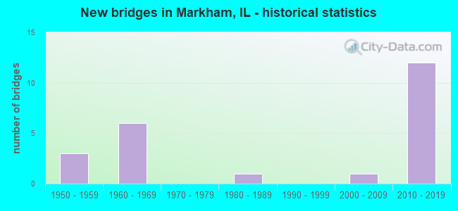
- New bridges - historical statistics
- 31950-1959
- 61960-1969
- 11980-1989
- 12000-2009
- 122010-2019

- Reconstructed bridges - Historical Statistics
- 11950-1959
- 01960-1969
- 11970-1979
- 01980-1989
- 01990-1999
- 12000-2009


- Bridge Condition - Deck
- 22.2%Very good
- 66.7%Good
- 11.1%Poor

- Bridge Condition - Superstructure
- 33.3%Very good
- 33.3%Good
- 22.2%Satisfactory
- 11.1%Serious

- Bridge Condition - Substructure
- 22.2%Very good
- 55.6%Good
- 11.1%Satisfactory
- 11.1%Fair

- Bridge Condition - Channel
- 20.0%Excellent
- 40.0%Very good
- 20.0%Fair
- 20.0%Serious

- Bridge Condition - Culverts
- 33.3%Good
- 66.7%Satisfactory
Find on map >> Show street view
Structure Number: 161013, Location: 1.6 M SW I-294 (Lat: 41.601728, Lng: -87.709469), Route carried "on" structure: US 6, Year Built: 1968, Status: Open, Structure Length: 7.52m (24.67ft), Average Daily Traffic: 24,200 (year 2021), Truck Traffic: 3%, Average Future Daily Traffic: 25,441 (year 2032), Design Load: HS 20+Mod, Features Intersected: I- 57
Minimum Vertical Clearance: 30+ m (98+ ft), Kilometerpoint: 272.165, Lanes on structure: 6, Lanes under structure: 8, Base Highway Network: Yes, Owner: State Highway Agency, Approaching Roadway Width: 25.5m (83.7ft), Skew: 31 degrees, Material/Design: Steel continuous, Design/Construction: Stringer/Multi-beam, Number Of Spans In Main Unit: 2, Length of Maximum Span: 37.2m (122.0ft), Curb-To-Curb Width: 25.5m (83.7ft), Out-to-Out Width: 27.4m (89.9ft)
Condition: Deck: Poor, Superstructure: Serious, Substructure: Fair, Operating Rating: 53.5 metric tons, Method Used To Determine Operating Rating: Load Factor (LF) rating reported by rating factor (RF) method using MS18 loading, Inventory Rating: 32.1 metric tons, Method Used To Determine Inventory Rating: Load Factor (LF) rating reported by rating factor (RF) method using MS18 loading, Structural Evaluation: High priority of corrective action, Deck Geometry: Somewhat better than minimum adequacy, Underclear: Somewhat better than minimum adequacy, Approach Roadway Alignment: Equal to present desirable criteria, Designated Inspection Frequency: Every 12 months, Inspection Date: October 2021, Deck Structure Type: Concrete Cast-file-Place, Wearing Surface/Protective System: Wearing Surface: Other
Find on map >> Show street view
Structure Number: 161015, Location: 2.1 M SW I-294 (Lat: 41.597089, Lng: -87.714889), Route carried "on" structure: Other road , Year Built: 1968, Year Reconstructed: 2012, Status: Open, Structure Length: 6.22m (20.41ft), Average Daily Traffic: 12,500 (year 2018), Truck Traffic: 8%, Average Future Daily Traffic: 13,699 (year 2032), Design Load: HS 20, Features Intersected: I- 57, Facility Carried by Structure: CRAWFORD AVE
Minimum Vertical Clearance: 30+ m (98+ ft), Kilometerpoint: 13.776, Lanes on structure: 4, Lanes under structure: 7, Base Highway Network: Yes, Owner: State Highway Agency, Approaching Roadway Width: 16.5m (54.1ft), Skew: 31 degrees, Material/Design: Steel continuous, Design/Construction: Stringer/Multi-beam, Number Of Spans In Main Unit: 2, Number Of Approach Spans: 1, Length of Maximum Span: 26.0m (85.3ft), Curb or Sidewalk Widths: Left: 2.0m (6.6ft), Right: 2.0m (6.6ft), Curb-To-Curb Width: 15.2m (49.9ft), Out-to-Out Width: 21.0m (68.9ft)
Condition: Deck: Good, Superstructure: Satisfactory, Substructure: Satisfactory, Operating Rating: 66.1 metric tons, Method Used To Determine Operating Rating: Load Factor (LF) rating reported by rating factor (RF) method using MS18 loading, Inventory Rating: 39.9 metric tons, Method Used To Determine Inventory Rating: Load Factor (LF) rating reported by rating factor (RF) method using MS18 loading, Structural Evaluation: Equal to present minimum criteria, Deck Geometry: High priority of corrective action, Underclear: High priority of corrective action, Approach Roadway Alignment: Equal to present desirable criteria, Length Of Structure Improvement: 5.21m (17.09ft), Designated Inspection Frequency: Every 24 months, Inspection Date: July 2020, Bridge Improvement Cost: $731,000, Roadway Improvement Cost: $73,000, Total Project Cost: $1,057,000, Deck Structure Type: Concrete Cast-file-Place, Wearing Surface/Protective System: Deck Protection: Epoxy Coated Reinforcing
Find on map >> Show street view
Structure Number: 161196, Location: 0.6 M S OF I-294 (Lat: 41.611719, Lng: -87.696481), Route carried "on" structure: Other road , Year Built: 2012, Status: Open, Structure Length: 8.72m (28.61ft), Average Daily Traffic: 12,500 (year 2018), Truck Traffic: 6%, Average Future Daily Traffic: 16,377 (year 2032), Design Load: HS 25 or greater, Features Intersected: I- 57, Facility Carried by Structure: KEDZIE AVE
Minimum Vertical Clearance: 30+ m (98+ ft), Kilometerpoint: 42.486, Lanes on structure: 4, Lanes under structure: 16, Base Highway Network: Yes, Owner: State Highway Agency, Approaching Roadway Width: 20.7m (67.9ft), Skew: 30 degrees, Material/Design: Steel continuous, Design/Construction: Stringer/Multi-beam, Number Of Spans In Main Unit: 2, Length of Maximum Span: 44.6m (146.3ft), Curb or Sidewalk Widths: Left: 1.5m (4.9ft), Right: 1.5m (4.9ft), Curb-To-Curb Width: 16.5m (54.1ft), Out-to-Out Width: 20.7m (67.9ft)
Condition: Deck: Good, Superstructure: Good, Substructure: Good, Operating Rating: 74.8 metric tons, Method Used To Determine Operating Rating: Load Factor (LF) rating reported by rating factor (RF) method using MS18 loading, Inventory Rating: 44.7 metric tons, Method Used To Determine Inventory Rating: Load Factor (LF) rating reported by rating factor (RF) method using MS18 loading, Structural Evaluation: Better than present minimum criteria, Deck Geometry: Meets minimum limits, Underclear: High priority of corrective action, Approach Roadway Alignment: Equal to present desirable criteria, Designated Inspection Frequency: Every 24 months, Inspection Date: August 2020, Deck Structure Type: Concrete Cast-file-Place, Wearing Surface/Protective System: Deck Protection: Epoxy Coated Reinforcing
Find on map >> Show street view
Structure Number: 161251, Location: 0.6 M S OF IL 83 (Lat: 41.618108, Lng: -87.687450), Route carried "on" structure: Interstate 57, Year Built: 2011, Status: Open, Structure Length: 8.18m (26.84ft), Average Daily Traffic: 97,400 (year 2021), Truck Traffic: 5%, Average Future Daily Traffic: 66,178 (year 2032), Design Load: HS 25 or greater, Features Intersected: I-294
Minimum Vertical Clearance: 30+ m (98+ ft), Kilometerpoint: 562.563, Lanes on structure: 6, Lanes under structure: 6, Base Highway Network: Yes, Owner: State Highway Agency, Approaching Roadway Width: 56.4m (185.0ft), Skew: 32 degrees, Material/Design: Steel continuous, Design/Construction: Stringer/Multi-beam, Number Of Spans In Main Unit: 3, Length of Maximum Span: 26.9m (88.3ft), Curb-To-Curb Width: 56.4m (185.0ft), Out-to-Out Width: 59.1m (193.9ft)
Condition: Deck: Good, Superstructure: Good, Substructure: Very good, Operating Rating: 53.1 metric tons, Method Used To Determine Operating Rating: Load and Resistance Factor Rating (LRFR) rating reported by rating factor(RF) method using HL-93 loadings, Inventory Rating: 41.1 metric tons, Method Used To Determine Inventory Rating: Load and Resistance Factor Rating (LRFR) rating reported by rating factor(RF) method using HL-93 loadings, Structural Evaluation: Better than present minimum criteria, Deck Geometry: Superior to present desirable criteria, Underclear: Meets minimum limits, Approach Roadway Alignment: Equal to present desirable criteria, Designated Inspection Frequency: Every 24 months, Inspection Date: April 2020, Deck Structure Type: Concrete Cast-file-Place, Wearing Surface/Protective System: Deck Protection: Epoxy Coated Reinforcing
Find on map >> Show street view
Structure Number: 161252, Location: .04M N of I294/I57 (Lat: 41.618842, Lng: -87.686489), Route carried "on" structure: Interstate 57, Year Built: 2011, Status: Open, Structure Length: 2.28m (7.48ft), Average Daily Traffic: 97,400 (year 2021), Truck Traffic: 5%, Average Future Daily Traffic: 109,077 (year 2032), Features Intersected: I- 57NB 2 I-294NB
Minimum Vertical Clearance: 30+ m (98+ ft), Kilometerpoint: 562.660, Lanes on structure: 6, Lanes under structure: 2, Base Highway Network: Yes, Owner: State Highway Agency, Approaching Roadway Width: 56.4m (185.0ft), Skew: 30 degrees, Material/Design: Steel, Design/Construction: Stringer/Multi-beam, Number Of Spans In Main Unit: 1, Length of Maximum Span: 20.9m (68.6ft), Curb-To-Curb Width: 56.4m (185.0ft), Out-to-Out Width: 59.2m (194.2ft)
Condition: Deck: Good, Superstructure: Very good, Substructure: Very good, Operating Rating: 73.2 metric tons, Method Used To Determine Operating Rating: Load and Resistance Factor Rating (LRFR) rating reported by rating factor(RF) method using HL-93 loadings, Inventory Rating: 56.7 metric tons, Method Used To Determine Inventory Rating: Load and Resistance Factor Rating (LRFR) rating reported by rating factor(RF) method using HL-93 loadings, Structural Evaluation: Equal to present desirable criteria, Deck Geometry: Superior to present desirable criteria, Approach Roadway Alignment: Equal to present desirable criteria, Designated Inspection Frequency: Every 24 months, Inspection Date: April 2020, Deck Structure Type: Concrete Cast-file-Place, Wearing Surface/Protective System: Deck Protection: Epoxy Coated Reinforcing
Find on map >> Show street view
Structure Number: 16136, Location: 0.3 M W Western Ave (Lat: 41.600847, Lng: -87.681256), Route carried "on" structure: US 6, Year Built: 2018, Status: Open, Structure Length: 7.79m (25.56ft), Average Daily Traffic: 25,600 (year 2021), Truck Traffic: 10%, Average Future Daily Traffic: 29,870 (year 2032), Design Load: HS 25 or greater, Features Intersected: I-294 TRI-STATE TOLL
Minimum Vertical Clearance: 30+ m (98+ ft), Kilometerpoint: 274.563, Lanes on structure: 6, Lanes under structure: 12, Base Highway Network: Yes, Owner: State Highway Agency, Approaching Roadway Width: 24.4m (80.1ft), Skew: 30 degrees, Material/Design: Prestressed concrete continuous, Design/Construction: Stringer/Multi-beam, Number Of Spans In Main Unit: 2, Length of Maximum Span: 38.1m (125.0ft), Curb or Sidewalk Widths: Left: 3.0m (9.8ft), Right: 2.1m (6.9ft), Curb-To-Curb Width: 24.4m (80.1ft), Out-to-Out Width: 30.5m (100.1ft)
Condition: Deck: Very good, Superstructure: Very good, Substructure: Good, Operating Rating: 75.2 metric tons, Method Used To Determine Operating Rating: Load and Resistance Factor Rating (LRFR) rating reported by rating factor(RF) method using HL-93 loadings, Inventory Rating: 32.4 metric tons, Method Used To Determine Inventory Rating: Load and Resistance Factor Rating (LRFR) rating reported by rating factor(RF) method using HL-93 loadings, Structural Evaluation: Better than present minimum criteria, Deck Geometry: Somewhat better than minimum adequacy, Underclear: Meets minimum limits, Approach Roadway Alignment: Equal to present desirable criteria, Designated Inspection Frequency: Every 24 months, Inspection Date: April 2020, Deck Structure Type: Concrete Cast-file-Place, Wearing Surface/Protective System: Deck Protection: Epoxy Coated Reinforcing
Find on map >> Show street view
Structure Number: 1621, Location: RAMP B (Lat: 41.614403, Lng: -87.691544), Route carried "on" structure: Other road , Year Built: 2014, Status: Open, Structure Length: 58.84m (193.04ft), Average Daily Traffic: 13,300 (year 2021), Average Future Daily Traffic: 11,220 (year 2038), Design Load: HS 25 or greater, Features Intersected: RAMP C & I-294, Facility Carried by Structure: I- 57NB RMP TO 294
Minimum Vertical Clearance: 30+ m (98+ ft), Kilometerpoint: 0.692, Lanes on structure: 2, Lanes under structure: 8, Base Highway Network: Yes (Inventory Route: 10057041, Subroute: 90), Owner: State Toll Authority, Approaching Roadway Width: 7.3m (24.0ft), Material/Design: Steel continuous, Design/Construction: Stringer/Multi-beam, Number Of Spans In Main Unit: 12, Length of Maximum Span: 71.3m (233.9ft), Curb-To-Curb Width: 13.3m (43.6ft), Out-to-Out Width: 14.2m (46.6ft)
Condition: Deck: Very good, Superstructure: Very good, Substructure: Good, Channel: Excellent, Operating Rating: 71.6 metric tons, Method Used To Determine Operating Rating: Load and Resistance Factor Rating (LRFR) rating reported by rating factor(RF) method using HL-93 loadings, Inventory Rating: 40.8 metric tons, Method Used To Determine Inventory Rating: Load and Resistance Factor Rating (LRFR) rating reported by rating factor(RF) method using HL-93 loadings, Structural Evaluation: Better than present minimum criteria, Deck Geometry: Superior to present desirable criteria, Waterway Adequacy: Superior to present desirable criteria, Approach Roadway Alignment: Equal to present desirable criteria, Designated Inspection Frequency: Every 24 months, Inspection Date: April 2021, Deck Structure Type: Concrete Cast-file-Place, Wearing Surface/Protective System: Deck Protection: Epoxy Coated Reinforcing
Find on map >> Show street view
Structure Number: 162215, Location: FROM I57 TO I294 (Lat: 41.600722, Lng: -87.701728), Route carried "on" structure: US 6, Year Built: 1962, Year Reconstructed: 1963, Status: Open, Structure Length: 139.45m (457.51ft), Average Daily Traffic: 20,500 (year 2021), Truck Traffic: 7%, Average Future Daily Traffic: 24,411 (year 2032), Features Intersected: ALONG US 6 EB LANES
Minimum Vertical Clearance: 30+ m (98+ ft), Kilometerpoint: 272.825, Lanes on structure: 4, Base Highway Network: Yes, Owner: State Highway Agency, Approaching Roadway Width: 14.6m (47.9ft), Material/Design: Concrete continuous, Design/Construction: Culvert, Number Of Spans In Main Unit: 2, Length of Maximum Span: 3.5m (11.5ft)
Condition: Channel: Fair, Culverts: Satisfactory, Operating Rating: 38.2 metric tons, Method Used To Determine Operating Rating: Load Factor (LF) rating reported by rating factor (RF) method using MS18 loading, Inventory Rating: 23.0 metric tons, Method Used To Determine Inventory Rating: Load Factor (LF) rating reported by rating factor (RF) method using MS18 loading, Structural Evaluation: Somewhat better than minimum adequacy, Waterway Adequacy: Equal to present minimum criteria, Approach Roadway Alignment: Equal to present desirable criteria, Designated Inspection Frequency: Every 24 months, Inspection Date: July 2020
Find on map >> Show street view
Structure Number: 162659, Location: 0.33 M S US 6 (Lat: 41.596464, Lng: -87.666622), Route carried "on" structure: Other road , Year Built: 2002, Status: Open, Structure Length: 2.28m (7.48ft), Average Daily Traffic: 10,600 (year 2021), Truck Traffic: 9%, Average Future Daily Traffic: 17,098 (year 2032), Features Intersected: CAL UNION DITCH, Facility Carried by Structure: DIXIE HWY
Minimum Vertical Clearance: 30+ m (98+ ft), Kilometerpoint: 0.499, Lanes on structure: 4, Base Highway Network: Yes, Owner: State Highway Agency, Approaching Roadway Width: 19.2m (63.0ft), Material/Design: Steel continuous, Design/Construction: Stringer/Multi-beam, Number Of Spans In Main Unit: 2, Length of Maximum Span: 11.1m (36.4ft), Curb-To-Curb Width: 19.2m (63.0ft), Out-to-Out Width: 20.2m (66.3ft)
Condition: Deck: Good, Superstructure: Satisfactory, Substructure: Good, Channel: Very good, Operating Rating: 69.7 metric tons, Method Used To Determine Operating Rating: Load Factor (LF) rating reported by rating factor (RF) method using MS18 loading, Inventory Rating: 41.8 metric tons, Method Used To Determine Inventory Rating: Load Factor (LF) rating reported by rating factor (RF) method using MS18 loading, Structural Evaluation: Equal to present minimum criteria, Deck Geometry: Equal to present minimum criteria, Waterway Adequacy: Equal to present desirable criteria, Approach Roadway Alignment: Equal to present desirable criteria, Designated Inspection Frequency: Every 24 months, Inspection Date: July 2020, Deck Structure Type: Concrete Cast-file-Place, Wearing Surface/Protective System: Deck Protection: Epoxy Coated Reinforcing
Find on map >> Show street view
Structure Number: 162751, Location: 02 MI N. US 6 (Lat: 41.601600, Lng: -87.681269), Route carried "on" structure: Interstate 294, Year Built: 1958, Status: Open, Structure Length: 1.30m (4.27ft), Average Daily Traffic: 91,600 (year 2020), Truck Traffic: 22%, Average Future Daily Traffic: 91,670 (year 2032), Design Load: HS 20, Features Intersected: 159TH CREEK
Minimum Vertical Clearance: 30+ m (98+ ft), Kilometerpoint: 74.559, Lanes on structure: 6, Base Highway Network: Yes, Toll: On toll road, Owner: State Toll Authority, Approaching Roadway Width: 36.6m (120.1ft), Skew: 2 degrees, Material/Design: Concrete, Design/Construction: Culvert, Number Of Spans In Main Unit: 3, Length of Maximum Span: 3.9m (12.8ft)
Condition: Channel: Very good, Culverts: Good, Operating Rating: 97.2 metric tons, Method Used To Determine Operating Rating: Load Factor (LF) rating reported by rating factor (RF) method using MS18 loading, Inventory Rating: 71.3 metric tons, Method Used To Determine Inventory Rating: Load Factor (LF) rating reported by rating factor (RF) method using MS18 loading, Structural Evaluation: Better than present minimum criteria, Waterway Adequacy: Superior to present desirable criteria, Approach Roadway Alignment: Equal to present desirable criteria, Designated Inspection Frequency: Every 24 months, Inspection Date: May 2019, Deck Structure Type: Concrete Cast-file-Place
Find on map >> Show street view
Structure Number: 16328, Location: 300 FT. E. OF I-294 (Lat: 41.586244, Lng: -87.679881), Route carried "on" structure: Other road , Year Built: 1983, Status: Open, Structure Length: 0.94m (3.08ft), Average Daily Traffic: 16,000 (year 2018), Truck Traffic: 11%, Average Future Daily Traffic: 23,200 (year 2042), Design Load: HS 20, Features Intersected: CALUMET-UNION DRAIN, Facility Carried by Structure: 167TH STREET
Minimum Vertical Clearance: 30+ m (98+ ft), Kilometerpoint: 9.624, Lanes on structure: 4, Base Highway Network: Yes, Owner: County Highway Agency, Approaching Roadway Width: 20.7m (67.9ft), Skew: 34 degrees, Material/Design: Concrete, Design/Construction: Culvert, Number Of Spans In Main Unit: 2, Length of Maximum Span: 3.3m (10.8ft)
Condition: Channel: Serious, Culverts: Satisfactory, Operating Rating: 40.5 metric tons, Method Used To Determine Operating Rating: Field evaluation and documented engineering judgment, Inventory Rating: 24.3 metric tons, Method Used To Determine Inventory Rating: Field evaluation and documented engineering judgment, Structural Evaluation: Equal to present minimum criteria, Waterway Adequacy: Superior to present desirable criteria, Approach Roadway Alignment: Equal to present desirable criteria, Designated Inspection Frequency: Every 24 months, Inspection Date: August 2021
Find on map >> Show street view
Structure Number: 169711, Location: 0.2 M N I80 (Lat: 41.586231, Lng: -87.681217), Route carried "on" structure: Other road , Year Built: 1957, Year Reconstructed: 1982, Status: Open, Structure Length: 6.64m (21.78ft), Average Daily Traffic: 16,000 (year 2018), Truck Traffic: 11%, Average Future Daily Traffic: 17,716 (year 2032), Design Load: HS 20, Features Intersected: I 294, Facility Carried by Structure: 167TH ST
Minimum Vertical Clearance: 30+ m (98+ ft), Kilometerpoint: 9.495, Lanes on structure: 4, Lanes under structure: 4, Base Highway Network: Yes, Owner: County Highway Agency, Approaching Roadway Width: 12.8m (42.0ft), Skew: 20 degrees, Material/Design: Prestressed concrete, Design/Construction: Stringer/Multi-beam, Number Of Spans In Main Unit: 4, Length of Maximum Span: 20.0m (65.6ft), Curb or Sidewalk Widths: Left: 1.5m (4.9ft), Right: 1.5m (4.9ft), Curb-To-Curb Width: 20.1m (65.9ft), Out-to-Out Width: 23.8m (78.1ft)
Condition: Deck: Good, Superstructure: Good, Substructure: Good, Operating Rating: 69.7 metric tons, Method Used To Determine Operating Rating: Load Factor (LF) rating reported by rating factor (RF) method using MS18 loading, Inventory Rating: 41.8 metric tons, Method Used To Determine Inventory Rating: Load Factor (LF) rating reported by rating factor (RF) method using MS18 loading, Structural Evaluation: Better than present minimum criteria, Deck Geometry: Better than present minimum criteria, Underclear: Meets minimum limits, Approach Roadway Alignment: Better than present minimum criteria, Designated Inspection Frequency: Every 24 months, Inspection Date: April 2020, Deck Structure Type: Concrete Cast-file-Place
Find on map >> Show street view
Structure Number: 161013, Location: 1.6 M SW I-294 (Lat: 41.601572, Lng: -87.709044), Route carried "under" structure: Interstate 57, Year Built: 1968, Structure Length: 0. m, Average Daily Traffic: 101,700 (year 2021), Truck Traffic: 6%, Features Intersected: I- 57, Facility Carried by Structure: US 6 (159TH ST)
Minimum Vertical Clearance: 4.93m (16.17ft), Kilometerpoint: 559.988, Lanes on structure: 6, Lanes under structure: 8, Material/Design: Steel continuous, Design/Construction: Stringer/Multi-beam, Length of Maximum Span: 37.2m (122.0ft)
Find on map >> Show street view
Structure Number: 161015, Location: 2.1 M SW I-294 (Lat: 41.597089, Lng: -87.714889), Route carried "under" structure: Interstate 57, Year Built: 1968, Structure Length: 0. m, Average Daily Traffic: 116,200 (year 2021), Truck Traffic: 3%, Features Intersected: I- 57, Facility Carried by Structure: CRAWFORD AVE
Minimum Vertical Clearance: 4.85m (15.91ft), Kilometerpoint: 559.312, Lanes on structure: 4, Lanes under structure: 7, Material/Design: Steel continuous, Design/Construction: Stringer/Multi-beam, Length of Maximum Span: 26.0m (85.3ft)
Find on map >> Show street view
Structure Number: 161196, Location: 0.6 M S OF I-294 (Lat: 41.611267, Lng: -87.696006), Route carried "under" structure: Other road , Year Built: 2012, Structure Length: 0. m, Average Daily Traffic: 13,300 (year 2021), Features Intersected: I- 57, Facility Carried by Structure: KEDZIE AVE
Minimum Vertical Clearance: 5.16m (16.93ft), Kilometerpoint: 0.097, Lanes on structure: 4, Lanes under structure: 8, Material/Design: Steel continuous, Design/Construction: Stringer/Multi-beam, Length of Maximum Span: 44.6m (146.3ft)
Find on map >> Show street view
Structure Number: 161196, Location: 0.6 M S OF I-294 (Lat: 41.611947, Lng: -87.695958), Route carried "under" structure: Other road , Year Built: 2012, Structure Length: 0. m, Average Daily Traffic: 12,900 (year 2021), Features Intersected: I- 57, Facility Carried by Structure: KEDZIE AVE
Minimum Vertical Clearance: 5.16m (16.93ft), Kilometerpoint: 1.690, Lanes on structure: 4, Lanes under structure: 2, Material/Design: Steel continuous, Design/Construction: Stringer/Multi-beam, Length of Maximum Span: 44.6m (146.3ft)
Find on map >> Show street view
Structure Number: 161196, Location: 0.6 M S OF I-294 (Lat: 41.611381, Lng: -87.696139), Route carried "under" structure: Interstate 57, Year Built: 2012, Structure Length: 0. m, Average Daily Traffic: 123,600 (year 2021), Truck Traffic: 5%, Features Intersected: I- 57, Facility Carried by Structure: KEDZIE AVE
Minimum Vertical Clearance: 5.16m (16.93ft), Kilometerpoint: 561.517, Lanes on structure: 4, Lanes under structure: 6, Material/Design: Steel continuous, Design/Construction: Stringer/Multi-beam, Length of Maximum Span: 44.6m (146.3ft)
Find on map >> Show street view
Structure Number: 161251, Location: 0.6 M S OF IL 83 (Lat: 41.618444, Lng: -87.687378), Route carried "under" structure: Interstate 294, Year Built: 2011, Structure Length: 0. m, Average Daily Traffic: 91,600 (year 2020), Truck Traffic: 22%, Features Intersected: I-294, Facility Carried by Structure: I- 57
Minimum Vertical Clearance: 4.85m (15.91ft), Kilometerpoint: 72.596, Lanes on structure: 6, Lanes under structure: 6, Material/Design: Steel continuous, Design/Construction: Stringer/Multi-beam, Length of Maximum Span: 26.9m (88.3ft)
Find on map >> Show street view
Structure Number: 161252, Location: .04M N of I294/I57 (Lat: 41.618739, Lng: -87.686394), Route carried "under" structure: Other road , Year Built: 2011, Structure Length: 0. m, Average Daily Traffic: 13,300 (year 2021), Features Intersected: I- 57NB 2 I-294NB, Facility Carried by Structure: I- 57
Minimum Vertical Clearance: 5.38m (17.65ft), Kilometerpoint: 1.577, Lanes on structure: 6, Lanes under structure: 2, Material/Design: Steel, Design/Construction: Stringer/Multi-beam, Length of Maximum Span: 20.9m (68.6ft)
Find on map >> Show street view
Structure Number: 16136, Location: 0.3 M W Western Ave (Lat: 41.600847, Lng: -87.681256), Route carried "under" structure: Interstate 294, Year Built: 2018, Structure Length: 0. m, Average Daily Traffic: 92,400 (year 2020), Truck Traffic: 14%, Features Intersected: I-294 TRI-STATE TOLL, Facility Carried by Structure: US 6 (159TH ST)
Minimum Vertical Clearance: 5.13m (16.83ft), Kilometerpoint: 74.639, Lanes on structure: 6, Lanes under structure: 12, Material/Design: Prestressed concrete continuous, Design/Construction: Stringer/Multi-beam, Length of Maximum Span: 38.1m (125.0ft)
Find on map >> Show street view
Structure Number: 162035, Location: 1.3 M SW I294 P3 (Lat: 41.604317, Lng: -87.705489), Route carried "under" structure: Interstate 57, Year Built: 1968, Structure Length: 0. m, Average Daily Traffic: 101,700 (year 2021), Truck Traffic: 6%, Features Intersected: I-57
Minimum Vertical Clearance: 5.97m (19.59ft), Kilometerpoint: 560.487, Lanes under structure: 6, Material/Design: Steel continuous, Length of Maximum Span: 32.6m (107.0ft)
Find on map >> Show street view
Structure Number: 1621, Location: RAMP B (Lat: 41.616244, Lng: -87.686144), Route carried "under" structure: Interstate 294, Year Built: 2014, Structure Length: 0. m, Average Daily Traffic: 91,600 (year 2020), Truck Traffic: 22%, Features Intersected: RAMP C & I-294
Minimum Vertical Clearance: 5.26m (17.26ft), Kilometerpoint: 72.885, Lanes on structure: 2, Lanes under structure: 8, Material/Design: Steel continuous, Design/Construction: Stringer/Multi-beam, Length of Maximum Span: 71.3m (233.9ft)
Find on map >> Show street view
Structure Number: 169711, Location: 0.2 M N I80 (Lat: 41.586378, Lng: -87.681158), Route carried "under" structure: Interstate 294, Year Built: 1957, Structure Length: 0. m, Average Daily Traffic: 92,400 (year 2020), Truck Traffic: 14%, Features Intersected: I 294, Facility Carried by Structure: 167TH ST
Minimum Vertical Clearance: 4.65m (15.26ft), Kilometerpoint: 76.249, Lanes on structure: 4, Lanes under structure: 4, Material/Design: Prestressed concrete, Design/Construction: Stringer/Multi-beam, Length of Maximum Span: 20.0m (65.6ft)