Bridge Statistics for San Dimas, California (CA)
Condition, Traffic, Stress, Structural Evaluation, Project Costs
- National Bridge Inventory (NBI) Statistics
- 42Number of bridges
- 472ft / 144mTotal length
- 3,060,001Total average daily traffic
- 136,067Total average daily truck traffic
- National Bridge Inventory (NBI) Registered Bridges for San Dimas
- No street view available for this location
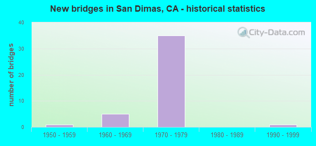
- New bridges - historical statistics
- 11950-1959
- 51960-1969
- 351970-1979
- 11990-1999


- Bridge Condition - Deck
- 71.4%Good
- 4.8%Satisfactory
- 19.0%Fair
- 4.8%Poor

- Bridge Condition - Superstructure
- 47.6%Good
- 4.8%Satisfactory
- 47.6%Fair

- Bridge Condition - Substructure
- 95.2%Good
- 4.8%Fair

- Bridge Condition - Channel
- 25.0%Excellent
- 50.0%Very good
- 12.5%Good
- 12.5%Satisfactory

- Bridge Condition - Culverts
- 20.0%Good
- 80.0%Satisfactory
Find on map >> Show street view
Structure Number: 53 1931, Location: 07-LA-057-R11.15-SDMS (Lat: 34.110981, Lng: -117.823461), Route carried "on" structure: State highway 57, Year Built: 1971, Status: Open, Structure Length: 7.19m (23.59ft), Average Daily Traffic: 158,000 (year 2012), Truck Traffic: 5%, Average Future Daily Traffic: 146,359 (year 2040), Design Load: HS 20, Features Intersected: LACMTA & BNSF RY
Minimum Vertical Clearance: 30+ m (98+ ft), Kilometerpoint: 11.150, Lanes on structure: 10, Base Highway Network: Yes (, Subroute: 1), Owner: State Highway Agency, Approaching Roadway Width: 50.6m (166.0ft), Skew: 35 degrees, Material/Design: Concrete continuous, Design/Construction: Box Beam or Girders - Multiple, Number Of Spans In Main Unit: 3, Length of Maximum Span: 28.7m (94.2ft), Curb-To-Curb Width: 50.6m (166.0ft), Out-to-Out Width: 51.8m (169.9ft)
Condition: Deck: Good, Superstructure: Good, Substructure: Good, Operating Rating: 44.4 metric tons, Method Used To Determine Operating Rating: Load and Resistance Factor Rating (LRFR) rating reported by rating factor(RF) method using HL-93 loadings, Inventory Rating: 34.3 metric tons, Method Used To Determine Inventory Rating: Load and Resistance Factor Rating (LRFR) rating reported by rating factor(RF) method using HL-93 loadings, Structural Evaluation: Better than present minimum criteria, Deck Geometry: Superior to present desirable criteria, Underclear: Superior to present desirable criteria, Approach Roadway Alignment: Better than present minimum criteria, Designated Inspection Frequency: Every 24 months, Inspection Date: September 2020, Deck Structure Type: Concrete Cast-file-Place
Find on map >> Show street view
Structure Number: 53 1949, Location: 07-LA-057-R10.40-SDMS (Lat: 34.101083, Lng: -117.819167), Route carried "on" structure: State highway 57, Year Built: 1971, Status: Open, Structure Length: 3.72m (12.20ft), Average Daily Traffic: 158,000 (year 2012), Truck Traffic: 5%, Average Future Daily Traffic: 146,359 (year 2040), Design Load: HS 20, Features Intersected: METROLINK & UP RR
Minimum Vertical Clearance: 30+ m (98+ ft), Kilometerpoint: 10.400, Lanes on structure: 9, Base Highway Network: Yes (, Subroute: 1), Owner: State Highway Agency, Approaching Roadway Width: 46.9m (153.9ft), Skew: 30 degrees, Material/Design: Concrete continuous, Design/Construction: Tee Beam, Number Of Spans In Main Unit: 3, Length of Maximum Span: 12.8m (42.0ft), Curb-To-Curb Width: 46.9m (153.9ft), Out-to-Out Width: 48.2m (158.1ft)
Condition: Deck: Good, Superstructure: Good, Substructure: Good, Operating Rating: 38.6 metric tons, Method Used To Determine Operating Rating: Load and Resistance Factor Rating (LRFR) rating reported by rating factor(RF) method using HL-93 loadings, Inventory Rating: 29.8 metric tons, Method Used To Determine Inventory Rating: Load and Resistance Factor Rating (LRFR) rating reported by rating factor(RF) method using HL-93 loadings, Structural Evaluation: Better than present minimum criteria, Deck Geometry: Superior to present desirable criteria, Underclear: Equal to present minimum criteria, Approach Roadway Alignment: Equal to present desirable criteria, Designated Inspection Frequency: Every 24 months, Inspection Date: September 2020, Deck Structure Type: Concrete Cast-file-Place
Find on map >> Show street view
Structure Number: 53 1954, Location: 07-LA-057-R10.74-SDMS (Lat: 34.106467, Lng: -117.821242), Route carried "on" structure: State highway 57, Year Built: 1971, Status: Open, Structure Length: 5.18m (16.99ft), Average Daily Traffic: 158,000 (year 2012), Truck Traffic: 5%, Average Future Daily Traffic: 146,359 (year 2040), Design Load: HS 20, Features Intersected: ARROW HWY
Minimum Vertical Clearance: 30+ m (98+ ft), Kilometerpoint: 10.740, Lanes on structure: 10, Lanes under structure: 4, Base Highway Network: Yes (, Subroute: 1), Owner: State Highway Agency, Approaching Roadway Width: 50.6m (166.0ft), Skew: 32 degrees, Material/Design: Prestressed concrete continuous, Design/Construction: Box Beam or Girders - Multiple, Number Of Spans In Main Unit: 2, Length of Maximum Span: 25.6m (84.0ft), Curb-To-Curb Width: 50.0m (164.0ft), Out-to-Out Width: 51.2m (168.0ft)
Condition: Deck: Good, Superstructure: Good, Substructure: Good, Operating Rating: 27.5 metric tons, Method Used To Determine Operating Rating: Load and Resistance Factor Rating (LRFR) rating reported by rating factor(RF) method using HL-93 loadings, Inventory Rating: 18.1 metric tons, Method Used To Determine Inventory Rating: Load and Resistance Factor Rating (LRFR) rating reported by rating factor(RF) method using HL-93 loadings, Structural Evaluation: Meets minimum limits, Deck Geometry: Superior to present desirable criteria, Underclear: Meets minimum limits, Approach Roadway Alignment: Equal to present desirable criteria, Designated Inspection Frequency: Every 24 months, Inspection Date: September 2020, Deck Structure Type: Concrete Cast-file-Place
Find on map >> Show street view
Structure Number: 53 1961G, Location: 07-LA-005S-C45.63-LA (Lat: 34.334800, Lng: -118.505389), Route carried "on" structure: Interstate 5, Year Built: 1971, Status: Open, Structure Length: 4.75m (15.58ft), Average Daily Traffic: 17,084 (year 2011), Truck Traffic: 8%, Average Future Daily Traffic: 23,598 (year 2038), Design Load: HS 20, Features Intersected: SIERRA HWY-N5 ON-RAMP
Minimum Vertical Clearance: 30+ m (98+ ft), Kilometerpoint: 45.630, Lanes on structure: 2, Lanes under structure: 1, Base Highway Network: Yes (, Subroute: 1), Owner: State Highway Agency, Approaching Roadway Width: 11.8m (38.7ft), Skew: 4 degrees, Material/Design: Concrete continuous, Design/Construction: Box Beam or Girders - Multiple, Number Of Spans In Main Unit: 3, Length of Maximum Span: 18.9m (62.0ft), Curb-To-Curb Width: 11.8m (38.7ft), Out-to-Out Width: 12.5m (41.0ft)
Condition: Deck: Good, Superstructure: Good, Substructure: Good, Operating Rating: 40.5 metric tons, Method Used To Determine Operating Rating: Load and Resistance Factor Rating (LRFR) rating reported by rating factor(RF) method using HL-93 loadings, Inventory Rating: 31.4 metric tons, Method Used To Determine Inventory Rating: Load and Resistance Factor Rating (LRFR) rating reported by rating factor(RF) method using HL-93 loadings, Structural Evaluation: Better than present minimum criteria, Deck Geometry: Equal to present minimum criteria, Underclear: Equal to present minimum criteria, Approach Roadway Alignment: Equal to present desirable criteria, Designated Inspection Frequency: Every 24 months, Inspection Date: April 2021, Deck Structure Type: Concrete Cast-file-Place
Find on map >> Show street view
Structure Number: 53 1969, Location: 07-LA-057-R10.53-SDMS (Lat: 34.102839, Lng: -117.819561), Route carried "on" structure: State highway 57, Year Built: 1971, Status: Open, Structure Length: 4.79m (15.72ft), Average Daily Traffic: 158,000 (year 2012), Truck Traffic: 5%, Average Future Daily Traffic: 146,359 (year 2040), Design Load: HS 20, Features Intersected: CIENEGA AVENUE
Minimum Vertical Clearance: 30+ m (98+ ft), Kilometerpoint: 10.530, Lanes on structure: 9, Lanes under structure: 4, Base Highway Network: Yes (, Subroute: 1), Owner: State Highway Agency, Approaching Roadway Width: 48.8m (160.1ft), Skew: 31 degrees, Material/Design: Prestressed concrete, Design/Construction: Box Beam or Girders - Multiple, Number Of Spans In Main Unit: 1, Length of Maximum Span: 47.2m (154.9ft), Curb-To-Curb Width: 46.3m (151.9ft), Out-to-Out Width: 47.5m (155.8ft)
Condition: Deck: Good, Superstructure: Good, Substructure: Good, Operating Rating: 68.7 metric tons, Method Used To Determine Operating Rating: Load and Resistance Factor Rating (LRFR) rating reported by rating factor(RF) method using HL-93 loadings, Inventory Rating: 43.4 metric tons, Method Used To Determine Inventory Rating: Load and Resistance Factor Rating (LRFR) rating reported by rating factor(RF) method using HL-93 loadings, Structural Evaluation: Better than present minimum criteria, Deck Geometry: Superior to present desirable criteria, Underclear: Somewhat better than minimum adequacy, Approach Roadway Alignment: Superior to present desirable criteria, Designated Inspection Frequency: Every 24 months, Inspection Date: September 2020, Deck Structure Type: Concrete Cast-file-Place
Find on map >> Show street view
Structure Number: 53 197, Location: 07-LA-210-R44.56-GDR (Lat: 34.120286, Lng: -117.823425), Route carried "on" structure: Interstate 210, Year Built: 1970, Status: Open, Structure Length: 4.72m (15.49ft), Average Daily Traffic: 191,000 (year 2012), Average Future Daily Traffic: 221,014 (year 2039), Design Load: HS 20, Features Intersected: W210-S57 CONNECTOR RAMP
Minimum Vertical Clearance: 30+ m (98+ ft), Kilometerpoint: 44.560, Lanes on structure: 10, Lanes under structure: 2, Base Highway Network: Yes (Inventory Route: 2, Subroute: 1), Owner: State Highway Agency, Approaching Roadway Width: 44.4m (145.7ft), Skew: 34 degrees, Material/Design: Prestressed concrete, Design/Construction: Box Beam or Girders - Multiple, Number Of Spans In Main Unit: 1, Length of Maximum Span: 45.4m (149.0ft), Curb-To-Curb Width: 44.4m (145.7ft), Out-to-Out Width: 45.1m (148.0ft)
Condition: Deck: Good, Superstructure: Fair, Substructure: Fair, Operating Rating: 90.4 metric tons, Method Used To Determine Operating Rating: Load Factor (LF), Inventory Rating: 32.4 metric tons, Method Used To Determine Inventory Rating: Load Factor (LF), Structural Evaluation: Somewhat better than minimum adequacy, Deck Geometry: Superior to present desirable criteria, Underclear: Superior to present desirable criteria, Approach Roadway Alignment: Equal to present desirable criteria, Designated Inspection Frequency: Every 24 months, Inspection Date: Febuary 2021, Deck Structure Type: Concrete Cast-file-Place
Find on map >> Show street view
Structure Number: 53 1976L, Location: 07-LA-057-R11.35L-SDMS (Lat: 34.113750, Lng: -117.824181), Route carried "on" structure: State highway 57, Year Built: 1971, Status: Open, Structure Length: 3.87m (12.70ft), Average Daily Traffic: 79,000 (year 2012), Truck Traffic: 5%, Average Future Daily Traffic: 73,179 (year 2040), Design Load: HS 20, Features Intersected: GLADSTONE STREET
Minimum Vertical Clearance: 30+ m (98+ ft), Kilometerpoint: 11.350, Lanes on structure: 6, Lanes under structure: 2, Base Highway Network: Yes (, Subroute: 1), Owner: State Highway Agency, Approaching Roadway Width: 27.4m (89.9ft), Material/Design: Prestressed concrete, Design/Construction: Tee Beam, Number Of Spans In Main Unit: 1, Length of Maximum Span: 38.1m (125.0ft), Curb-To-Curb Width: 27.4m (89.9ft), Out-to-Out Width: 28.0m (91.9ft)
Condition: Deck: Good, Superstructure: Fair, Substructure: Good, Operating Rating: 59.6 metric tons, Method Used To Determine Operating Rating: Load and Resistance Factor Rating (LRFR) rating reported by rating factor(RF) method using HL-93 loadings, Inventory Rating: 46.0 metric tons, Method Used To Determine Inventory Rating: Load and Resistance Factor Rating (LRFR) rating reported by rating factor(RF) method using HL-93 loadings, Structural Evaluation: Somewhat better than minimum adequacy, Deck Geometry: Equal to present minimum criteria, Underclear: Equal to present minimum criteria, Approach Roadway Alignment: Equal to present desirable criteria, Designated Inspection Frequency: Every 24 months, Inspection Date: September 2020, Deck Structure Type: Concrete Cast-file-Place
Find on map >> Show street view
Structure Number: 53 1976R, Location: 07-LA-057-R11.35R-SDMS (Lat: 34.113761, Lng: -117.823781), Route carried "on" structure: State highway 57, Year Built: 1971, Status: Open, Structure Length: 3.87m (12.70ft), Average Daily Traffic: 79,000 (year 2012), Truck Traffic: 5%, Average Future Daily Traffic: 73,179 (year 2040), Design Load: HS 20, Features Intersected: GLADSTONE STREET
Minimum Vertical Clearance: 30+ m (98+ ft), Kilometerpoint: 11.350, Lanes on structure: 5, Lanes under structure: 2, Base Highway Network: Yes (, Subroute: 1), Owner: State Highway Agency, Approaching Roadway Width: 23.2m (76.1ft), Material/Design: Prestressed concrete, Design/Construction: Tee Beam, Number Of Spans In Main Unit: 1, Length of Maximum Span: 38.7m (127.0ft), Curb-To-Curb Width: 23.2m (76.1ft), Out-to-Out Width: 23.8m (78.1ft)
Condition: Deck: Good, Superstructure: Fair, Substructure: Good, Operating Rating: 79.7 metric tons, Method Used To Determine Operating Rating: Load Factor (LF), Inventory Rating: 32.4 metric tons, Method Used To Determine Inventory Rating: Load Factor (LF), Structural Evaluation: Somewhat better than minimum adequacy, Deck Geometry: Somewhat better than minimum adequacy, Underclear: Equal to present minimum criteria, Approach Roadway Alignment: Equal to present desirable criteria, Designated Inspection Frequency: Every 24 months, Inspection Date: September 2020, Deck Structure Type: Concrete Cast-file-Place
Find on map >> Show street view
Structure Number: 53 1978F, Location: 07-LA-057-R7.94-SDMS (Lat: 34.068022, Lng: -117.806794), Route carried "on" structure: Ramp State highway 57, Year Built: 1972, Status: Open, Structure Length: 26.09m (85.60ft), Average Daily Traffic: 14,300 (year 2012), Truck Traffic: 5%, Average Future Daily Traffic: 18,921 (year 2040), Design Load: HS 20+Mod, Features Intersected: STATE ROUTE 57 & CONNS
Minimum Vertical Clearance: 5.20m (17.06ft), Kilometerpoint: 7.940, Lanes on structure: 2, Lanes under structure: 9, Base Highway Network: Yes, Owner: State Highway Agency, Approaching Roadway Width: 11.9m (39.0ft), Material/Design: Concrete continuous, Design/Construction: Box Beam or Girders - Multiple, Number Of Spans In Main Unit: 8, Length of Maximum Span: 44.8m (147.0ft), Curb-To-Curb Width: 11.9m (39.0ft), Out-to-Out Width: 12.5m (41.0ft)
Condition: Deck: Good, Superstructure: Fair, Substructure: Good, Operating Rating: 97.5 metric tons, Method Used To Determine Operating Rating: Load Factor (LF), Inventory Rating: 58.6 metric tons, Method Used To Determine Inventory Rating: Load Factor (LF), Structural Evaluation: Somewhat better than minimum adequacy, Deck Geometry: Superior to present desirable criteria, Underclear: Meets minimum limits, Approach Roadway Alignment: Equal to present desirable criteria, Designated Inspection Frequency: Every 24 months, Inspection Date: September 2020, Deck Structure Type: Concrete Cast-file-Place
Find on map >> Show street view
Structure Number: 53 1997, Location: 07-LA-057-R10.27-SDMS (Lat: 34.099203, Lng: -117.819078), Route carried "on" structure: State highway 57, Year Built: 1971, Status: Open, Structure Length: 5.52m (18.11ft), Average Daily Traffic: 158,000 (year 2012), Truck Traffic: 5%, Average Future Daily Traffic: 146,359 (year 2040), Design Load: HS 20, Features Intersected: COVINA BLVD
Minimum Vertical Clearance: 30+ m (98+ ft), Kilometerpoint: 10.270, Lanes on structure: 10, Lanes under structure: 4, Base Highway Network: Yes (, Subroute: 1), Owner: State Highway Agency, Approaching Roadway Width: 54.9m (180.1ft), Skew: 30 degrees, Material/Design: Prestressed concrete, Design/Construction: Box Beam or Girders - Multiple, Number Of Spans In Main Unit: 1, Length of Maximum Span: 54.6m (179.1ft), Curb-To-Curb Width: 54.3m (178.1ft), Out-to-Out Width: 55.5m (182.1ft)
Condition: Deck: Good, Superstructure: Fair, Substructure: Good, Operating Rating: 67.7 metric tons, Method Used To Determine Operating Rating: Load and Resistance Factor Rating (LRFR) rating reported by rating factor(RF) method using HL-93 loadings, Inventory Rating: 40.5 metric tons, Method Used To Determine Inventory Rating: Load and Resistance Factor Rating (LRFR) rating reported by rating factor(RF) method using HL-93 loadings, Structural Evaluation: Somewhat better than minimum adequacy, Deck Geometry: Superior to present desirable criteria, Underclear: Meets minimum limits, Approach Roadway Alignment: Equal to present desirable criteria, Designated Inspection Frequency: Every 24 months, Inspection Date: September 2020, Deck Structure Type: Concrete Cast-file-Place
Find on map >> Show street view
Structure Number: 53 2000G, Location: 07-LA-010-42.53-POM (Lat: 34.065164, Lng: -117.804800), Route carried "on" structure: Ramp Interstate 10, Year Built: 1972, Status: Open, Structure Length: 4.05m (13.29ft), Average Daily Traffic: 15,000 (year 2011), Truck Traffic: 2%, Average Future Daily Traffic: 16,486 (year 2038), Design Load: HS 20, Features Intersected: N57-E10 CONNECTOR RAMP
Minimum Vertical Clearance: 30+ m (98+ ft), Kilometerpoint: 42.530, Lanes on structure: 2, Lanes under structure: 2, Owner: State Highway Agency, Approaching Roadway Width: 9.8m (32.2ft), Skew: 4 degrees, Material/Design: Prestressed concrete, Design/Construction: Box Beam or Girders - Multiple, Number Of Spans In Main Unit: 1, Length of Maximum Span: 39.6m (129.9ft), Curb-To-Curb Width: 9.8m (32.2ft), Out-to-Out Width: 10.4m (34.1ft)
Condition: Deck: Good, Superstructure: Fair, Substructure: Good, Operating Rating: 67.1 metric tons, Method Used To Determine Operating Rating: Load and Resistance Factor Rating (LRFR) rating reported by rating factor(RF) method using HL-93 loadings, Inventory Rating: 45.0 metric tons, Method Used To Determine Inventory Rating: Load and Resistance Factor Rating (LRFR) rating reported by rating factor(RF) method using HL-93 loadings, Structural Evaluation: Somewhat better than minimum adequacy, Deck Geometry: Equal to present minimum criteria, Underclear: Superior to present desirable criteria, Approach Roadway Alignment: Equal to present desirable criteria, Designated Inspection Frequency: Every 24 months, Inspection Date: October 2021, Deck Structure Type: Concrete Cast-file-Place
Find on map >> Show street view
Structure Number: 53 2002, Location: 07-LA-057-R8.71-SDMS (Lat: 34.077783, Lng: -117.814414), Route carried "on" structure: City street L384, Year Built: 1971, Status: Open, Structure Length: 9.69m (31.79ft), Average Daily Traffic: 4,200 (year 2012), Truck Traffic: 2%, Average Future Daily Traffic: 6,181 (year 2040), Design Load: HS 20, Features Intersected: STATE ROUTE 57, Facility Carried by Structure: VIA VERDE
Minimum Vertical Clearance: 30+ m (98+ ft), Kilometerpoint: 0.000, Lanes on structure: 4, Lanes under structure: 12, Owner: State Highway Agency, Approaching Roadway Width: 20.1m (65.9ft), Skew: 9 degrees, Material/Design: Prestressed concrete continuous, Design/Construction: Box Beam or Girders - Multiple, Number Of Spans In Main Unit: 2, Length of Maximum Span: 52.4m (171.9ft), Curb or Sidewalk Widths: Left: 0.0m, Right: 1.5m (4.9ft), Curb-To-Curb Width: 20.1m (65.9ft), Out-to-Out Width: 22.3m (73.2ft)
Condition: Deck: Good, Superstructure: Fair, Substructure: Good, Operating Rating: 28.2 metric tons, Method Used To Determine Operating Rating: Load and Resistance Factor Rating (LRFR) rating reported by rating factor(RF) method using HL-93 loadings, Inventory Rating: 16.2 metric tons, Method Used To Determine Inventory Rating: Load and Resistance Factor Rating (LRFR) rating reported by rating factor(RF) method using HL-93 loadings, Structural Evaluation: Meets minimum limits, Deck Geometry: Better than present minimum criteria, Underclear: High priority of corrective action, Approach Roadway Alignment: Superior to present desirable criteria, Designated Inspection Frequency: Every 24 months, Inspection Date: September 2020, Deck Structure Type: Concrete Cast-file-Place
Find on map >> Show street view
Structure Number: 53 2005F, Location: 07-LA-057-R7.72-SDMS (Lat: 34.065369, Lng: -117.805344), Route carried "on" structure: Ramp State highway 57, Year Built: 1972, Status: Open, Structure Length: 16.00m (52.49ft), Average Daily Traffic: 29,750 (year 2012), Truck Traffic: 4%, Average Future Daily Traffic: 44,990 (year 2040), Design Load: HS 20+Mod, Features Intersected: I 10 & N71-W10 CONNECTOR
Minimum Vertical Clearance: 5.03m (16.50ft), Kilometerpoint: 7.720, Lanes on structure: 2, Lanes under structure: 9, Base Highway Network: Yes (, Subroute: 1), Owner: State Highway Agency, Approaching Roadway Width: 9.8m (32.2ft), Skew: 9 degrees, Material/Design: Concrete continuous, Design/Construction: Box Beam or Girders - Multiple, Number Of Spans In Main Unit: 5, Length of Maximum Span: 43.6m (143.0ft), Curb-To-Curb Width: 9.8m (32.2ft), Out-to-Out Width: 10.4m (34.1ft)
Condition: Deck: Good, Superstructure: Fair, Substructure: Good, Operating Rating: 99.8 metric tons, Method Used To Determine Operating Rating: Load Factor (LF), Inventory Rating: 60.6 metric tons, Method Used To Determine Inventory Rating: Load Factor (LF), Structural Evaluation: Somewhat better than minimum adequacy, Deck Geometry: Equal to present minimum criteria, Underclear: Meets minimum limits, Approach Roadway Alignment: Superior to present desirable criteria, Designated Inspection Frequency: Every 24 months, Inspection Date: September 2020, Deck Structure Type: Concrete Cast-file-Place
Find on map >> Show street view
Structure Number: 53 2009, Location: 07-LA-057-R9.82-SDMS (Lat: 34.092897, Lng: -117.819256), Route carried "on" structure: Interstate 57, Year Built: 1971, Status: Open, Structure Length: 9.85m (32.32ft), Average Daily Traffic: 143,300 (year 2012), Truck Traffic: 7%, Average Future Daily Traffic: 195,507 (year 2040), Design Load: HS 20, Features Intersected: SAN DIMAS AVENUE
Minimum Vertical Clearance: 30+ m (98+ ft), Kilometerpoint: 9.820, Lanes on structure: 8, Lanes under structure: 2, Base Highway Network: Yes (, Subroute: 1), Owner: State Highway Agency, Approaching Roadway Width: 43.3m (142.1ft), Skew: 35 degrees, Material/Design: Concrete continuous, Design/Construction: Box Beam or Girders - Multiple, Number Of Spans In Main Unit: 4, Length of Maximum Span: 29.9m (98.1ft), Curb-To-Curb Width: 43.9m (144.0ft), Out-to-Out Width: 45.1m (148.0ft)
Condition: Deck: Fair, Superstructure: Good, Substructure: Good, Operating Rating: 63.5 metric tons, Method Used To Determine Operating Rating: Load Factor (LF), Inventory Rating: 37.9 metric tons, Method Used To Determine Inventory Rating: Load Factor (LF), Structural Evaluation: Better than present minimum criteria, Deck Geometry: Superior to present desirable criteria, Underclear: Equal to present minimum criteria, Approach Roadway Alignment: Superior to present desirable criteria, Designated Inspection Frequency: Every 24 months, Inspection Date: September 2020, Deck Structure Type: Concrete Cast-file-Place
Find on map >> Show street view
Structure Number: 53 206, Location: 07-LA-210-R41.87-GDR (Lat: 34.119694, Lng: -117.868447), Route carried "on" structure: Interstate 210, Year Built: 1969, Status: Open, Structure Length: 4.15m (13.62ft), Average Daily Traffic: 250,000 (year 2015), Average Future Daily Traffic: 231,417 (year 2042), Design Load: HS 20, Features Intersected: BIG DALTON WASH
Minimum Vertical Clearance: 30+ m (98+ ft), Kilometerpoint: 41.870, Lanes on structure: 11, Base Highway Network: Yes (Inventory Route: 2, Subroute: 1), Owner: State Highway Agency, Approaching Roadway Width: 47.5m (155.8ft), Skew: 32 degrees, Material/Design: Concrete continuous, Design/Construction: Box Beam or Girders - Multiple, Number Of Spans In Main Unit: 3, Length of Maximum Span: 22.3m (73.2ft), Curb-To-Curb Width: 46.9m (153.9ft), Out-to-Out Width: 48.5m (159.1ft)
Condition: Deck: Fair, Superstructure: Good, Substructure: Good, Channel: Very good, Operating Rating: 62.5 metric tons, Method Used To Determine Operating Rating: Load Factor (LF), Inventory Rating: 37.6 metric tons, Method Used To Determine Inventory Rating: Load Factor (LF), Structural Evaluation: Better than present minimum criteria, Deck Geometry: Better than present minimum criteria, Waterway Adequacy: Equal to present desirable criteria, Approach Roadway Alignment: Equal to present desirable criteria, Designated Inspection Frequency: Every 24 months, Inspection Date: March 2021, Deck Structure Type: Concrete Cast-file-Place
Find on map >> Show street view
Structure Number: 53 2064, Location: 07-LA-210-R45.46-SDMS (Lat: 34.119578, Lng: -117.807406), Route carried "on" structure: Interstate 210, Year Built: 1970, Status: Open, Structure Length: 5.19m (17.03ft), Average Daily Traffic: 179,000 (year 2015), Average Future Daily Traffic: 162,962 (year 2043), Design Load: HS 20, Features Intersected: SAN DIMAS AVENUE
Minimum Vertical Clearance: 30+ m (98+ ft), Kilometerpoint: 45.460, Lanes on structure: 9, Lanes under structure: 6, Base Highway Network: Yes (Inventory Route: 2, Subroute: 1), Owner: State Highway Agency, Approaching Roadway Width: 47.2m (154.9ft), Skew: 30 degrees, Material/Design: Concrete continuous, Design/Construction: Box Beam or Girders - Multiple, Number Of Spans In Main Unit: 2, Length of Maximum Span: 25.0m (82.0ft), Curb-To-Curb Width: 47.2m (154.9ft), Out-to-Out Width: 48.8m (160.1ft)
Condition: Deck: Fair, Superstructure: Fair, Substructure: Good, Operating Rating: 48.9 metric tons, Method Used To Determine Operating Rating: Load and Resistance Factor Rating (LRFR) rating reported by rating factor(RF) method using HL-93 loadings, Inventory Rating: 37.9 metric tons, Method Used To Determine Inventory Rating: Load and Resistance Factor Rating (LRFR) rating reported by rating factor(RF) method using HL-93 loadings, Structural Evaluation: Somewhat better than minimum adequacy, Deck Geometry: Superior to present desirable criteria, Underclear: Meets minimum limits, Approach Roadway Alignment: Equal to present desirable criteria, Designated Inspection Frequency: Every 24 months, Inspection Date: Febuary 2021, Deck Structure Type: Concrete Cast-file-Place
Find on map >> Show street view
Structure Number: 53 2068, Location: 07-LA-210-R45.71-SDMS (Lat: 34.119547, Lng: -117.802944), Route carried "on" structure: Interstate 210, Year Built: 1970, Status: Open, Structure Length: 3.23m (10.60ft), Average Daily Traffic: 193,000 (year 2015), Truck Traffic: 9%, Average Future Daily Traffic: 399,416 (year 2043), Design Load: HS 20, Features Intersected: WALNUT AVENUE
Minimum Vertical Clearance: 30+ m (98+ ft), Kilometerpoint: 45.710, Lanes on structure: 10, Lanes under structure: 2, Base Highway Network: Yes (, Subroute: 1), Owner: State Highway Agency, Approaching Roadway Width: 50.6m (166.0ft), Skew: 30 degrees, Material/Design: Prestressed concrete, Design/Construction: Box Beam or Girders - Multiple, Number Of Spans In Main Unit: 1, Length of Maximum Span: 31.7m (104.0ft), Curb-To-Curb Width: 50.6m (166.0ft), Out-to-Out Width: 52.1m (170.9ft)
Condition: Deck: Good, Superstructure: Good, Substructure: Good, Operating Rating: 95.9 metric tons, Method Used To Determine Operating Rating: Load Factor (LF), Inventory Rating: 32.4 metric tons, Method Used To Determine Inventory Rating: Load Factor (LF), Structural Evaluation: Better than present minimum criteria, Deck Geometry: Superior to present desirable criteria, Underclear: Somewhat better than minimum adequacy, Approach Roadway Alignment: Equal to present desirable criteria, Designated Inspection Frequency: Every 24 months, Inspection Date: Febuary 2021, Deck Structure Type: Concrete Cast-file-Place
Find on map >> Show street view
Structure Number: 53 2069, Location: 07-LA-210-R46.21-SDMS (Lat: 34.119583, Lng: -117.794292), Route carried "on" structure: Interstate 210, Year Built: 1970, Status: Open, Structure Length: 4.78m (15.68ft), Average Daily Traffic: 193,000 (year 2017), Truck Traffic: 9%, Average Future Daily Traffic: 399,416 (year 2043), Design Load: HS 20, Features Intersected: SAN DIMAS CYN RD
Minimum Vertical Clearance: 30+ m (98+ ft), Kilometerpoint: 46.210, Lanes on structure: 8, Lanes under structure: 2, Base Highway Network: Yes (, Subroute: 1), Owner: State Highway Agency, Approaching Roadway Width: 43.6m (143.0ft), Skew: 30 degrees, Material/Design: Prestressed concrete, Design/Construction: Box Beam or Girders - Multiple, Number Of Spans In Main Unit: 1, Length of Maximum Span: 47.2m (154.9ft), Curb-To-Curb Width: 43.6m (143.0ft), Out-to-Out Width: 45.1m (148.0ft)
Condition: Deck: Fair, Superstructure: Fair, Substructure: Good, Operating Rating: 86.8 metric tons, Method Used To Determine Operating Rating: Load Factor (LF), Inventory Rating: 32.4 metric tons, Method Used To Determine Inventory Rating: Load Factor (LF), Structural Evaluation: Somewhat better than minimum adequacy, Deck Geometry: Superior to present desirable criteria, Underclear: Equal to present minimum criteria, Approach Roadway Alignment: Equal to present desirable criteria, Designated Inspection Frequency: Every 24 months, Inspection Date: Febuary 2021, Deck Structure Type: Concrete Cast-file-Place
Find on map >> Show street view
Structure Number: 53 2071, Location: 07-LA-210-R46.33-SDMS (Lat: 34.119586, Lng: -117.792533), Route carried "on" structure: Interstate 210, Year Built: 1970, Status: Open, Structure Length: 5.77m (18.93ft), Average Daily Traffic: 193,000 (year 2017), Truck Traffic: 9%, Average Future Daily Traffic: 377,719 (year 2043), Design Load: HS 20, Features Intersected: MET WATER DIST PIPELINE
Minimum Vertical Clearance: 30+ m (98+ ft), Kilometerpoint: 46.330, Lanes on structure: 5, Base Highway Network: Yes (, Subroute: 1), Owner: State Highway Agency, Approaching Roadway Width: 45.5m (149.3ft), Skew: 34 degrees, Material/Design: Concrete continuous, Design/Construction: Tee Beam, Number Of Spans In Main Unit: 5, Length of Maximum Span: 12.8m (42.0ft), Curb-To-Curb Width: 45.4m (149.0ft), Out-to-Out Width: 46.9m (153.9ft)
Condition: Deck: Poor, Superstructure: Good, Substructure: Good, Operating Rating: 39.5 metric tons, Method Used To Determine Operating Rating: Load and Resistance Factor Rating (LRFR) rating reported by rating factor(RF) method using HL-93 loadings, Inventory Rating: 30.5 metric tons, Method Used To Determine Inventory Rating: Load and Resistance Factor Rating (LRFR) rating reported by rating factor(RF) method using HL-93 loadings, Structural Evaluation: Better than present minimum criteria, Deck Geometry: Superior to present desirable criteria, Approach Roadway Alignment: Equal to present desirable criteria, Designated Inspection Frequency: Every 24 months, Inspection Date: Febuary 2021, Deck Structure Type: Concrete Cast-file-Place
Find on map >> Show street view
Structure Number: 53C0426, Location: 0.5MI W/O SAN DIMAS C RD (Lat: 34.124069, Lng: -117.803625), Route carried "on" structure: City street L535, Year Built: 1963, Status: Open, Structure Length: 2.99m (9.81ft), Average Daily Traffic: 24,624 (year 2012), Truck Traffic: 4%, Average Future Daily Traffic: 29,549 (year 2040), Design Load: HS 20+Mod, Features Intersected: SAN DIMAS WASH, Facility Carried by Structure: FOOTHILL BLVD
Minimum Vertical Clearance: 30.47m (99.97ft), Kilometerpoint: 0.000, Lanes on structure: 5, Owner: City or Municipal Highway Agency, Approaching Roadway Width: 22.9m (75.1ft), Skew: 27 degrees, Material/Design: Concrete, Design/Construction: Culvert, Number Of Spans In Main Unit: 1, Length of Maximum Span: 9.1m (29.9ft), Curb or Sidewalk Widths: Left: 1.7m (5.6ft), Right: 1.7m (5.6ft), Curb-To-Curb Width: 22.5m (73.8ft), Out-to-Out Width: 24.0m (78.7ft)
Condition: Channel: Excellent, Culverts: Satisfactory, Operating Rating: 32.7 metric tons, Method Used To Determine Operating Rating: Load Factor (LF), Inventory Rating: 19.4 metric tons, Method Used To Determine Inventory Rating: Load Factor (LF), Structural Evaluation: Meets minimum limits, Deck Geometry: Equal to present minimum criteria, Waterway Adequacy: Superior to present desirable criteria, Approach Roadway Alignment: Equal to present desirable criteria, Designated Inspection Frequency: Every 24 months, Inspection Date: January 2021, Wearing Surface/Protective System: Wearing Surface: Bituminous
Find on map >> Show street view
Structure Number: 53C0506, Location: 0.3MI N/O I-10 FWY (Lat: 34.123972, Lng: -117.806986), Route carried "on" structure: City street L383, Year Built: 1962, Status: Open, Structure Length: 0.94m (3.08ft), Average Daily Traffic: 12,669 (year 2012), Truck Traffic: 1%, Average Future Daily Traffic: 14,569 (year 2040), Design Load: HS 20, Features Intersected: SAN DIMAS WASH, Facility Carried by Structure: SAN DIMAS AVE
Minimum Vertical Clearance: 30.47m (99.97ft), Kilometerpoint: 0.000, Lanes on structure: 6, Owner: City or Municipal Highway Agency, Approaching Roadway Width: 23.2m (76.1ft), Skew: 30 degrees, Material/Design: Concrete, Design/Construction: Slab, Number Of Spans In Main Unit: 1, Length of Maximum Span: 8.5m (27.9ft), Curb or Sidewalk Widths: Left: 1.4m (4.6ft), Right: 1.4m (4.6ft), Curb-To-Curb Width: 23.0m (75.5ft), Out-to-Out Width: 28.0m (91.9ft)
Condition: Deck: Good, Superstructure: Good, Substructure: Good, Channel: Excellent, Operating Rating: 55.1 metric tons, Method Used To Determine Operating Rating: Load Factor (LF), Inventory Rating: 33.0 metric tons, Method Used To Determine Inventory Rating: Load Factor (LF), Structural Evaluation: Better than present minimum criteria, Deck Geometry: Meets minimum limits, Waterway Adequacy: Superior to present desirable criteria, Approach Roadway Alignment: Equal to present desirable criteria, Designated Inspection Frequency: Every 48 months, Inspection Date: January 2021, Deck Structure Type: Concrete Cast-file-Place, Wearing Surface/Protective System: Wearing Surface: Monolithic Concrete
Find on map >> Show street view
Structure Number: 53C1045, Location: 1.0MI W/O SAN DIMAS RD (Lat: 34.123025, Lng: -117.811425), Route carried "on" structure: City street , Year Built: 1961, Status: Open, Structure Length: 0.67m (2.20ft), Average Daily Traffic: 102 (year 2012), Truck Traffic: 1%, Average Future Daily Traffic: 104 (year 2043), Features Intersected: SAN DIMAS WASH, Facility Carried by Structure: CATARACT AVE
Minimum Vertical Clearance: 30+ m (98+ ft), Kilometerpoint: 0.000, Lanes on structure: 2, Owner: City or Municipal Highway Agency, Approaching Roadway Width: 11.0m (36.1ft), Skew: 1 degrees, Material/Design: Concrete, Design/Construction: Culvert, Number Of Spans In Main Unit: 1, Length of Maximum Span: 6.1m (20.0ft), Curb-To-Curb Width: 6.3m (20.7ft), Out-to-Out Width: 7.0m (23.0ft)
Condition: Channel: Very good, Culverts: Good, Operating Rating: 54.1 metric tons, Method Used To Determine Operating Rating: Field evaluation and documented engineering judgment, Inventory Rating: 32.4 metric tons, Method Used To Determine Inventory Rating: Field evaluation and documented engineering judgment, Structural Evaluation: Better than present minimum criteria, Deck Geometry: Meets minimum limits, Waterway Adequacy: Equal to present desirable criteria, Approach Roadway Alignment: High priority of corrective action, Designated Inspection Frequency: Every 48 months, Inspection Date: Febuary 2021
Find on map >> Show street view
Structure Number: 53C1398, Location: 0.5MI E/O I-210 FWY (Lat: 34.096083, Lng: -117.812158), Route carried "on" structure: City street L383, Year Built: 1979, Status: Open, Structure Length: 3.66m (12.01ft), Average Daily Traffic: 7,519 (year 2012), Truck Traffic: 1%, Average Future Daily Traffic: 8,647 (year 2040), Features Intersected: WALNUT CRK, Facility Carried by Structure: SAN DIMAS AVE
Minimum Vertical Clearance: 30.47m (99.97ft), Kilometerpoint: 0.000, Lanes on structure: 2, Owner: City or Municipal Highway Agency, Approaching Roadway Width: 12.2m (40.0ft), Skew: 4 degrees, Material/Design: Steel, Design/Construction: Culvert, Number Of Spans In Main Unit: 2, Length of Maximum Span: 3.0m (9.8ft)
Condition: Channel: Satisfactory, Culverts: Satisfactory, Operating Rating: 99.8 metric tons, Method Used To Determine Operating Rating: Load Factor (LF), Inventory Rating: 99.8 metric tons, Method Used To Determine Inventory Rating: Load Factor (LF), Structural Evaluation: Equal to present minimum criteria, Waterway Adequacy: Meets minimum limits, Approach Roadway Alignment: Equal to present desirable criteria, Designated Inspection Frequency: Every 24 months, Inspection Date: January 2021
Find on map >> Show street view
Structure Number: 53C1555, Location: 0.2MI N/O E FOOTHILL BLV (Lat: 34.126117, Lng: -117.794056), Route carried "on" structure: City street L651, Year Built: 1976, Status: Open, Structure Length: 1.28m (4.20ft), Average Daily Traffic: 6,489 (year 2012), Truck Traffic: 1%, Average Future Daily Traffic: 7,462 (year 2038), Features Intersected: SAN DIMAS WASH, Facility Carried by Structure: SAN DIMAS CYN RD
Minimum Vertical Clearance: 30.47m (99.97ft), Kilometerpoint: 0.000, Lanes on structure: 2, Owner: City or Municipal Highway Agency, Approaching Roadway Width: 14.0m (45.9ft), Skew: 33 degrees, Material/Design: Concrete, Design/Construction: Culvert, Number Of Spans In Main Unit: 4, Length of Maximum Span: 2.4m (7.9ft), Curb or Sidewalk Widths: Left: 2.2m (7.2ft), Right: 2.2m (7.2ft), Curb-To-Curb Width: 14.1m (46.3ft), Out-to-Out Width: 24.4m (80.1ft)
Condition: Channel: Good, Culverts: Satisfactory, Operating Rating: 54.1 metric tons, Method Used To Determine Operating Rating: Field evaluation and documented engineering judgment, Inventory Rating: 32.4 metric tons, Method Used To Determine Inventory Rating: Field evaluation and documented engineering judgment, Structural Evaluation: Equal to present minimum criteria, Deck Geometry: Superior to present desirable criteria, Waterway Adequacy: Equal to present desirable criteria, Approach Roadway Alignment: Better than present minimum criteria, Designated Inspection Frequency: Every 48 months, Inspection Date: January 2019, Deck Structure Type: Concrete Cast-file-Place, Wearing Surface/Protective System: Wearing Surface: Bituminous
Find on map >> Show street view
Structure Number: 53C1921, Location: 1.0MI E/O SAN DIMAS (Lat: 34.095569, Lng: -117.787794), Route carried "on" structure: City street Q146, Year Built: 1990, Status: Open, Structure Length: 1.56m (5.12ft), Average Daily Traffic: 1,281 (year 2012), Truck Traffic: 2%, Average Future Daily Traffic: 1,442 (year 2043), Features Intersected: PUDDINGSTONE CHAN, Facility Carried by Structure: PUDDINGSTONE DR
Minimum Vertical Clearance: 30+ m (98+ ft), Kilometerpoint: 0.000, Lanes on structure: 2, Owner: City or Municipal Highway Agency, Approaching Roadway Width: 15.0m (49.2ft), Material/Design: Concrete, Design/Construction: Culvert, Number Of Spans In Main Unit: 2, Length of Maximum Span: 7.0m (23.0ft)
Condition: Channel: Very good, Culverts: Satisfactory, Operating Rating: 54.1 metric tons, Method Used To Determine Operating Rating: Field evaluation and documented engineering judgment, Inventory Rating: 32.4 metric tons, Method Used To Determine Inventory Rating: Field evaluation and documented engineering judgment, Structural Evaluation: Equal to present minimum criteria, Waterway Adequacy: Equal to present desirable criteria, Approach Roadway Alignment: Better than present minimum criteria, Designated Inspection Frequency: Every 48 months, Inspection Date: Febuary 2021
Find on map >> Show street view
Structure Number: 53C2232, Location: 0.2MI W/O SAN DIMAS AVE (Lat: 34.122794, Lng: -117.812467), Route carried "on" structure: City street _, Year Built: 1961, Status: Open, Structure Length: 0.66m (2.17ft), Average Daily Traffic: 2 (year 2016), Truck Traffic: 1%, Average Future Daily Traffic: 2 (year 2040), Features Intersected: San Dimas Wash, Facility Carried by Structure: Wehner Lane
Minimum Vertical Clearance: 30.47m (99.97ft), Kilometerpoint: 0.000, Lanes on structure: 1, Owner: County Highway Agency, Approaching Roadway Width: 4.1m (13.5ft), Material/Design: Concrete, Design/Construction: Slab, Number Of Spans In Main Unit: 1, Length of Maximum Span: 6.1m (20.0ft), Curb-To-Curb Width: 3.5m (11.5ft), Out-to-Out Width: 4.0m (13.1ft)
Condition: Deck: Satisfactory, Superstructure: Satisfactory, Substructure: Good, Channel: Very good, Operating Rating: 54.1 metric tons, Method Used To Determine Operating Rating: Field evaluation and documented engineering judgment, Inventory Rating: 32.4 metric tons, Method Used To Determine Inventory Rating: Field evaluation and documented engineering judgment, Structural Evaluation: Equal to present minimum criteria, Deck Geometry: High priority of corrective action, Waterway Adequacy: Equal to present desirable criteria, Approach Roadway Alignment: High priority of corrective action, Designated Inspection Frequency: Every 48 months, Inspection Date: November 2020, Deck Structure Type: Concrete Cast-file-Place
Find on map >> Show street view
Structure Number: 53 087, Location: 07-LA-010-40.46 (Lat: 34.068603, Lng: -117.839639), Route carried "under" structure: County highway , Year Built: 1954, Structure Length: 0. m, Average Daily Traffic: 481 (year 2011), Truck Traffic: 2%, Features Intersected: VIA VERDE, Facility Carried by Structure: INTERSTATE 10
Minimum Vertical Clearance: 4.57m (14.99ft), Kilometerpoint: 0.000, Lanes on structure: 9, Lanes under structure: 2, Material/Design: Concrete, Design/Construction: Slab, Length of Maximum Span: 12.7m (41.7ft)
Find on map >> Show street view
Structure Number: 53 1954, Location: 07-LA-057-R10.74-SDMS (Lat: 34.106467, Lng: -117.821242), Route carried "under" structure: City street L528, Year Built: 1971, Structure Length: 0. m, Average Daily Traffic: 17,500 (year 2012), Truck Traffic: 2%, Features Intersected: ARROW HWY, Facility Carried by Structure: STATE ROUTE 57
Minimum Vertical Clearance: 5.00m (16.40ft), Kilometerpoint: 0.000, Lanes on structure: 10, Lanes under structure: 4, Material/Design: Prestressed concrete continuous, Design/Construction: Box Beam or Girders - Multiple, Length of Maximum Span: 25.6m (84.0ft)
Find on map >> Show street view
Structure Number: 53 1969, Location: 07-LA-057-R10.53-SDMS (Lat: 34.102839, Lng: -117.819561), Route carried "under" structure: City street Q916, Year Built: 1971, Structure Length: 0. m, Average Daily Traffic: 4,900 (year 2012), Truck Traffic: 2%, Features Intersected: CIENEGA AVENUE, Facility Carried by Structure: STATE ROUTE 57
Minimum Vertical Clearance: 7.24m (23.75ft), Kilometerpoint: 0.000, Lanes on structure: 9, Lanes under structure: 4, Material/Design: Prestressed concrete, Design/Construction: Box Beam or Girders - Multiple, Length of Maximum Span: 47.2m (154.9ft)
Find on map >> Show street view
Structure Number: 53 1976L, Location: 07-LA-057-R11.35L-SDMS (Lat: 34.113750, Lng: -117.824181), Route carried "under" structure: City street L529, Year Built: 1971, Structure Length: 0. m, Average Daily Traffic: 6,300 (year 2012), Truck Traffic: 2%, Features Intersected: GLADSTONE STREET, Facility Carried by Structure: STATE ROUTE 57
Minimum Vertical Clearance: 4.47m (14.67ft), Kilometerpoint: 0.000, Lanes on structure: 6, Lanes under structure: 2, Material/Design: Prestressed concrete, Design/Construction: Tee Beam, Length of Maximum Span: 38.1m (125.0ft)
Find on map >> Show street view
Structure Number: 53 1976R, Location: 07-LA-057-R11.35R-SDMS (Lat: 34.113761, Lng: -117.823781), Route carried "under" structure: City street L529, Year Built: 1971, Structure Length: 0. m, Average Daily Traffic: 6,300 (year 2012), Truck Traffic: 2%, Features Intersected: GLADSTONE STREET, Facility Carried by Structure: STATE ROUTE 57 NB
Minimum Vertical Clearance: 5.33m (17.49ft), Kilometerpoint: 0.000, Lanes on structure: 5, Lanes under structure: 2, Material/Design: Prestressed concrete, Design/Construction: Tee Beam, Length of Maximum Span: 38.7m (127.0ft)
Find on map >> Show street view
Structure Number: 53 1978F, Location: 07-LA-057-R7.94-SDMS (Lat: 34.068022, Lng: -117.806794), Route carried "under" structure: Ramp Interstate 10, Year Built: 1972, Structure Length: 0. m, Average Daily Traffic: 14,300 (year 2012), Truck Traffic: 5%, Features Intersected: STATE ROUTE 57 & CONNS, Facility Carried by Structure: S57-S71 CONNECTOR
Minimum Vertical Clearance: 5.21m (17.09ft), Kilometerpoint: 7.940, Lanes on structure: 2, Lanes under structure: 1, Material/Design: Concrete continuous, Design/Construction: Box Beam or Girders - Multiple, Length of Maximum Span: 44.8m (147.0ft)
Find on map >> Show street view
Structure Number: 53 1978F, Location: 07-LA-057-R7.94-SDMS (Lat: 34.068022, Lng: -117.806794), Route carried "under" structure: State highway 57, Year Built: 1972, Structure Length: 0. m, Average Daily Traffic: 70,000 (year 2012), Truck Traffic: 2%, Features Intersected: STATE ROUTE 57 & CONNS
Minimum Vertical Clearance: 5.79m (19.00ft), Kilometerpoint: 7.940, Lanes on structure: 2, Lanes under structure: 3, Material/Design: Concrete continuous, Design/Construction: Box Beam or Girders - Multiple, Length of Maximum Span: 44.8m (147.0ft)
Find on map >> Show street view
Structure Number: 53 1978F, Location: 07-LA-057-R7.94-SDMS (Lat: 34.068022, Lng: -117.806794), Route carried "under" structure: State highway 57, Year Built: 1972, Structure Length: 0. m, Average Daily Traffic: 70,000 (year 2012), Truck Traffic: 2%, Features Intersected: STATE ROUTE 57 & CONNS
Minimum Vertical Clearance: 5.36m (17.59ft), Kilometerpoint: 7.940, Lanes on structure: 2, Lanes under structure: 3, Material/Design: Concrete continuous, Design/Construction: Box Beam or Girders - Multiple, Length of Maximum Span: 44.8m (147.0ft)
Find on map >> Show street view
Structure Number: 53 1978F, Location: 07-LA-057-R7.94-SDMS (Lat: 34.068022, Lng: -117.806794), Route carried "under" structure: Ramp State highway 57, Year Built: 1972, Structure Length: 0. m, Average Daily Traffic: 70,000 (year 2012), Truck Traffic: 2%, Features Intersected: STATE ROUTE 57 & CONNS
Minimum Vertical Clearance: 7.62m (25.00ft), Kilometerpoint: 7.940, Lanes on structure: 2, Lanes under structure: 2, Material/Design: Concrete continuous, Design/Construction: Box Beam or Girders - Multiple, Length of Maximum Span: 44.8m (147.0ft)
Find on map >> Show street view
Structure Number: 53 1997, Location: 07-LA-057-R10.27-SDMS (Lat: 34.099203, Lng: -117.819078), Route carried "under" structure: City street L534, Year Built: 1971, Structure Length: 0. m, Average Daily Traffic: 7,000 (year 2012), Truck Traffic: 2%, Features Intersected: COVINA BLVD, Facility Carried by Structure: STATE ROUTE 57
Minimum Vertical Clearance: 8.26m (27.10ft), Kilometerpoint: 0.000, Lanes on structure: 10, Lanes under structure: 4, Material/Design: Prestressed concrete, Design/Construction: Box Beam or Girders - Multiple, Length of Maximum Span: 54.6m (179.1ft)
Find on map >> Show street view
Structure Number: 53 2002, Location: 07-LA-057-R8.71-SDMS (Lat: 34.077783, Lng: -117.814414), Route carried "under" structure: State highway 57, Year Built: 1971, Structure Length: 0. m, Average Daily Traffic: 158,000 (year 2012), Truck Traffic: 5%, Features Intersected: STATE ROUTE 57, Facility Carried by Structure: VIA VERDE
Minimum Vertical Clearance: 6.07m (19.91ft), Kilometerpoint: 8.710, Lanes on structure: 4, Lanes under structure: 12, Material/Design: Prestressed concrete continuous, Design/Construction: Box Beam or Girders - Multiple, Length of Maximum Span: 52.4m (171.9ft)
Find on map >> Show street view
Structure Number: 53 2005F, Location: 07-LA-057-R7.72-SDMS (Lat: 34.065369, Lng: -117.805344), Route carried "under" structure: Interstate 10, Year Built: 1972, Structure Length: 0. m, Average Daily Traffic: 189,000 (year 2012), Truck Traffic: 4%, Features Intersected: I 10 & N71-W10 CONNECTOR
Minimum Vertical Clearance: 5.97m (19.59ft), Kilometerpoint: 7.720, Lanes on structure: 2, Lanes under structure: 9, Material/Design: Concrete continuous, Design/Construction: Box Beam or Girders - Multiple, Length of Maximum Span: 43.6m (143.0ft)
Find on map >> Show street view
Structure Number: 53 2009, Location: 07-LA-057-R9.82-SDMS (Lat: 34.092897, Lng: -117.819256), Route carried "under" structure: City street L383, Year Built: 1971, Structure Length: 0. m, Average Daily Traffic: 6,300 (year 2012), Truck Traffic: 2%, Features Intersected: SAN DIMAS AVENUE, Facility Carried by Structure: STATE ROUTE 57
Minimum Vertical Clearance: 6.30m (20.67ft), Kilometerpoint: 0.000, Lanes on structure: 8, Lanes under structure: 2, Material/Design: Concrete continuous, Design/Construction: Box Beam or Girders - Multiple, Length of Maximum Span: 29.9m (98.1ft)
Find on map >> Show street view
Structure Number: 53 2064, Location: 07-LA-210-R45.46-SDMS (Lat: 34.119578, Lng: -117.807406), Route carried "under" structure: City street L383, Year Built: 1970, Structure Length: 0. m, Average Daily Traffic: 8,600 (year 2015), Truck Traffic: 1%, Features Intersected: SAN DIMAS AVENUE, Facility Carried by Structure: STATE ROUTE 210
Minimum Vertical Clearance: 4.67m (15.32ft), Kilometerpoint: 0.000, Lanes on structure: 9, Lanes under structure: 6, Material/Design: Concrete continuous, Design/Construction: Box Beam or Girders - Multiple, Length of Maximum Span: 25.0m (82.0ft)
Find on map >> Show street view
Structure Number: 53 2068, Location: 07-LA-210-R45.71-SDMS (Lat: 34.119547, Lng: -117.802944), Route carried "under" structure: City street L533, Year Built: 1970, Structure Length: 0. m, Average Daily Traffic: 2,500 (year 2015), Truck Traffic: 2%, Features Intersected: WALNUT AVENUE, Facility Carried by Structure: STATE ROUTE 210
Minimum Vertical Clearance: 4.44m (14.57ft), Kilometerpoint: 0.000, Lanes on structure: 10, Lanes under structure: 2, Material/Design: Prestressed concrete, Design/Construction: Box Beam or Girders - Multiple, Length of Maximum Span: 31.7m (104.0ft)
Find on map >> Show street view
Structure Number: 53 2069, Location: 07-LA-210-R46.21-SDMS (Lat: 34.119583, Lng: -117.794292), Route carried "under" structure: City street L651, Year Built: 1970, Structure Length: 0. m, Average Daily Traffic: 5,500 (year 2017), Truck Traffic: 2%, Features Intersected: SAN DIMAS CYN RD, Facility Carried by Structure: STATE ROUTE 210
Minimum Vertical Clearance: 4.49m (14.73ft), Kilometerpoint: 0.000, Lanes on structure: 8, Lanes under structure: 2, Material/Design: Prestressed concrete, Design/Construction: Box Beam or Girders - Multiple, Length of Maximum Span: 47.2m (154.9ft)