Bridge Statistics for Topanga, California (CA)
Condition, Traffic, Stress, Structural Evaluation, Project Costs
- National Bridge Inventory (NBI) Statistics
- 11Number of bridges
- 56ft / 17.4mTotal length
- $525,000Total costs
- 46,769Total average daily traffic
- 1,074Total average daily truck traffic
- 57,407Total future (year 2037) average daily traffic
- National Bridge Inventory (NBI) Registered Bridges for Topanga
- No street view available for this location
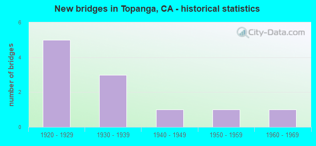
- New bridges - historical statistics
- 51920-1929
- 31930-1939
- 11940-1949
- 11950-1959
- 11960-1969

- Reconstructed bridges - Historical Statistics
- 11950-1959
- 51960-1969
- 01970-1979
- 11980-1989


- Bridge Condition - Deck
- 9.1%Very good
- 72.7%Good
- 18.2%Fair

- Bridge Condition - Superstructure
- 9.1%Very good
- 54.5%Good
- 27.3%Fair
- 9.1%Poor

- Bridge Condition - Substructure
- 36.4%Good
- 9.1%Satisfactory
- 36.4%Fair
- 18.2%Poor

- Bridge Condition - Channel
- 9.1%Excellent
- 9.1%Very good
- 9.1%Good
- 45.5%Satisfactory
- 9.1%Fair
- 18.2%Poor
Find on map >> Show street view
Structure Number: 53 0144, Location: 07-LA-027-4.20 (Lat: 34.088719, Lng: -118.602511), Route carried "on" structure: State highway 27, Year Built: 1934, Status: Open, Structure Length: 4.21m (13.81ft), Average Daily Traffic: 15,050 (year 2014), Truck Traffic: 3%, Average Future Daily Traffic: 19,062 (year 2037), Design Load: HS 15, Features Intersected: TOPANGA CREEK
Minimum Vertical Clearance: 30+ m (98+ ft), Kilometerpoint: 4.200, Lanes on structure: 2, Base Highway Network: Yes (, Subroute: 1), Owner: State Highway Agency, Approaching Roadway Width: 9.1m (29.9ft), Skew: 3 degrees, Material/Design: Concrete, Design/Construction: Arch - Deck, Number Of Spans In Main Unit: 3, Length of Maximum Span: 21.3m (69.9ft), Curb or Sidewalk Widths: Left: 0.6m (2.0ft), Right: 0.6m (2.0ft), Curb-To-Curb Width: 9.1m (29.9ft), Out-to-Out Width: 11.0m (36.1ft)
Condition: Deck: Good, Superstructure: Good, Substructure: Good, Channel: Good, Operating Rating: 94.9 metric tons, Method Used To Determine Operating Rating: Load Factor (LF), Inventory Rating: 57.0 metric tons, Method Used To Determine Inventory Rating: Load Factor (LF), Structural Evaluation: Better than present minimum criteria, Deck Geometry: High priority of corrective action, Waterway Adequacy: Equal to present desirable criteria, Approach Roadway Alignment: Equal to present desirable criteria, Designated Inspection Frequency: Every 48 months, Inspection Date: Febuary 2020, Deck Structure Type: Concrete Cast-file-Place, Wearing Surface/Protective System: Wearing Surface: Bituminous
Find on map >> Show street view
Structure Number: 53 0407, Location: 07-LA-027-6.56 (Lat: 34.113092, Lng: -118.590475), Route carried "on" structure: State highway 27, Year Built: 1927, Year Reconstructed: 1989, Status: Open, Structure Length: 1.42m (4.66ft), Average Daily Traffic: 15,650 (year 2014), Truck Traffic: 3%, Average Future Daily Traffic: 19,887 (year 2037), Design Load: HS 20, Features Intersected: GARAPITO CREEK
Minimum Vertical Clearance: 30+ m (98+ ft), Kilometerpoint: 6.560, Lanes on structure: 2, Base Highway Network: Yes (, Subroute: 1), Owner: State Highway Agency, Approaching Roadway Width: 12.2m (40.0ft), Skew: 2 degrees, Material/Design: Concrete, Design/Construction: Arch - Thru, Number Of Spans In Main Unit: 1, Length of Maximum Span: 14.2m (46.6ft), Curb or Sidewalk Widths: Left: 0.0m, Right: 0.3m (1.0ft), Curb-To-Curb Width: 12.1m (39.7ft), Out-to-Out Width: 13.2m (43.3ft)
Condition: Deck: Good, Superstructure: Good, Substructure: Good, Channel: Very good, Operating Rating: 77.4 metric tons, Method Used To Determine Operating Rating: Load Factor (LF), Inventory Rating: 46.3 metric tons, Method Used To Determine Inventory Rating: Load Factor (LF), Structural Evaluation: Better than present minimum criteria, Deck Geometry: Somewhat better than minimum adequacy, Waterway Adequacy: Equal to present desirable criteria, Approach Roadway Alignment: Equal to present desirable criteria, Designated Inspection Frequency: Every 48 months, Inspection Date: Febuary 2020
Find on map >> Show street view
Structure Number: 53C0939, Location: 50FT W/O TOPANGA CYN RD (Lat: 34.089781, Lng: -118.604856), Route carried "on" structure: County highway , Year Built: 1926, Status: Posted for load, Structure Length: 2.44m (8.01ft), Average Daily Traffic: 3,900 (year 2012), Average Future Daily Traffic: 4,300 (year 2041), Features Intersected: TOPANGA CYN CRK, Facility Carried by Structure: OLD TOPANGA CYN RD
Minimum Vertical Clearance: 5.79m (19.00ft), Kilometerpoint: 0.000, Lanes on structure: 2, Owner: County Highway Agency, Approaching Roadway Width: 8.4m (27.6ft), Skew: 2 degrees, Material/Design: Wood or Timber, Design/Construction: Truss - Thru, Number Of Spans In Main Unit: 2, Length of Maximum Span: 11.6m (38.1ft), Curb-To-Curb Width: 8.4m (27.6ft), Out-to-Out Width: 8.7m (28.5ft)
Condition: Deck: Good, Superstructure: Poor, Substructure: Fair, Channel: Poor, Operating Rating: 12.0 metric tons, Method Used To Determine Operating Rating: Allowable Stress (AS), Inventory Rating: 3.9 metric tons, Method Used To Determine Inventory Rating: Allowable Stress (AS), Structural Evaluation: High priority of replacement, Deck Geometry: High priority of corrective action, Waterway Adequacy: Better than present minimum criteria, Approach Roadway Alignment: Better than present minimum criteria, Bridge Posting: Required (Relationship of Operating Rating to Maximum Legal Load: > 39.9% below), Length Of Structure Improvement: 2.44m (8.01ft), Designated Inspection Frequency: Every 24 months, Critical Feature Inspection Frequency: Every 24 months, Inspection Date: March 2020, Critical Feature Inspection Date: April 2020, Bridge Improvement Cost: $487,000, Deck Structure Type: Wood or Timber, Wearing Surface/Protective System: Wearing Surface: Bituminous
Find on map >> Show street view
Structure Number: 53C0963, Location: 300FT S/O TOPANGA SKY DR (Lat: 34.107025, Lng: -118.629131), Route carried "on" structure: County highway , Year Built: 1927, Year Reconstructed: 1960, Status: Open, Structure Length: 0.76m (2.49ft), Average Daily Traffic: 2,300 (year 2011), Truck Traffic: 2%, Average Future Daily Traffic: 2,900 (year 2041), Features Intersected: OLD TOPANGA CRK, Facility Carried by Structure: OLD TOPANGA CYN RD
Minimum Vertical Clearance: 30.47m (99.97ft), Kilometerpoint: 0.000, Lanes on structure: 2, Owner: County Highway Agency, Approaching Roadway Width: 8.2m (26.9ft), Skew: 1 degrees, Material/Design: Wood or Timber, Design/Construction: Stringer/Multi-beam, Number Of Spans In Main Unit: 1, Length of Maximum Span: 7.0m (23.0ft), Curb-To-Curb Width: 8.2m (26.9ft), Out-to-Out Width: 8.8m (28.9ft)
Condition: Deck: Good, Superstructure: Good, Substructure: Fair, Channel: Satisfactory, Operating Rating: 55.4 metric tons, Method Used To Determine Operating Rating: Allowable Stress (AS), Inventory Rating: 39.9 metric tons, Method Used To Determine Inventory Rating: Allowable Stress (AS), Structural Evaluation: Somewhat better than minimum adequacy, Deck Geometry: High priority of corrective action, Waterway Adequacy: Better than present minimum criteria, Approach Roadway Alignment: Equal to present desirable criteria, Designated Inspection Frequency: Every 24 months, Inspection Date: March 2021, Deck Structure Type: Wood or Timber, Wearing Surface/Protective System: Wearing Surface: Bituminous
Find on map >> Show street view
Structure Number: 53C0966, Location: 400FT N/O TOPANGA SKY DR (Lat: 34.108475, Lng: -118.629131), Route carried "on" structure: County highway , Year Built: 1928, Year Reconstructed: 1960, Status: Open, Structure Length: 0.74m (2.43ft), Average Daily Traffic: 2,300 (year 2011), Truck Traffic: 2%, Average Future Daily Traffic: 2,900 (year 2041), Features Intersected: OLD TOPANGA CRK, Facility Carried by Structure: OLD TPNG CN RD N/C
Minimum Vertical Clearance: 30.47m (99.97ft), Kilometerpoint: 0.000, Lanes on structure: 2, Owner: County Highway Agency, Approaching Roadway Width: 8.4m (27.6ft), Skew: 3 degrees, Material/Design: Wood or Timber, Design/Construction: Stringer/Multi-beam, Number Of Spans In Main Unit: 1, Length of Maximum Span: 6.1m (20.0ft), Curb-To-Curb Width: 8.3m (27.2ft), Out-to-Out Width: 8.7m (28.5ft)
Condition: Deck: Fair, Superstructure: Fair, Substructure: Fair, Channel: Satisfactory, Operating Rating: 53.1 metric tons, Method Used To Determine Operating Rating: Allowable Stress (AS), Inventory Rating: 38.6 metric tons, Method Used To Determine Inventory Rating: Allowable Stress (AS), Structural Evaluation: Somewhat better than minimum adequacy, Deck Geometry: High priority of corrective action, Waterway Adequacy: Meets minimum limits, Approach Roadway Alignment: Better than present minimum criteria, Designated Inspection Frequency: Every 24 months, Inspection Date: March 2021, Deck Structure Type: Wood or Timber, Wearing Surface/Protective System: Wearing Surface: Bituminous
Find on map >> Show street view
Structure Number: 53C0968, Location: 0.1MI N/O OLD TOPANGA RD (Lat: 34.110719, Lng: -118.628983), Route carried "on" structure: County highway , Year Built: 1928, Year Reconstructed: 1967, Status: Open, Structure Length: 0.69m (2.26ft), Average Daily Traffic: 870 (year 2014), Truck Traffic: 1%, Average Future Daily Traffic: 1,040 (year 2041), Features Intersected: OLD TOPANGA CRK, Facility Carried by Structure: OAK DR
Minimum Vertical Clearance: 30.47m (99.97ft), Kilometerpoint: 0.000, Lanes on structure: 2, Owner: County Highway Agency, Approaching Roadway Width: 8.6m (28.2ft), Skew: 2 degrees, Material/Design: Wood or Timber, Design/Construction: Stringer/Multi-beam, Number Of Spans In Main Unit: 1, Length of Maximum Span: 6.4m (21.0ft), Curb-To-Curb Width: 8.6m (28.2ft), Out-to-Out Width: 8.8m (28.9ft)
Condition: Deck: Good, Superstructure: Good, Substructure: Poor, Channel: Satisfactory, Operating Rating: 32.4 metric tons, Method Used To Determine Operating Rating: Allowable Stress (AS), Inventory Rating: 24.0 metric tons, Method Used To Determine Inventory Rating: Allowable Stress (AS), Structural Evaluation: Meets minimum limits, Deck Geometry: Somewhat better than minimum adequacy, Waterway Adequacy: Meets minimum limits, Approach Roadway Alignment: Better than present minimum criteria, Designated Inspection Frequency: Every 24 months, Inspection Date: March 2021, Bridge Improvement Cost: $140,000, Roadway Improvement Cost: $28,000, Total Project Cost: $235,000 ( Estimate for 2019), Deck Structure Type: Wood or Timber, Wearing Surface/Protective System: Wearing Surface: Bituminous
Find on map >> Show street view
Structure Number: 53C0979, Location: 1.9MI N/O TOPANGA CYN BL (Lat: 34.111639, Lng: -118.633731), Route carried "on" structure: County highway , Year Built: 1936, Year Reconstructed: 1960, Status: Posted for load, Structure Length: 0.85m (2.79ft), Average Daily Traffic: 2,712 (year 2012), Truck Traffic: 2%, Average Future Daily Traffic: 2,983 (year 2041), Features Intersected: RED ROCK CRK, Facility Carried by Structure: OLD TOPANGA CYN RD
Minimum Vertical Clearance: 30.47m (99.97ft), Kilometerpoint: 0.000, Lanes on structure: 2, Owner: County Highway Agency, Approaching Roadway Width: 6.9m (22.6ft), Material/Design: Wood or Timber, Design/Construction: Stringer/Multi-beam, Number Of Spans In Main Unit: 1, Length of Maximum Span: 7.6m (24.9ft), Curb-To-Curb Width: 8.3m (27.2ft), Out-to-Out Width: 8.9m (29.2ft)
Condition: Deck: Good, Superstructure: Good, Substructure: Poor, Channel: Satisfactory, Operating Rating: 13.6 metric tons, Method Used To Determine Operating Rating: Allowable Stress (AS), Inventory Rating: 8.1 metric tons, Method Used To Determine Inventory Rating: Allowable Stress (AS), Structural Evaluation: High priority of replacement, Deck Geometry: High priority of corrective action, Waterway Adequacy: Somewhat better than minimum adequacy, Approach Roadway Alignment: Somewhat better than minimum adequacy, Bridge Posting: Required (Relationship of Operating Rating to Maximum Legal Load: > 39.9% below), Designated Inspection Frequency: Every 24 months, Inspection Date: March 2021, Bridge Improvement Cost: $173,000, Roadway Improvement Cost: $34,000, Total Project Cost: $290,000 ( Estimate for 2017), Deck Structure Type: Wood or Timber, Wearing Surface/Protective System: Wearing Surface: Bituminous
Find on map >> Show street view
Structure Number: 53C0981, Location: 0.3MI W/O TOPANGA CYN BL (Lat: 34.092964, Lng: -118.609061), Route carried "on" structure: County highway , Year Built: 1937, Year Reconstructed: 1963, Status: Open, Structure Length: 1.62m (5.31ft), Average Daily Traffic: 2,712 (year 2012), Average Future Daily Traffic: 2,983 (year 2041), Features Intersected: OLD TOPANGA CRK, Facility Carried by Structure: OLD TPNG CN RD E/C
Minimum Vertical Clearance: 30.47m (99.97ft), Kilometerpoint: 0.000, Lanes on structure: 2, Owner: County Highway Agency, Approaching Roadway Width: 7.0m (23.0ft), Skew: 4 degrees, Material/Design: Steel, Design/Construction: Stringer/Multi-beam, Number Of Spans In Main Unit: 1, Length of Maximum Span: 14.6m (47.9ft), Curb-To-Curb Width: 8.6m (28.2ft), Out-to-Out Width: 9.6m (31.5ft)
Condition: Deck: Good, Superstructure: Fair, Substructure: Fair, Channel: Satisfactory, Operating Rating: 35.0 metric tons, Method Used To Determine Operating Rating: Load Factor (LF), Inventory Rating: 21.1 metric tons, Method Used To Determine Inventory Rating: Load Factor (LF), Structural Evaluation: Somewhat better than minimum adequacy, Deck Geometry: Meets minimum limits, Waterway Adequacy: Equal to present minimum criteria, Approach Roadway Alignment: Equal to present minimum criteria, Designated Inspection Frequency: Every 24 months, Other Special Inspection Frequency: Every 48 months, Inspection Date: March 2021, Other Special Inspection Date: December 2021, Deck Structure Type: Concrete Cast-file-Place
Find on map >> Show street view
Structure Number: 53C0995, Location: 0.4MI W/O TOPANGA CYN BL (Lat: 34.099197, Lng: -118.605181), Route carried "on" structure: County highway , Year Built: 1942, Year Reconstructed: 1966, Status: Open, Structure Length: 1.22m (4.00ft), Average Daily Traffic: 204 (year 2012), Average Future Daily Traffic: 204 (year 2041), Design Load: H 20, Features Intersected: GREENLEAF CYN CRK, Facility Carried by Structure: GREENLEAF CYN RD
Minimum Vertical Clearance: 30.47m (99.97ft), Kilometerpoint: 0.000, Lanes on structure: 1, Owner: County Highway Agency, Approaching Roadway Width: 4.0m (13.1ft), Material/Design: Wood or Timber, Design/Construction: Stringer/Multi-beam, Number Of Spans In Main Unit: 3, Length of Maximum Span: 4.0m (13.1ft), Curb-To-Curb Width: 3.6m (11.8ft), Out-to-Out Width: 4.0m (13.1ft)
Condition: Deck: Good, Superstructure: Good, Substructure: Good, Channel: Fair, Operating Rating: 42.4 metric tons, Method Used To Determine Operating Rating: Allowable Stress (AS), Inventory Rating: 30.8 metric tons, Method Used To Determine Inventory Rating: Allowable Stress (AS), Structural Evaluation: Better than present minimum criteria, Deck Geometry: High priority of replacement, Waterway Adequacy: Equal to present desirable criteria, Approach Roadway Alignment: Equal to present minimum criteria, Designated Inspection Frequency: Every 24 months, Critical Feature Inspection Frequency: Every 24 months, Inspection Date: April 2021, Critical Feature Inspection Date: April 2020, Deck Structure Type: Wood or Timber, Wearing Surface/Protective System: Wearing Surface: Bituminous
Find on map >> Show street view
Structure Number: 53C1023, Location: 25FT W/O TOPANGA CYN BLVD (Lat: 34.091231, Lng: -118.602117), Route carried "on" structure: County highway , Year Built: 1953, Status: Open, Structure Length: 1.70m (5.58ft), Average Daily Traffic: 765 (year 2012), Average Future Daily Traffic: 842 (year 2041), Design Load: H 20, Features Intersected: GARAPITO CRK, Facility Carried by Structure: TOPANGA SCHOOL RD
Minimum Vertical Clearance: 30.47m (99.97ft), Kilometerpoint: 0.000, Lanes on structure: 2, Owner: Local Agency, Approaching Roadway Width: 7.9m (25.9ft), Material/Design: Concrete, Design/Construction: Slab, Number Of Spans In Main Unit: 1, Length of Maximum Span: 14.9m (48.9ft), Curb or Sidewalk Widths: Left: 1.6m (5.2ft), Right: 1.6m (5.2ft), Curb-To-Curb Width: 7.9m (25.9ft), Out-to-Out Width: 11.5m (37.7ft)
Condition: Deck: Fair, Superstructure: Fair, Substructure: Good, Channel: Poor, Operating Rating: 69.3 metric tons, Method Used To Determine Operating Rating: Load Factor (LF), Inventory Rating: 41.5 metric tons, Method Used To Determine Inventory Rating: Load Factor (LF), Structural Evaluation: Somewhat better than minimum adequacy, Deck Geometry: Somewhat better than minimum adequacy, Waterway Adequacy: Better than present minimum criteria, Approach Roadway Alignment: Better than present minimum criteria, Designated Inspection Frequency: Every 24 months, Inspection Date: March 2021, Deck Structure Type: Concrete Cast-file-Place
Find on map >> Show street view
Structure Number: 53C1525, Location: 50FT W/O TOPANGA CYN BLVD (Lat: 34.094828, Lng: -118.601986), Route carried "on" structure: County highway , Year Built: 1968, Status: Open, Structure Length: 1.77m (5.81ft), Average Daily Traffic: 306 (year 2012), Average Future Daily Traffic: 306 (year 2039), Design Load: H 20, Features Intersected: TOPANGA CYN CRK, Facility Carried by Structure: GREENLEAF CYN RD
Minimum Vertical Clearance: 30.47m (99.97ft), Kilometerpoint: 0.000, Lanes on structure: 2, Owner: County Highway Agency, Approaching Roadway Width: 9.1m (29.9ft), Material/Design: Concrete continuous, Design/Construction: Slab, Number Of Spans In Main Unit: 2, Length of Maximum Span: 8.5m (27.9ft), Curb-To-Curb Width: 8.9m (29.2ft), Out-to-Out Width: 9.1m (29.9ft)
Condition: Deck: Very good, Superstructure: Very good, Substructure: Satisfactory, Channel: Excellent, Operating Rating: 59.0 metric tons, Method Used To Determine Operating Rating: Load Factor (LF), Inventory Rating: 35.3 metric tons, Method Used To Determine Inventory Rating: Load Factor (LF), Structural Evaluation: Equal to present minimum criteria, Deck Geometry: Equal to present minimum criteria, Waterway Adequacy: Better than present minimum criteria, Approach Roadway Alignment: Better than present minimum criteria, Designated Inspection Frequency: Every 48 months, Inspection Date: April 2019, Deck Structure Type: Concrete Cast-file-Place, Wearing Surface/Protective System: Wearing Surface: Epoxy Overlay