Bridge Statistics for Woodbourne-Hyde Park, Ohio (OH)
Condition, Traffic, Stress, Structural Evaluation, Project Costs
- National Bridge Inventory (NBI) Statistics
- 10Number of bridges
- 89ft / 27.2mTotal length
- 201,306Total average daily traffic
- 10,154Total average daily truck traffic
- National Bridge Inventory (NBI) Registered Bridges for Woodbourne-Hyde Park
- No street view available for this location
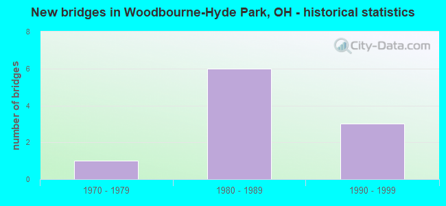
- New bridges - historical statistics
- 11970-1979
- 61980-1989
- 31990-1999


- Bridge Condition - Deck
- 50.0%Very good
- 33.3%Good
- 16.7%Satisfactory

- Bridge Condition - Superstructure
- 66.7%Very good
- 16.7%Good
- 16.7%Satisfactory

- Bridge Condition - Substructure
- 66.7%Very good
- 33.3%Good

- Bridge Condition - Channel
- 33.3%Excellent
- 33.3%Very good
- 16.7%Good
- 16.7%Satisfactory
Find on map >> Show street view
Structure Number: 5703581, Location: JCT. IR-675 (Lat: 39.645950, Lng: -84.157469), Route carried "on" structure: State highway 48, Year Built: 1985, Status: Open, Structure Length: 9.94m (32.61ft), Average Daily Traffic: 38,712 (year 2015), Truck Traffic: 3%, Average Future Daily Traffic: 53,732 (year 2035), Design Load: HS 20+Mod, Features Intersected: RAMP=I675*E-S48*N I675
Minimum Vertical Clearance: 30+ m (98+ ft), Kilometerpoint: 7.210, Lanes on structure: 6, Lanes under structure: 7, Base Highway Network: Yes, Owner: State Highway Agency, Approaching Roadway Width: 22.3m (73.2ft), Skew: 2 degrees, Material/Design: Steel continuous, Design/Construction: Stringer/Multi-beam, Number Of Spans In Main Unit: 4, Length of Maximum Span: 27.4m (89.9ft), Curb-To-Curb Width: 31.3m (102.7ft), Out-to-Out Width: 32.0m (105.0ft)
Condition: Deck: Very good, Superstructure: Good, Substructure: Good, Operating Rating: 61.6 metric tons, Method Used To Determine Operating Rating: Load and Resistance Factor Rating (LRFR) rating reported by rating factor(RF) method using HL-93 loadings, Inventory Rating: 48.6 metric tons, Method Used To Determine Inventory Rating: Load and Resistance Factor Rating (LRFR) rating reported by rating factor(RF) method using HL-93 loadings, Structural Evaluation: Better than present minimum criteria, Deck Geometry: Superior to present desirable criteria, Underclear: Somewhat better than minimum adequacy, Approach Roadway Alignment: Superior to present desirable criteria, Designated Inspection Frequency: Every 24 months, Inspection Date: August 2021, Deck Structure Type: Concrete Cast-file-Place, Wearing Surface/Protective System: Wearing Surface: Monolithic Concrete
Find on map >> Show street view
Structure Number: 5711266, Location: .69MI W OF JCT SR48 (Lat: 39.640331, Lng: -84.167661), Route carried "on" structure: Interstate 675, Year Built: 1985, Status: Open, Structure Length: 6.10m (20.01ft), Average Daily Traffic: 38,296 (year 2015), Truck Traffic: 6%, Average Future Daily Traffic: 53,155 (year 2035), Design Load: HS 20+Mod, Features Intersected: T141(N LA) TRIB HOLES CR
Minimum Vertical Clearance: 30+ m (98+ ft), Kilometerpoint: 6.614, Lanes on structure: 3, Lanes under structure: 3, Base Highway Network: Yes, Owner: State Highway Agency, Approaching Roadway Width: 18.3m (60.0ft), Skew: 3 degrees, Material/Design: Steel, Design/Construction: Stringer/Multi-beam, Number Of Spans In Main Unit: 1, Length of Maximum Span: 58.8m (192.9ft), Curb-To-Curb Width: 19.6m (64.3ft), Out-to-Out Width: 20.1m (65.9ft)
Condition: Deck: Good, Superstructure: Very good, Substructure: Very good, Channel: Excellent, Operating Rating: 97.2 metric tons, Method Used To Determine Operating Rating: Load Factor (LF) rating reported by rating factor (RF) method using MS18 loading, Inventory Rating: 61.6 metric tons, Method Used To Determine Inventory Rating: Load Factor (LF) rating reported by rating factor (RF) method using MS18 loading, Structural Evaluation: Equal to present desirable criteria, Deck Geometry: Superior to present desirable criteria, Underclear: Equal to present minimum criteria, Waterway Adequacy: Superior to present desirable criteria, Approach Roadway Alignment: Superior to present desirable criteria, Designated Inspection Frequency: Every 24 months, Inspection Date: August 2021, Deck Structure Type: Concrete Cast-file-Place, Wearing Surface/Protective System: Wearing Surface: Monolithic Concrete
Find on map >> Show street view
Structure Number: 5711274, Location: .69MI W OF JCT SR48 (Lat: 39.640631, Lng: -84.167761), Route carried "on" structure: Interstate 675, Year Built: 1985, Status: Open, Structure Length: 5.76m (18.90ft), Average Daily Traffic: 38,296 (year 2015), Truck Traffic: 6%, Average Future Daily Traffic: 53,155 (year 2035), Design Load: HS 20+Mod, Features Intersected: T141(N LA) TRIB HOLES CR
Minimum Vertical Clearance: 30+ m (98+ ft), Kilometerpoint: 6.614, Lanes on structure: 3, Lanes under structure: 3, Base Highway Network: Yes, Owner: State Highway Agency, Approaching Roadway Width: 16.5m (54.1ft), Skew: 3 degrees, Material/Design: Steel, Design/Construction: Stringer/Multi-beam, Number Of Spans In Main Unit: 1, Length of Maximum Span: 55.5m (182.1ft), Curb-To-Curb Width: 16.5m (54.1ft), Out-to-Out Width: 17.0m (55.8ft)
Condition: Deck: Good, Superstructure: Very good, Substructure: Very good, Channel: Excellent, Operating Rating: 97.2 metric tons, Method Used To Determine Operating Rating: Load Factor (LF) rating reported by rating factor (RF) method using MS18 loading, Inventory Rating: 64.8 metric tons, Method Used To Determine Inventory Rating: Load Factor (LF) rating reported by rating factor (RF) method using MS18 loading, Structural Evaluation: Equal to present desirable criteria, Deck Geometry: Equal to present minimum criteria, Underclear: Equal to present minimum criteria, Waterway Adequacy: Superior to present desirable criteria, Approach Roadway Alignment: Superior to present desirable criteria, Designated Inspection Frequency: Every 24 months, Inspection Date: August 2021, Deck Structure Type: Concrete Cast-file-Place, Wearing Surface/Protective System: Wearing Surface: Monolithic Concrete
Find on map >> Show street view
Structure Number: 5752175, Location: AT ALEX BELL ROAD (Lat: 39.650950, Lng: -84.186250), Route carried "on" structure: County highway T0139, Year Built: 1993, Status: Open, Structure Length: 2.87m (9.42ft), Average Daily Traffic: 7,606 (year 2015), Truck Traffic: 1%, Average Future Daily Traffic: 10,557 (year 2035), Design Load: HS 25 or greater, Features Intersected: HOLES CREEK
Minimum Vertical Clearance: 30+ m (98+ ft), Kilometerpoint: 2.575, Lanes on structure: 3, Owner: County Highway Agency, Approaching Roadway Width: 11.0m (36.1ft), Material/Design: Concrete continuous, Design/Construction: Slab, Number Of Spans In Main Unit: 3, Length of Maximum Span: 10.7m (35.1ft), Curb or Sidewalk Widths: Left: 0.0m, Right: 1.8m (5.9ft), Curb-To-Curb Width: 11.9m (39.0ft), Out-to-Out Width: 14.6m (47.9ft)
Condition: Deck: Very good, Superstructure: Very good, Substructure: Very good, Channel: Very good, Operating Rating: 81.0 metric tons, Method Used To Determine Operating Rating: Load Factor (LF) rating reported by rating factor (RF) method using MS18 loading, Inventory Rating: 48.6 metric tons, Method Used To Determine Inventory Rating: Load Factor (LF) rating reported by rating factor (RF) method using MS18 loading, Structural Evaluation: Equal to present desirable criteria, Deck Geometry: High priority of corrective action, Waterway Adequacy: Superior to present desirable criteria, Approach Roadway Alignment: Equal to present desirable criteria, Designated Inspection Frequency: Every 24 months, Inspection Date: December 2021, Deck Structure Type: Concrete Cast-file-Place, Wearing Surface/Protective System: Wearing Surface: Integral Concrete, Membrane: Epoxy, Deck Protection: Epoxy Coated Reinforcing
Find on map >> Show street view
Structure Number: 5752264, Location: 1.7 MI WEST OF SR48 (Lat: 39.665850, Lng: -84.193439), Route carried "on" structure: County highway T0076, Year Built: 1991, Status: Open, Structure Length: 0.85m (2.79ft), Average Daily Traffic: 3,908 (year 2015), Truck Traffic: 1%, Average Future Daily Traffic: 5,424 (year 2035), Design Load: HS 25 or greater, Features Intersected: TRIBUTARY HOLES CREEK, Facility Carried by Structure: RAHN RD TWP RD 76
Minimum Vertical Clearance: 30+ m (98+ ft), Kilometerpoint: 0.612, Lanes on structure: 2, Owner: County Highway Agency, Approaching Roadway Width: 6.1m (20.0ft), Skew: 4 degrees, Material/Design: Concrete, Design/Construction: Frame, Number Of Spans In Main Unit: 1, Length of Maximum Span: 7.9m (25.9ft), Curb-To-Curb Width: 8.8m (28.9ft), Out-to-Out Width: 18.4m (60.4ft)
Condition: Deck: Very good, Superstructure: Very good, Substructure: Very good, Channel: Good, Operating Rating: 82.6 metric tons, Method Used To Determine Operating Rating: Load Factor (LF) rating reported by rating factor (RF) method using MS18 loading, Inventory Rating: 49.6 metric tons, Method Used To Determine Inventory Rating: Load Factor (LF) rating reported by rating factor (RF) method using MS18 loading, Structural Evaluation: Equal to present desirable criteria, Deck Geometry: Meets minimum limits, Waterway Adequacy: Equal to present desirable criteria, Approach Roadway Alignment: Equal to present desirable criteria, Designated Inspection Frequency: Every 24 months, Inspection Date: November 2021, Deck Structure Type: Concrete Cast-file-Place, Wearing Surface/Protective System: Wearing Surface: Bituminous
Find on map >> Show street view
Structure Number: 5752396, Location: .3 MILE WEST OF SR48 (Lat: 39.654839, Lng: -84.164239), Route carried "on" structure: County highway T2606, Year Built: 1973, Status: Open, Structure Length: 0.88m (2.89ft), Average Daily Traffic: 681 (year 2018), Truck Traffic: 1%, Average Future Daily Traffic: 931 (year 2038), Design Load: H 20, Features Intersected: trib to Holes Creek
Minimum Vertical Clearance: 30+ m (98+ ft), Kilometerpoint: 0.097, Lanes on structure: 2, Owner: County Highway Agency, Approaching Roadway Width: 6.1m (20.0ft), Material/Design: Concrete, Design/Construction: Slab, Number Of Spans In Main Unit: 1, Length of Maximum Span: 7.9m (25.9ft), Curb or Sidewalk Widths: Left: 1.8m (5.9ft), Right: 1.8m (5.9ft), Curb-To-Curb Width: 7.9m (25.9ft), Out-to-Out Width: 11.6m (38.1ft)
Condition: Deck: Satisfactory, Superstructure: Satisfactory, Substructure: Good, Channel: Satisfactory, Operating Rating: 79.7 metric tons, Method Used To Determine Operating Rating: Load Factor (LF) rating reported by rating factor (RF) method using MS18 loading, Inventory Rating: 48.0 metric tons, Method Used To Determine Inventory Rating: Load Factor (LF) rating reported by rating factor (RF) method using MS18 loading, Structural Evaluation: Equal to present minimum criteria, Deck Geometry: Somewhat better than minimum adequacy, Waterway Adequacy: Equal to present desirable criteria, Approach Roadway Alignment: Equal to present desirable criteria, Designated Inspection Frequency: Every 12 months, Inspection Date: November 2021, Deck Structure Type: Concrete Cast-file-Place, Wearing Surface/Protective System: Wearing Surface: Monolithic Concrete
Find on map >> Show street view
Structure Number: 5752779, Location: .3 MILES S OF WHIPP RD. (Lat: 39.655031, Lng: -84.169389), Route carried "on" structure: County highway T2264, Year Built: 1998, Status: Open, Structure Length: 0.76m (2.49ft), Average Daily Traffic: 2,503 (year 2015), Truck Traffic: 2%, Average Future Daily Traffic: 3,474 (year 2035), Design Load: HS 25 or greater, Features Intersected: trib. to Holes Creek, Facility Carried by Structure: Seton Hill Street
Minimum Vertical Clearance: 30+ m (98+ ft), Kilometerpoint: 0.499, Lanes on structure: 2, Owner: County Highway Agency, Approaching Roadway Width: 7.0m (23.0ft), Skew: 2 degrees, Material/Design: Concrete, Design/Construction: Culvert, Number Of Spans In Main Unit: 1, Length of Maximum Span: 7.3m (24.0ft)
Condition: Channel: Very good, Culverts: Good, Operating Rating: 69.0 metric tons, Method Used To Determine Operating Rating: Load Factor (LF) rating reported by rating factor (RF) method using MS18 loading, Inventory Rating: 41.5 metric tons, Method Used To Determine Inventory Rating: Load Factor (LF) rating reported by rating factor (RF) method using MS18 loading, Structural Evaluation: Better than present minimum criteria, Waterway Adequacy: Equal to present desirable criteria, Approach Roadway Alignment: Equal to present desirable criteria, Designated Inspection Frequency: Every 24 months, Inspection Date: November 2021
Find on map >> Show street view
Structure Number: 5703581, Location: JCT. IR-675 (Lat: 39.645950, Lng: -84.157469), Route carried "under" structure: Interstate 675, Year Built: 1985, Structure Length: 0. m, Average Daily Traffic: 66,376 (year 2015), Truck Traffic: 6%, Features Intersected: S48, Facility Carried by Structure: SR-48
Minimum Vertical Clearance: 5.26m (17.26ft), Kilometerpoint: 7.709, Lanes on structure: 6, Lanes under structure: 7, Material/Design: Steel continuous, Design/Construction: Stringer/Multi-beam, Length of Maximum Span: 27.4m (89.9ft)
Find on map >> Show street view
Structure Number: 5711266, Location: .69MI W OF JCT SR48 (Lat: 39.640331, Lng: -84.167661), Route carried "under" structure: County highway T0141, Year Built: 1985, Structure Length: 0. m, Average Daily Traffic: 2,464 (year 2015), Truck Traffic: 5%, Features Intersected: I675, Facility Carried by Structure: SB IR675
Minimum Vertical Clearance: 4.57m (14.99ft), Kilometerpoint: 0.628, Lanes on structure: 3, Lanes under structure: 3, Material/Design: Steel, Design/Construction: Stringer/Multi-beam, Length of Maximum Span: 58.8m (192.9ft)
Find on map >> Show street view
Structure Number: 5711274, Location: .69MI W OF JCT SR48 (Lat: 39.640631, Lng: -84.167761), Route carried "under" structure: County highway T0141, Year Built: 1985, Structure Length: 0. m, Average Daily Traffic: 2,464 (year 2015), Truck Traffic: 5%, Features Intersected: I675, Facility Carried by Structure: NB IR675
Minimum Vertical Clearance: 4.57m (14.99ft), Kilometerpoint: 0.628, Lanes on structure: 3, Lanes under structure: 3, Material/Design: Steel, Design/Construction: Stringer/Multi-beam, Length of Maximum Span: 55.5m (182.1ft)