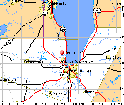
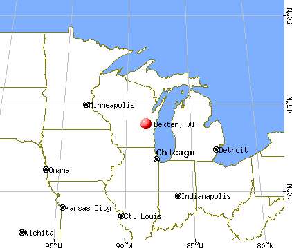
Dexter, Wisconsin
Submit your own pictures of this town and show them to the world
- OSM Map
- General Map
- Google Map
- MSN Map
Population change since 2000: -5.3%
 |
| Males: 195 | |
| Females: 164 |
| Median resident age: | 47.1 years |
| Wisconsin median age: | 42.6 years |
Zip codes: 54466.
| Dexter: | $66,940 |
| WI: | $70,996 |
Estimated per capita income in 2022: $36,606 (it was $19,060 in 2000)
Dexter town income, earnings, and wages data
Estimated median house or condo value in 2022: $163,294 (it was $75,700 in 2000)
| Dexter: | $163,294 |
| WI: | $252,800 |
Mean prices in 2022: all housing units: $219,377; detached houses: $224,329; townhouses or other attached units: $269,376; in 2-unit structures: $142,836; in 3-to-4-unit structures: $222,868; in 5-or-more-unit structures: $787,882; mobile homes: $61,727
Detailed information about poverty and poor residents in Dexter, WI


- 35598.9%White alone
- 30.8%Hispanic
- 10.3%American Indian alone

Races in Dexter detailed stats: ancestries, foreign born residents, place of birth
 Recent articles from our blog. Our writers, many of them Ph.D. graduates or candidates, create easy-to-read articles on a wide variety of topics.

 | Craft Beer Bars in Greater Madison (12 replies) |
| Yet another plea for neighborhood advice from those in the know (12 replies) |
Latest news from Dexter, WI collected exclusively by city-data.com from local newspapers, TV, and radio stations
Ancestries: German (49.6%), Polish (19.5%), Norwegian (12.4%), Irish (4.2%), Dutch (3.7%), English (3.4%).
Current Local Time: CST time zone
Elevation: 775 feet
Land area: 34.2 square miles.
Population density: 10 people per square mile (very low).
5 residents are foreign born
| This town: | 1.3% |
| Wisconsin: | 3.6% |
| Dexter town: | 1.4% ($1,069) |
| Wisconsin: | 2.0% ($2,245) |
Nearest city with pop. 50,000+: La Crosse, WI  (66.4 miles , pop. 51,818).
Nearest city with pop. 200,000+: Madison, WI (97.7 miles , pop. 208,054).
Nearest city with pop. 1,000,000+: Chicago, IL (215.3 miles , pop. 2,896,016).
Nearest cities:
), ), ), ), )Latitude: 44.38 N, Longitude: 90.15 W


Single-family new house construction building permits:
- 2022: 1 building, cost: $300,000
- 2021: 1 building, cost: $55,000
- 2015: 3 buildings, average cost: $136,000
- 2013: 1 building, cost: $200,000
- 2010: 3 buildings, average cost: $119,100
- 2009: 3 buildings, average cost: $120,300
- 2008: 1 building, cost: $299,000
- 2007: 2 buildings, average cost: $150,000
- 2006: 1 building, cost: $62,000
- 2005: 2 buildings, average cost: $42,000
- 2004: 2 buildings, average cost: $100,000
- 2003: 2 buildings, average cost: $82,500
- 2002: 2 buildings, average cost: $82,500


| Here: | 3.4% |
| Wisconsin: | 2.7% |

- Agriculture, forestry, fishing & hunting (19.4%)
- Paper (11.1%)
- Health care (10.0%)
- Construction (7.2%)
- Finance & insurance (5.0%)
- Wood products (3.9%)
- Educational services (3.9%)

- Agriculture, forestry, fishing & hunting (28.0%)
- Paper (16.0%)
- Construction (8.0%)
- Wood products (7.0%)
- Repair & maintenance (6.0%)
- Machinery (5.0%)
- Farm supplies merchant wholesalers (5.0%)

- Health care (17.5%)
- Finance & insurance (11.2%)
- Agriculture, forestry, fishing & hunting (8.8%)
- Educational services (8.8%)
- Arts, entertainment, recreation (8.8%)
- Construction (6.2%)
- Paper (5.0%)

- Farmers and farm managers (8.9%)
- Laborers and material movers, hand (7.2%)
- Other production occupations, including supervisors (7.2%)
- Other sales and related occupations, including supervisors (5.6%)
- Metal workers and plastic workers (4.4%)
- Agricultural workers, including supervisors (4.4%)
- Secretaries and administrative assistants (4.4%)

- Farmers and farm managers (14.0%)
- Other production occupations, including supervisors (13.0%)
- Laborers and material movers, hand (12.0%)
- Metal workers and plastic workers (8.0%)
- Other sales and related occupations, including supervisors (4.0%)
- Fishing, hunting, and forestry occupations (4.0%)
- Engineers (3.0%)

- Secretaries and administrative assistants (10.0%)
- Financial clerks, except bookkeeping, accounting and auditing clerks (7.5%)
- Other sales and related occupations, including supervisors (7.5%)
- Agricultural workers, including supervisors (6.2%)
- Bookkeeping, accounting, and auditing clerks (5.0%)
- Registered nurses (5.0%)
- Food and beverage serving workers, except waiters and waitresses (5.0%)
Average climate in Dexter, Wisconsin
Based on data reported by over 4,000 weather stations


(lower is better)

Air Quality Index (AQI) level in 2001 was 25.9. This is significantly better than average.
| City: | 25.9 |
| U.S.: | 72.6 |

Sulfur Dioxide (SO2) [ppb] level in 2001 was 3.05. This is significantly worse than average. Closest monitor was 14.4 miles away from the city center.
| City: | 3.05 |
| U.S.: | 1.51 |

Tornado activity:
Dexter-area historical tornado activity is near Wisconsin state average. It is 20% greater than the overall U.S. average.
On 4/19/1957, a category F4 (max. wind speeds 207-260 mph) tornado 14.8 miles away from the Dexter town center killed one person and caused between $5000 and $50,000 in damages.
On 6/4/1958, a category F4 tornado 36.3 miles away from the town center killed 4 people and injured 3 people and caused between $500,000 and $5,000,000 in damages.
Earthquake activity:
Dexter-area historical earthquake activity is significantly above Wisconsin state average. It is 12% greater than the overall U.S. average.On 6/28/2004 at 06:10:52, a magnitude 4.2 (4.2 MW, Depth: 6.2 mi, Class: Light, Intensity: IV - V) earthquake occurred 211.5 miles away from Dexter center
On 4/18/2008 at 09:36:59, a magnitude 5.4 (5.1 MB, 4.8 MS, 5.4 MW, 5.2 MW, Class: Moderate, Intensity: VI - VII) earthquake occurred 426.3 miles away from the city center
On 7/9/1975 at 14:54:15, a magnitude 4.6 (4.6 MB) earthquake occurred 301.4 miles away from Dexter center
On 6/10/1987 at 23:48:54, a magnitude 5.1 (4.9 MB, 4.4 MS, 4.6 MS, 5.1 LG) earthquake occurred 401.8 miles away from the city center
On 2/10/2010 at 09:59:35, a magnitude 3.8 (3.8 MW, Depth: 6.2 mi, Class: Light, Intensity: II - III) earthquake occurred 186.3 miles away from Dexter center
On 4/18/2008 at 09:36:59, a magnitude 5.2 (5.2 MW, Depth: 8.9 mi) earthquake occurred 426.4 miles away from the city center
Magnitude types: regional Lg-wave magnitude (LG), body-wave magnitude (MB), surface-wave magnitude (MS), moment magnitude (MW)
Natural disasters:
The number of natural disasters in Wood County (12) is smaller than the US average (15).Major Disasters (Presidential) Declared: 9
Emergencies Declared: 2
Causes of natural disasters: Floods: 9, Storms: 7, Tornadoes: 3, Drought: 1, Hurricane: 1, Wind: 1, Other: 1 (Note: some incidents may be assigned to more than one category).

Colleges/universities with over 2000 students nearest to Dexter:
- Mid-State Technical College (about 19 miles; Wisconsin Rapids, WI; Full-time enrollment: 2,128)
- University of Wisconsin-Stevens Point (about 31 miles; Stevens Point, WI; FT enrollment: 9,089)
- Northcentral Technical College (about 49 miles; Wausau, WI; FT enrollment: 3,356)
- University of Wisconsin-La Crosse (about 67 miles; La Crosse, WI; FT enrollment: 9,837)
- Western Technical College (about 67 miles; La Crosse, WI; FT enrollment: 3,377)
- Viterbo University (about 68 miles; La Crosse, WI; FT enrollment: 2,848)
- University of Wisconsin-Eau Claire (about 73 miles; Eau Claire, WI; FT enrollment: 10,143)
Points of interest:
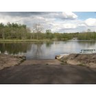
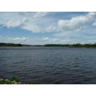
Reservoirs: South Gallagher Flowage (A), Lake Dexter (B), North Gallagher Flowage (C), Lake Dexter 210 (D). Display/hide their locations on the map
Creek: Owl Creek (A). Display/hide its location on the map
Park in Dexter: Dexter County Park (1). Display/hide its location on the map
| This town: | 2.4 people |
| Wisconsin: | 2.4 people |
| This town: | 73.0% |
| Whole state: | 64.4% |
| This town: | 5.3% |
| Whole state: | 7.3% |
Likely homosexual households (counted as self-reported same-sex unmarried-partner households)
- Lesbian couples: 0.7% of all households
- Gay men: 0.0% of all households
| This town: | 4.0% |
| Whole state: | 8.7% |
For population 15 years and over in Dexter:

- Never married: 17.4%
- Now married: 66.8%
- Separated: 1.3%
- Widowed: 7.7%
- Divorced: 6.8%
For population 25 years and over in Dexter:
- High school or higher: 79.6%
- Bachelor's degree or higher: 12.0%
- Graduate or professional degree: 2.9%
- Unemployed: 7.2%
- Mean travel time to work (commute): 27.6 minutes


| Here: | 9.4 |
| Wisconsin average: | 11.0 |
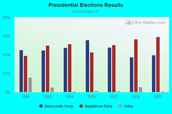
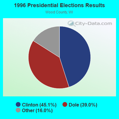
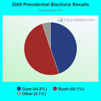
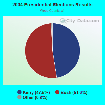
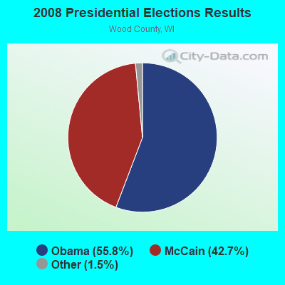
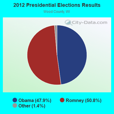
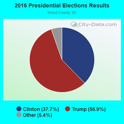
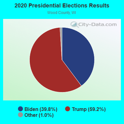
Graphs represent county-level data. Detailed 2008 Election Results
Religion statistics for Dexter, WI (based on Wood County data)
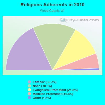
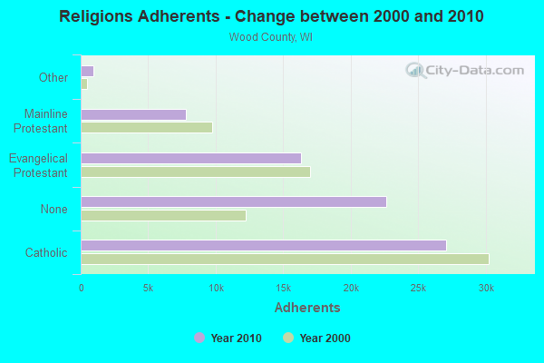
| Religion | Adherents | Congregations |
|---|---|---|
| Catholic | 27,050 | 18 |
| Evangelical Protestant | 16,327 | 51 |
| Mainline Protestant | 7,785 | 25 |
| Other | 973 | 6 |
| None | 22,614 | - |
Food Environment Statistics:
| This county: | 1.22 / 10,000 pop. |
| State: | 1.86 / 10,000 pop. |
| Wood County: | 0.14 / 10,000 pop. |
| Wisconsin: | 0.11 / 10,000 pop. |
| Wood County: | 4.61 / 10,000 pop. |
| Wisconsin: | 4.12 / 10,000 pop. |
| Wood County: | 8.81 / 10,000 pop. |
| Wisconsin: | 8.64 / 10,000 pop. |
| Wood County: | 8.6% |
| State: | 7.6% |
| Wood County: | 28.4% |
| State: | 27.5% |
| Wood County: | 11.3% |
| State: | 13.0% |
Strongest AM radio stations in Dexter:
- WSPT (1010 AM; 50 kW; STEVENS POINT, WI)
- WSAU (550 AM; 20 kW; WAUSAU, WI; Owner: WRIG, INC.)
- WLBL (930 AM; 5 kW; AUBURNDALE, WI; Owner: STATE OF WISCONSIN - EDUCATIONAL COMMUNICATIONS BOARD)
- WFHR (1320 AM; 5 kW; WISCONSIN RAPIDS, WI; Owner: WISCONSIN RAPIDS BROADCASTING, LLC)
- WNAM (1280 AM; 50 kW; NEENAH-MENASHA, WI; Owner: CUMULUS LICENSING CORP.)
- WCCN (1370 AM; 5 kW; NEILLSVILLE, WI; Owner: CENTRAL WISCONSIN BROADCASTING, INC.)
- WRIG (1390 AM; 10 kW; SCHOFIELD, WI; Owner: WRIG, INC.)
- WHBY (1150 AM; 25 kW; KIMBERLY, WI; Owner: WOODWARD COMMUNICATIONS, INC.)
- WTMJ (620 AM; 50 kW; MILWAUKEE, WI; Owner: JOURNAL BROADCAST CORPORATION)
- WEBC (560 AM; 50 kW; DULUTH, MN)
- WCTS (1030 AM; 50 kW; MAPLEWOOD, MN; Owner: CNTL. BAPT. THEO/AL SEMI MINNEAPOLIS)
- WCCO (830 AM; 50 kW; MINNEAPOLIS, MN; Owner: INFINITY MEDIA CORPORATION)
- WDUX (800 AM; 5 kW; WAUPACA, WI; Owner: LAIRD BROADCASTING COMPANY, INC.)
Strongest FM radio stations in Dexter:
- WGLX-FM (103.3 FM; WISCONSIN RAPIDS, WI; Owner: WISCONSIN RAPIDS BROADCASTING, LLC)
- WLJY (106.5 FM; MARSHFIELD, WI; Owner: NEWRADIO GROUP, LLC)
- WAXX (104.5 FM; EAU CLAIRE, WI; Owner: MAVERICK MEDIA OF EAU CLAIRE LICENSE LLC)
- WGNV (88.5 FM; MILLADORE, WI; Owner: EVANGEL MINISTRIES, INC.)
- WVCX (98.9 FM; TOMAH, WI; Owner: VCY AMERICA, INC.)
- WHRM (90.9 FM; WAUSAU, WI; Owner: STATE OF WISCONSIN - EDUCATIONAL COMMUNICATIONS BOARD)
- WDEZ (101.9 FM; WAUSAU, WI; Owner: W R I G, INC.)
- WCCN-FM (107.5 FM; NEILLSVILLE, WI; Owner: CENTRAL WISCONSIN B/CG INC.)
- WIFC (95.5 FM; WAUSAU, WI; Owner: WRIG, INC.)
- WMMA (93.9 FM; NEKOOSA, WI; Owner: STARBOARD BROADCASTING, INC.)
- WYTE (96.7 FM; WHITING, WI; Owner: NEWRADIO GROUP, LLC)
- WIZD (99.9 FM; RUDOLPH, WI; Owner: WRIG, INC)
TV broadcast stations around Dexter:
- W24BV (Channel 24; WHITING, WI; Owner: MS COMMUNICATIONS, LLC)
- WDLS-LP (Channel 35; TOMAH, WI; Owner: MAGNUM RADIO, INC.)
- WEAU-TV (Channel 13; EAU CLAIRE, WI; Owner: WEAU LICENSEE CORP.)
- W60CI (Channel 60; WHITING, WI; Owner: MS COMMUNICATIONS, LLC)
- W16AY (Channel 16; WHITING, WI; Owner: MS COMMUNICATIONS, LLC)
- W18CS (Channel 18; WHITING, WI; Owner: MS COMMUNICATIONS, LLC)
- W40BC (Channel 40; WHITING, WI; Owner: MS COMMUNICATIONS, LLC)
- W62DA (Channel 62; WHITING, WI; Owner: MS COMMUNICATIONS, LLC)
- National Bridge Inventory (NBI) Statistics
- 3Number of bridges
- 10ft / 3.3mTotal length
- 8,000Total average daily traffic
- 880Total average daily truck traffic
- 11,750Total future (year 2040) average daily traffic

- 51.1%Bottled, tank, or LP gas
- 23.7%Wood
- 20.9%Fuel oil, kerosene, etc.
- 2.9%Electricity
- 1.4%Utility gas

- 33.3%Bottled, tank, or LP gas
- 33.3%Fuel oil, kerosene, etc.
- 33.3%Wood
Dexter compared to Wisconsin state average:
- Median house value below state average.
- Unemployed percentage below state average.
- Black race population percentage significantly below state average.
- Hispanic race population percentage significantly below state average.
- Median age above state average.
- Foreign-born population percentage significantly below state average.
- Renting percentage significantly below state average.
- Length of stay since moving in significantly above state average.
- Number of rooms per house significantly below state average.
- House age significantly below state average.
- Number of college students significantly below state average.
- Percentage of population with a bachelor's degree or higher below state average.