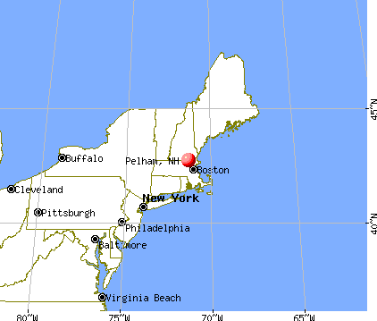
Pelham, New Hampshire
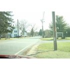
Pelham: This crosswalk leads from the senior center to the funeral home. Comical? Efficient? You be the judge.

Pelham: Panorama of Dear Leap
- add
your
Submit your own pictures of this town and show them to the world
- OSM Map
- General Map
- Google Map
- MSN Map
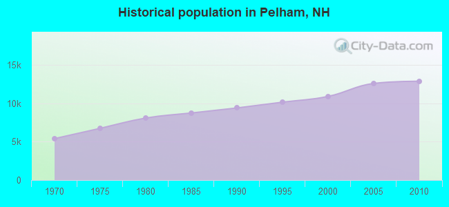
Population change since 2000: +18.2%
 |
| Males: 6,429 | |
| Females: 6,468 |
| Median resident age: | 40.7 years |
| New Hampshire median age: | 43.9 years |
Zip codes: 03076.
| Pelham: | $124,561 |
| NH: | $89,992 |
Estimated per capita income in 2022: $50,172 (it was $25,158 in 2000)
Pelham town income, earnings, and wages data
Estimated median house or condo value in 2022: $520,878 (it was $173,200 in 2000)
| Pelham: | $520,878 |
| NH: | $384,700 |
Mean prices in 2022: all housing units: $411,252; detached houses: $441,251; townhouses or other attached units: $283,002; in 2-unit structures: $347,377; in 3-to-4-unit structures: $666,663; in 5-or-more-unit structures: $275,798; mobile homes: $132,093
Detailed information about poverty and poor residents in Pelham, NH


- 12,20894.7%White alone
- 2431.9%Hispanic
- 2251.7%Asian alone
- 1120.9%Two or more races
- 700.5%Black alone
- 250.2%Other race alone
- 130.1%American Indian alone
- 10.01%Native Hawaiian and Other
Pacific Islander alone
Races in Pelham detailed stats: ancestries, foreign born residents, place of birth
According to our research of New Hampshire and other state lists, there were 10 registered sex offenders living in Pelham, New Hampshire as of June 10, 2024.
The ratio of all residents to sex offenders in Pelham is 1,290 to 1.
The ratio of registered sex offenders to all residents in this city is much lower than the state average.
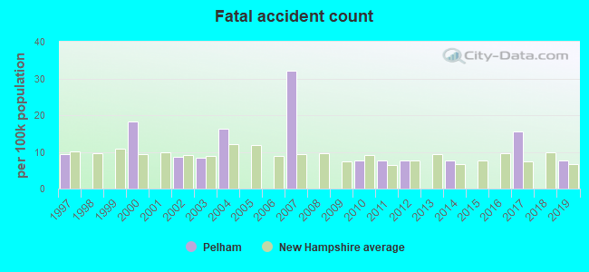
Type |
2009 |
2010 |
2011 |
2012 |
2013 |
2014 |
2015 |
2016 |
2017 |
2018 |
2019 |
2020 |
2021 |
2022 |
|---|---|---|---|---|---|---|---|---|---|---|---|---|---|---|
| Murders (per 100,000) | 0 (0.0) | 0 (0.0) | 1 (7.7) | 0 (0.0) | 0 (0.0) | 0 (0.0) | 0 (0.0) | 0 (0.0) | 0 (0.0) | 0 (0.0) | 0 (0.0) | 0 (0.0) | 0 (0.0) | 0 (0.0) |
| Rapes (per 100,000) | 1 (7.8) | 2 (15.5) | 2 (15.5) | 1 (7.7) | 5 (38.4) | 0 (0.0) | 1 (7.5) | 2 (14.9) | 1 (7.4) | 6 (43.5) | 4 (28.2) | 2 (13.9) | 4 (27.7) | 1 (7.0) |
| Robberies (per 100,000) | 3 (23.5) | 1 (7.8) | 3 (23.2) | 1 (7.7) | 1 (7.7) | 1 (7.6) | 2 (15.0) | 0 (0.0) | 1 (7.4) | 0 (0.0) | 1 (7.0) | 0 (0.0) | 0 (0.0) | 0 (0.0) |
| Assaults (per 100,000) | 4 (31.3) | 8 (62.0) | 10 (77.4) | 9 (69.5) | 14 (107.4) | 7 (53.3) | 8 (60.2) | 8 (59.8) | 10 (74.0) | 7 (50.7) | 5 (35.2) | 4 (27.8) | 3 (20.8) | 3 (20.9) |
| Burglaries (per 100,000) | 49 (383.7) | 63 (488.5) | 50 (387.2) | 40 (308.8) | 27 (207.2) | 18 (137.1) | 28 (210.6) | 14 (104.6) | 14 (103.6) | 32 (232.0) | 9 (63.4) | 9 (62.6) | 5 (34.6) | 2 (13.9) |
| Thefts (per 100,000) | 133 (1,042) | 99 (767.6) | 136 (1,053) | 168 (1,297) | 117 (897.7) | 123 (936.6) | 110 (827.2) | 91 (679.9) | 67 (495.8) | 62 (449.4) | 82 (577.5) | 76 (528.8) | 76 (525.8) | 71 (494.3) |
| Auto thefts (per 100,000) | 9 (70.5) | 14 (108.6) | 9 (69.7) | 9 (69.5) | 7 (53.7) | 3 (22.8) | 6 (45.1) | 3 (22.4) | 5 (37.0) | 2 (14.5) | 3 (21.1) | 2 (13.9) | 3 (20.8) | 7 (48.7) |
| Arson (per 100,000) | 3 (23.5) | 2 (15.5) | 1 (7.7) | 1 (7.7) | 0 (0.0) | 1 (7.6) | 0 (0.0) | 0 (0.0) | 2 (14.8) | 0 (0.0) | 2 (14.1) | 0 (0.0) | 0 (0.0) | 0 (0.0) |
| City-Data.com crime index | 93.7 | 100.7 | 125.1 | 101.4 | 109.2 | 61.8 | 74.0 | 60.2 | 53.0 | 80.3 | 60.9 | 43.3 | 51.4 | 34.4 |
The City-Data.com crime index weighs serious crimes and violent crimes more heavily. Higher means more crime, U.S. average is 246.1. It adjusts for the number of visitors and daily workers commuting into cities.
Crime rate in Pelham detailed stats: murders, rapes, robberies, assaults, burglaries, thefts, arson
Full-time law enforcement employees in 2021, including police officers: 31 (23 officers - 21 male; 2 female).
| Officers per 1,000 residents here: | 1.59 |
| New Hampshire average: | 2.14 |
 Recent articles from our blog. Our writers, many of them Ph.D. graduates or candidates, create easy-to-read articles on a wide variety of topics.

 | Pelham? (24 replies) |
| Relocating to Nashua? Pelham? but working in MA (8 replies) |
| Do you or a loved one have mental disabilities? live in Pelham? Town wants to know (11 replies) |
| New Dunkin' Donuts in Pelham (8 replies) |
| Bad parts of Keene? (35 replies) |
| 30 mins around pelham (6 replies) |
Latest news from Pelham, NH collected exclusively by city-data.com from local newspapers, TV, and radio stations
Ancestries: Irish (27.1%), French (20.8%), English (13.9%), Italian (13.2%), French Canadian (12.6%), German (6.9%).
Current Local Time: EST time zone
Incorporated in 1746
Elevation: 152 feet
Land area: 26.4 square miles.
Population density: 488 people per square mile (low).
370 residents are foreign born (1.4% Europe, 0.7% North America, 0.6% Latin America, 0.5% Asia).
| This town: | 3.4% |
| New Hampshire: | 4.4% |
| Pelham town: | 1.8% ($3,138) |
| New Hampshire: | 2.3% ($2,946) |
Nearest city with pop. 50,000+: Lowell, MA  (6.6 miles , pop. 105,167).
Nearest city with pop. 200,000+: Boston, MA (30.9 miles , pop. 589,141).
Nearest city with pop. 1,000,000+: Bronx, NY (185.3 miles , pop. 1,332,650).
Nearest cities:
), Latitude: 42.73 N, Longitude: 71.32 W
Area code: 603


Pelham, New Hampshire accommodation & food services, waste management - Economy and Business Data
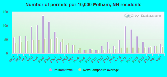
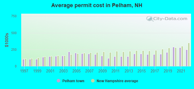
Single-family new house construction building permits:
- 2022: 37 buildings, average cost: $247,600
- 2021: 30 buildings, average cost: $279,800
- 2020: 24 buildings, average cost: $287,400
- 2019: 47 buildings, average cost: $207,300
- 2018: 68 buildings, average cost: $182,600
- 2017: 95 buildings, average cost: $178,600
- 2016: 107 buildings, average cost: $178,800
- 2015: 54 buildings, average cost: $187,700
- 2014: 30 buildings, average cost: $189,400
- 2013: 45 buildings, average cost: $147,400
- 2012: 29 buildings, average cost: $147,900
- 2011: 13 buildings, average cost: $148,800
- 2010: 17 buildings, average cost: $120,600
- 2009: 13 buildings, average cost: $155,500
- 2008: 15 buildings, average cost: $177,100
- 2007: 34 buildings, average cost: $185,500
- 2006: 34 buildings, average cost: $191,700
- 2005: 46 buildings, average cost: $202,100
- 2004: 86 buildings, average cost: $217,900
- 2003: 127 buildings, average cost: $157,400
- 2002: 150 buildings, average cost: $150,400
- 2001: 111 buildings, average cost: $147,200
- 2000: 106 buildings, average cost: $139,400
- 1999: 69 buildings, average cost: $108,700
- 1998: 70 buildings, average cost: $108,700
- 1997: 63 buildings, average cost: $108,700
| Here: | 3.3% |
| New Hampshire: | 2.5% |
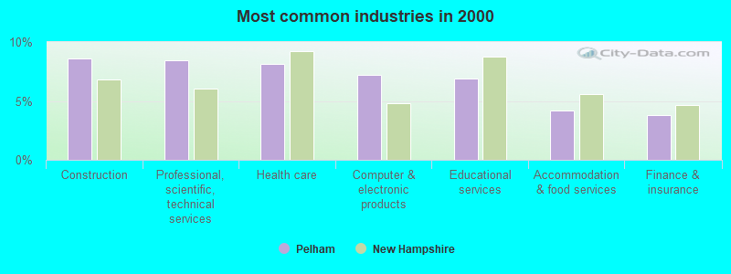
- Construction (8.6%)
- Professional, scientific, technical services (8.5%)
- Health care (8.2%)
- Computer & electronic products (7.2%)
- Educational services (6.9%)
- Accommodation & food services (4.2%)
- Finance & insurance (3.8%)
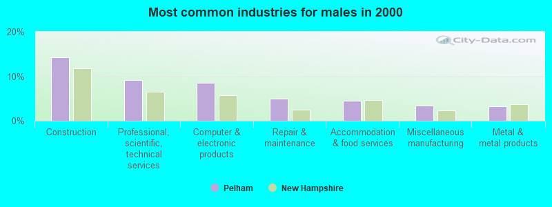
- Construction (14.2%)
- Professional, scientific, technical services (9.2%)
- Computer & electronic products (8.5%)
- Repair & maintenance (4.9%)
- Accommodation & food services (4.5%)
- Miscellaneous manufacturing (3.4%)
- Metal & metal products (3.3%)
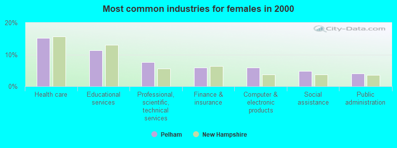
- Health care (15.1%)
- Educational services (11.3%)
- Professional, scientific, technical services (7.6%)
- Finance & insurance (5.9%)
- Computer & electronic products (5.9%)
- Social assistance (4.7%)
- Public administration (4.0%)
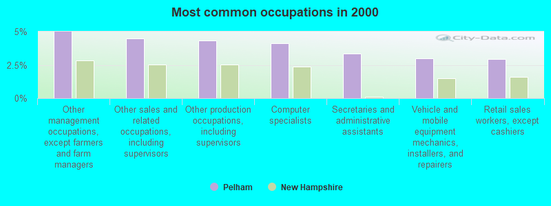
- Other management occupations, except farmers and farm managers (5.0%)
- Other sales and related occupations, including supervisors (4.5%)
- Other production occupations, including supervisors (4.3%)
- Computer specialists (4.1%)
- Secretaries and administrative assistants (3.4%)
- Vehicle and mobile equipment mechanics, installers, and repairers (3.0%)
- Retail sales workers, except cashiers (3.0%)
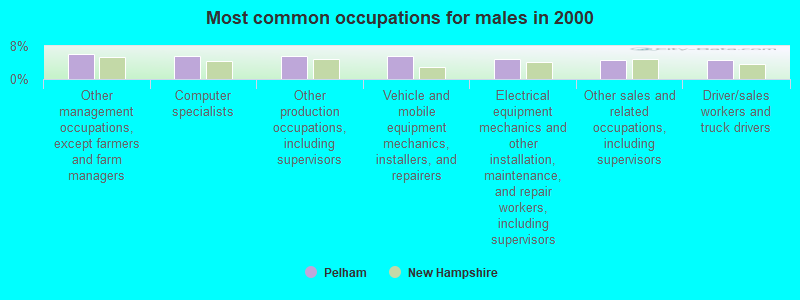
- Other management occupations, except farmers and farm managers (6.1%)
- Computer specialists (5.7%)
- Other production occupations, including supervisors (5.5%)
- Vehicle and mobile equipment mechanics, installers, and repairers (5.5%)
- Electrical equipment mechanics and other installation, maintenance, and repair workers, including supervisors (4.8%)
- Other sales and related occupations, including supervisors (4.7%)
- Driver/sales workers and truck drivers (4.6%)
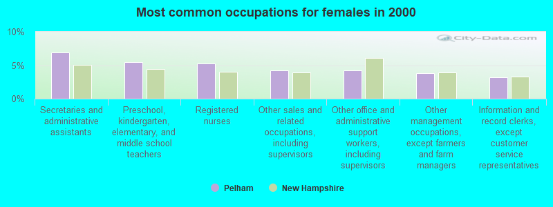
- Secretaries and administrative assistants (6.9%)
- Preschool, kindergarten, elementary, and middle school teachers (5.5%)
- Registered nurses (5.3%)
- Other sales and related occupations, including supervisors (4.3%)
- Other office and administrative support workers, including supervisors (4.3%)
- Other management occupations, except farmers and farm managers (3.8%)
- Information and record clerks, except customer service representatives (3.2%)
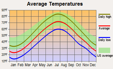
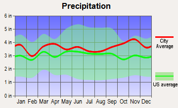
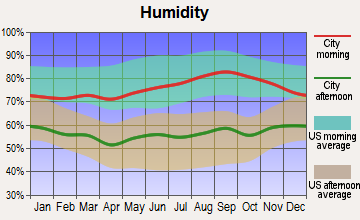
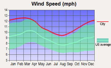
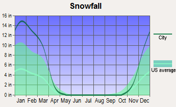
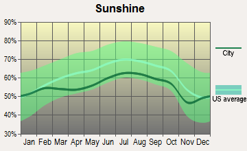
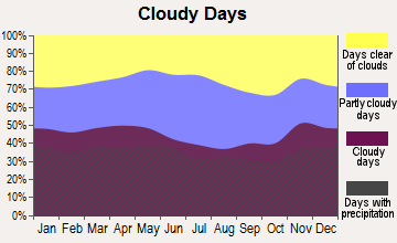
Average climate in Pelham, New Hampshire
Based on data reported by over 4,000 weather stations
(lower is better)
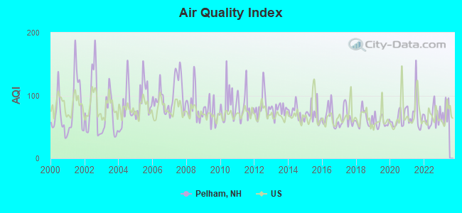
Air Quality Index (AQI) level in 2022 was 64.9. This is about average.
| City: | 64.9 |
| U.S.: | 72.6 |
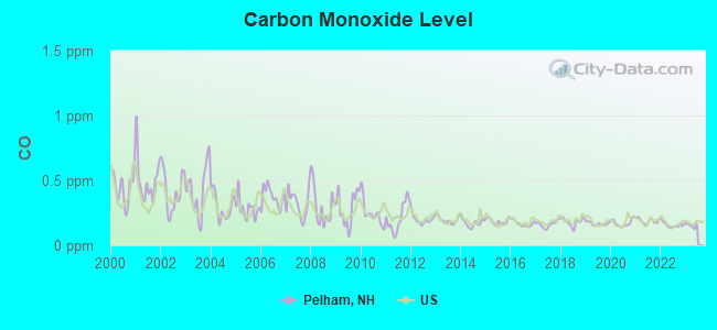
Carbon Monoxide (CO) [ppm] level in 2022 was 0.157. This is significantly better than average. Closest monitor was 6.1 miles away from the city center.
| City: | 0.157 |
| U.S.: | 0.251 |
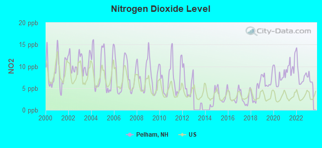
Nitrogen Dioxide (NO2) [ppb] level in 2022 was 7.96. This is significantly worse than average. Closest monitor was 6.0 miles away from the city center.
| City: | 7.96 |
| U.S.: | 5.11 |
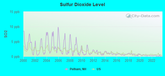
Sulfur Dioxide (SO2) [ppb] level in 2022 was 0.338. This is significantly better than average. Closest monitor was 6.0 miles away from the city center.
| City: | 0.338 |
| U.S.: | 1.515 |

Ozone [ppb] level in 2022 was 27.0. This is better than average. Closest monitor was 6.1 miles away from the city center.
| City: | 27.0 |
| U.S.: | 33.3 |
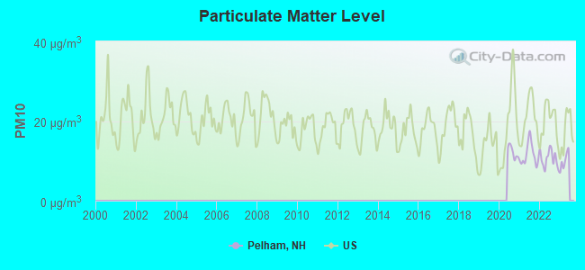
Particulate Matter (PM10) [µg/m3] level in 2022 was 10.6. This is significantly better than average. Closest monitor was 6.5 miles away from the city center.
| City: | 10.6 |
| U.S.: | 19.2 |
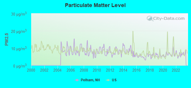
Particulate Matter (PM2.5) [µg/m3] level in 2022 was 6.19. This is better than average. Closest monitor was 6.0 miles away from the city center.
| City: | 6.19 |
| U.S.: | 8.11 |
Tornado activity:
Pelham-area historical tornado activity is above New Hampshire state average. It is 35% smaller than the overall U.S. average.
On 6/9/1953, a category F4 (max. wind speeds 207-260 mph) tornado 31.7 miles away from the Pelham town center killed 90 people and injured 1228 people and caused between $50,000,000 and $500,000,000 in damages.
On 9/29/1974, a category F3 (max. wind speeds 158-206 mph) tornado 10.1 miles away from the town center injured one person and caused between $50,000 and $500,000 in damages.
Earthquake activity:
Pelham-area historical earthquake activity is significantly above New Hampshire state average. It is 72% smaller than the overall U.S. average.On 4/20/2002 at 10:50:47, a magnitude 5.3 (5.3 ML, Depth: 3.0 mi, Class: Moderate, Intensity: VI - VII) earthquake occurred 171.0 miles away from Pelham center
On 10/7/1983 at 10:18:46, a magnitude 5.3 (5.1 MB, 5.3 LG, 5.1 ML) earthquake occurred 173.6 miles away from the city center
On 1/19/1982 at 00:14:42, a magnitude 4.7 (4.5 MB, 4.7 MD, 4.5 LG, Class: Light, Intensity: IV - V) earthquake occurred 54.8 miles away from Pelham center
On 4/20/2002 at 10:50:47, a magnitude 5.2 (5.2 MB, 4.2 MS, 5.2 MW, 5.0 MW) earthquake occurred 170.5 miles away from Pelham center
On 10/16/2012 at 23:12:25, a magnitude 4.7 (4.7 ML, Depth: 10.0 mi) earthquake occurred 68.5 miles away from Pelham center
On 8/22/1992 at 12:20:32, a magnitude 4.8 (4.8 MB, 3.8 MS, 4.7 LG, Depth: 6.2 mi) earthquake occurred 256.4 miles away from the city center
Magnitude types: regional Lg-wave magnitude (LG), body-wave magnitude (MB), duration magnitude (MD), local magnitude (ML), surface-wave magnitude (MS), moment magnitude (MW)
Natural disasters:
The number of natural disasters in Hillsborough County (27) is a lot greater than the US average (15).Major Disasters (Presidential) Declared: 17
Emergencies Declared: 10
Causes of natural disasters: Storms: 13, Floods: 11, Winter Storms: 5, Snowstorms: 4, Hurricanes: 3, Snows: 3, Blizzard: 1, Ice Storm: 1, Snowfall: 1, Wind: 1 (Note: some incidents may be assigned to more than one category).
Hospitals and medical centers near Pelham:
- HHCA - NEW ENGLAND NURSING SERVICES (Home Health Center, about 5 miles away; SALEM, NH)
- SALEM VISITING NURSE ASSOCIATION (Home Health Center, about 5 miles away; SALEM, NH)
- FAIRVIEW NURSING HOME (Nursing Home, about 6 miles away; HUDSON, NH)
- HERITAGE SKILLED NURSING AND REHABILITATION (Nursing Home, about 6 miles away; LOWELL, MA)
- CHRISTIAN HILL CONV MOME (Nursing Home, about 6 miles away; LOWELL, MA)
- LOWELL HEALTH CARE CENTER (Nursing Home, about 6 miles away; LOWELL, MA)
- LOWELL GENERAL HOSPITAL Acute Care Hospitals (about 7 miles away; LOWELL, MA)
Airports and heliports located in Pelham:
See details about Airports and heliports located in Pelham, NHColleges/universities with over 2000 students nearest to Pelham:
- University of Massachusetts-Lowell (about 6 miles; Lowell, MA; Full-time enrollment: 12,341)
- Merrimack College (about 12 miles; North Andover, MA; FT enrollment: 2,734)
- Northern Essex Community College (about 15 miles; Haverhill, MA; FT enrollment: 4,737)
- Middlesex Community College (about 15 miles; Bedford, MA; FT enrollment: 6,040)
- Mount Washington College (about 19 miles; Manchester, NH; FT enrollment: 2,187)
- Saint Anselm College (about 20 miles; Manchester, NH; FT enrollment: 2,059)
- North Shore Community College (about 21 miles; Danvers, MA; FT enrollment: 5,195)
Public high school in Pelham:
- PELHAM HIGH SCHOOL (Students: 705, Location: 85 MARSH RD., Grades: 9-12)
Public elementary/middle schools in Pelham:
- PELHAM ELEMENTARY SCHOOL (Students: 925, Location: 61 MARSH RD., Grades: PK-5)
- PELHAM MEMORIAL SCHOOL (Students: 533, Location: 59 MARSH RD., Grades: 6-8)
Private elementary/middle school in Pelham:
- ST PATRICK SCHOOL (Students: 183, Location: 16 MAIN ST, Grades: KG-8)
Points of interest:
Notable locations in Pelham: Camp Alexander (A), Pine Valley Golf Club (B), Pelham Fire Department (C), Pelham Town Hall (D), Pelham Public Library (E). Display/hide their locations on the map
Churches in Pelham include: New England Pentecostal Church (A), Londonderry Christian Church (B), Londonderry Baptist Church (C), Pelham Baptist Church (D), Korean Methodist Church (E), Saint Patrick Church (F), Saint Judes Parish Community Church (G), First Congregational Church (H). Display/hide their locations on the map
Cemeteries: Atwood Cemetery (1), Israel Brotherhood Cemetery (2), Gumpas Cemetery (3), Saint Casimirs Cemetery (4), Gibson Cemetery (5). Display/hide their locations on the map
Lakes and reservoirs: Harris Pond (A), Little Island Pond (B), Gumpas Pond (C). Display/hide their locations on the map
Streams, rivers, and creeks: Tonys Brook (A), Island Pond Brook (B), Golden Brook (C). Display/hide their locations on the map
Birthplace of: Sean Caisse - Racing driver.
Drinking water stations with addresses in Pelham and their reported violations in the past:
OLD LAWRENCE ROAD (Population served: 25, Groundwater):Past health violations:TOWN OF PELHAM MUNICIPAL CMPLX (Address: 6 VILLAGE GREEN , Population served: 25, Groundwater):Past monitoring violations:
- MCL, Monthly (TCR) - In JAN-2014, Contaminant: Coliform. Follow-up actions: St Public Notif requested (JAN-16-2014), St Violation/Reminder Notice (JAN-16-2014), St Public Notif received (FEB-18-2014)
- MCL, Acute (TCR) - In AUG-2013, Contaminant: Coliform. Follow-up actions: St Public Notif requested (AUG-19-2013), St Violation/Reminder Notice (AUG-19-2013), St Public Notif received (AUG-20-2013)
- MCL, Monthly (TCR) - In MAY-2013, Contaminant: Coliform. Follow-up actions: St Public Notif requested (MAY-30-2013), St Violation/Reminder Notice (MAY-30-2013), St Public Notif received (JUN-17-2013)
- MCL, Average - Between JUL-2012 and SEP-2012, Contaminant: Combined Uranium. Follow-up actions: St Public Notif requested (OCT-11-2012), St Violation/Reminder Notice (OCT-11-2012), St Public Notif received (NOV-30-2012), St Compliance achieved (FEB-28-2013)
- MCL, Average - Between JAN-2011 and MAR-2011, Contaminant: Combined Uranium. Follow-up actions: St Public Notif requested (MAR-22-2011), St Violation/Reminder Notice (MAR-22-2011), St Public Notif received (JUN-24-2011), St Compliance achieved (FEB-28-2013)
- MCL, Average - Between JAN-2011 and MAR-2011, Contaminant: Combined Radium (-226 and -228). Follow-up actions: St Public Notif requested (MAR-22-2011), St Violation/Reminder Notice (MAR-22-2011), St Public Notif received (JUN-24-2011), St Compliance achieved (FEB-28-2013)
- 24 other older health violations
- Monitoring, Source Water (GWR) - Between APR-03-2013 and MAY-03-2013, Contaminant: E. COLI. Follow-up actions: St Public Notif requested (APR-22-2013), St Violation/Reminder Notice (APR-22-2013), St Compliance achieved (APR-29-2013), St Public Notif received (JUN-26-2013)
- Monitoring, Repeat Major (TCR) - In MAR-2013, Contaminant: Coliform (TCR). Follow-up actions: St Public Notif requested (APR-22-2013), St Violation/Reminder Notice (APR-22-2013), St Compliance achieved (APR-30-2013), St Public Notif received (JUN-26-2013)
- Follow-up Or Routine LCR Tap M/R - In JUL-01-2012, Contaminant: Lead and Copper Rule. Follow-up actions: St Public Notif requested (FEB-08-2013), St Violation/Reminder Notice (FEB-08-2013), St Compliance achieved (FEB-08-2013), St Public Notif received (MAR-07-2013)
- Monitoring, Source Water (GWR) - Between JAN-01-2011 and FEB-01-2011, Contaminant: E. COLI. Follow-up actions: St Public Notif requested (JAN-21-2011), St Violation/Reminder Notice (JAN-21-2011), St Compliance achieved (JAN-21-2011), St Public Notif received (FEB-17-2011)
- Monitoring, Repeat Major (TCR) - In DEC-2010, Contaminant: Coliform (TCR). Follow-up actions: St Public Notif requested (JAN-21-2011), St Violation/Reminder Notice (JAN-21-2011), St Compliance achieved (JAN-21-2011), St Public Notif received (FEB-04-2011)
Past monitoring violations:
- 4 routine major monitoring violations
Drinking water stations with addresses in Pelham that have no violations reported:
- SAINT PATRICKS CHURCH (Population served: 75, Primary Water Source Type: Groundwater)
| This town: | 3.0 people |
| New Hampshire: | 2.5 people |
| This town: | 81.2% |
| Whole state: | 66.3% |
| This town: | 5.9% |
| Whole state: | 8.3% |
Likely homosexual households (counted as self-reported same-sex unmarried-partner households)
- Lesbian couples: 0.3% of all households
- Gay men: 0.3% of all households
| This town: | 3.0% |
| Whole state: | 6.5% |
| This town: | 1.6% |
| Whole state: | 2.8% |
Banks with branches in Pelham (2011 data):
- Enterprise Bank and Trust Company: Pelham Branch at 139 Bridge Street, branch established on 2012/02/09. Info updated 2006/11/03: Bank assets: $1,488.4 mil, Deposits: $1,333.6 mil, headquarters in Lowell, MA, positive income, Commercial Lending Specialization, 20 total offices, Holding Company: Enterprise Bancorp, Inc.
- RBS Citizens, National Association: Pelham Branch at Route 38 And Old Bridge Street, branch established on 1983/02/01. Info updated 2007/09/19: Bank assets: $106,940.6 mil, Deposits: $75,690.2 mil, headquarters in Providence, RI, positive income, 1135 total offices, Holding Company: Uk Financial Investments Limited
- Sovereign Bank, National Association: Route 38 Branch at 150 Bridge Street, branch established on 1968/12/12. Info updated 2012/01/31: Bank assets: $78,146.9 mil, Deposits: $48,042.9 mil, headquarters in Wilmington, DE, positive income, Commercial Lending Specialization, 718 total offices, Holding Company: Banco Santander, S.A.
For population 15 years and over in Pelham:
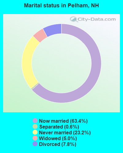
- Never married: 23.2%
- Now married: 63.4%
- Separated: 0.6%
- Widowed: 5.0%
- Divorced: 7.8%
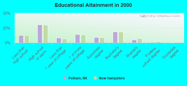
For population 25 years and over in Pelham:
- High school or higher: 87.2%
- Bachelor's degree or higher: 24.7%
- Graduate or professional degree: 6.5%
- Unemployed: 3.9%
- Mean travel time to work (commute): 27.2 minutes
| Here: | 9.7 |
| New Hampshire average: | 10.9 |


Graphs represent county-level data. Detailed 2008 Election Results
Religion statistics for Pelham, NH (based on Hillsborough County data)


| Religion | Adherents | Congregations |
|---|---|---|
| Catholic | 124,993 | 40 |
| Evangelical Protestant | 20,588 | 103 |
| Mainline Protestant | 17,794 | 60 |
| Other | 7,365 | 35 |
| Orthodox | 2,990 | 7 |
| Black Protestant | - | 1 |
| None | 226,991 | - |
Food Environment Statistics:
| This county: | 1.82 / 10,000 pop. |
| New Hampshire: | 2.14 / 10,000 pop. |
| Here: | 0.12 / 10,000 pop. |
| New Hampshire: | 0.15 / 10,000 pop. |
| Here: | 1.65 / 10,000 pop. |
| State: | 1.78 / 10,000 pop. |
| This county: | 2.67 / 10,000 pop. |
| New Hampshire: | 4.02 / 10,000 pop. |
| This county: | 8.23 / 10,000 pop. |
| New Hampshire: | 9.70 / 10,000 pop. |
| Here: | 6.9% |
| State: | 7.6% |
| Here: | 24.5% |
| New Hampshire: | 24.4% |
| Hillsborough County: | 15.1% |
| New Hampshire: | 15.9% |
6.73% of this county's 2021 resident taxpayers lived in other counties in 2020 ($92,767 average adjusted gross income)
| Here: | 6.73% |
| New Hampshire average: | 7.66% |
0.01% of residents moved from foreign countries ($183 average AGI)
Hillsborough County: 0.01% New Hampshire average: 0.01%
Top counties from which taxpayers relocated into this county between 2020 and 2021:
| from Middlesex County, MA | |
| from Rockingham County, NH | |
| from Merrimack County, NH |
6.49% of this county's 2020 resident taxpayers moved to other counties in 2021 ($81,100 average adjusted gross income)
| Here: | 6.49% |
| New Hampshire average: | 6.80% |
0.02% of residents moved to foreign countries ($105 average AGI)
Hillsborough County: 0.02% New Hampshire average: 0.01%
Top counties to which taxpayers relocated from this county between 2020 and 2021:
| to Rockingham County, NH | |
| to Merrimack County, NH | |
| to Middlesex County, MA |
| Businesses in Pelham, NH | ||||
| Name | Count | Name | Count | |
|---|---|---|---|---|
| Curves | 1 | Quiznos | 1 | |
| Decora Cabinetry | 2 | RadioShack | 1 | |
| Dunkin Donuts | 2 | Rite Aid | 1 | |
| FedEx | 1 | T-Mobile | 1 | |
| GNC | 1 | True Value | 1 | |
| MasterBrand Cabinets | 4 | UPS | 1 | |
| McDonald's | 1 | Walgreens | 1 | |
Strongest AM radio stations in Pelham:
- WCEC (1110 AM; daytime; 5 kW; SALEM, NH; Owner: COSTA-EAGLE RADIO VENTURES LTD PARTNERSHIP)
- WRKO (680 AM; 50 kW; BOSTON, MA; Owner: ENTERCOM BOSTON LICENSE, LLC)
- WCAP (980 AM; 5 kW; LOWELL, MA; Owner: NORTHEAST RADIO, INC.)
- WDER (1320 AM; 10 kW; DERRY, NH; Owner: BLOUNT COMMUNICATIONS, INC. OF NH)
- WEEI (850 AM; 50 kW; BOSTON, MA; Owner: ENTERCOM BOSTON LICENSE, LLC)
- WWZN (1510 AM; 50 kW; BOSTON, MA; Owner: ROSE CITY RADIO CORPORATION)
- WKOX (1200 AM; 50 kW; FRAMINGHAM, MA; Owner: CAPSTAR TX LIMITED PARTNERSHIP)
- WSMN (1590 AM; 5 kW; NASHUA, NH; Owner: 1590 BROADCASTING CORP.)
- WBIX (1060 AM; 40 kW; NATICK, MA; Owner: LANGER BROADCASTING CORPORATION)
- WBZ (1030 AM; 50 kW; BOSTON, MA; Owner: INFINITY BROADCASTING OPERATIONS, INC.)
- WCRN (830 AM; 50 kW; WORCESTER, MA; Owner: CARTER BROADCASTING CORPORATION)
- WRCA (1330 AM; 25 kW; WALTHAM, MA; Owner: WRCA LICENSE, LLC)
- WLLH (1400 AM; 1 kW; LOWELL, MA; Owner: MEGA COMMUNICATIONS OF LOWELL LICENSEE, LLC)
Strongest FM radio stations in Pelham:
- WHOB (106.3 FM; NASHUA, NH; Owner: TELE-MEDIA COMPANY OF NEW HAMPSHIRE, L.L.C.)
- WKLB-FM (99.5 FM; LOWELL, MA; Owner: GREATER BOSTON RADIO, INC.)
- W227AM (93.3 FM; ANDOVER, MA; Owner: GREATER BOSTON RADIO, INC.)
- WXRV (92.5 FM; HAVERHILL, MA; Owner: BEANPOT BROADCASTING CORP.)
- WJUL (91.5 FM; LOWELL, MA; Owner: UNIVERSITY OF MASSACHUSETTS, LOWELL)
- WGIR-FM (101.1 FM; MANCHESTER, NH; Owner: CAPSTAR TX LIMITED PARTNERSHIP)
- WQLL (96.5 FM; BEDFORD, NH; Owner: SAGA COMMUNICATIONS OF NEW ENGLAND, LLC)
- WLMW (90.7 FM; MANCHESTER, NH; Owner: KNOWLEDGE FOR LIFE)
- WFEX (92.1 FM; PETERBOROUGH, NH; Owner: FNX BROADCASTING OF NEW HAMPSHIRE LLC)
- WZID (95.7 FM; MANCHESTER, NH; Owner: SAGA COMMUNICATIONS OF NEW ENGLAND, LLC)
- WXKS-FM (107.9 FM; MEDFORD, MA; Owner: AMFM RADIO LICENSES, L.L.C.)
- WBMX (98.5 FM; BOSTON, MA; Owner: INFINITY RADIO OPERATIONS INC.)
- WMJX (106.7 FM; BOSTON, MA; Owner: GREATER BOSTON RADIO, INC.)
- WJMN (94.5 FM; BOSTON, MA; Owner: AMFM RADIO LICENSES, L.L.C.)
- WCRB (102.5 FM; WALTHAM, MA; Owner: CHARLES RIVER BROADCASTING WCRB LICE)
- WTKK (96.9 FM; BOSTON, MA; Owner: GREATER BOSTON RADIO, INC.)
- WROR-FM (105.7 FM; FRAMINGHAM, MA; Owner: GREATER BOSTON RADIO, INC.)
- WBOS (92.9 FM; BROOKLINE, MA; Owner: GREATER BOSTON RADIO, INC.)
- WGBH (89.7 FM; BOSTON, MA; Owner: WGBH EDUCATIONAL FOUNDATION)
- WBUR-FM (90.9 FM; BOSTON, MA; Owner: TRUSTEES OF BOSTON UNIVERSITY)
TV broadcast stations around Pelham:
- WNDS (Channel 50; DERRY, NH; Owner: CTV OF DERRY, INC)
- WFXZ-CA (Channel 24; BOSTON, MA; Owner: BOSTON BROADCASTING CORP.)
- WCVB-TV (Channel 5; BOSTON, MA; Owner: WCVB HEARST-ARGYLE TV, INC.)
- WGBH-TV (Channel 2; BOSTON, MA; Owner: WGBH EDUCATIONAL FOUNDATION)
- WUTF (Channel 66; MARLBOROUGH, MA; Owner: TELEFUTURA BOSTON LLC)
- WHDH-TV (Channel 7; BOSTON, MA; Owner: WHDH-TV)
- WMFP (Channel 62; LAWRENCE, MA; Owner: WSAH LICENSE, INC.)
- WBZ-TV (Channel 4; BOSTON, MA; Owner: VIACOM INC.)
- WGBX-TV (Channel 44; BOSTON, MA; Owner: WGBH EDUCATIONAL FOUNDATION)
- WSBK-TV (Channel 38; BOSTON, MA; Owner: VIACOM INC.)
- WLVI-TV (Channel 56; CAMBRIDGE, MA; Owner: WLVI, INC.)
- WFXT (Channel 25; BOSTON, MA; Owner: FOX TELEVISION STATIONS INC.)
- WUNI (Channel 27; WORCESTER, MA; Owner: ENTRAVISION HOLDINGS, LLC)
- WBPX (Channel 68; BOSTON, MA; Owner: PAXSON BOSTON-68 LICENSE, INC.)
- WHDN-LP (Channel 26; BOSTON, MA; Owner: GUENTER MARKSTEINER)
- W40BO (Channel 40; BOSTON, MA; Owner: PAXSON COMMUNICATIONS LPTV, INC.)
- WTMU-LP (Channel 32; BOSTON, MA; Owner: ZGS BOSTON, INC.)
- WYCN-LP (Channel 13; NASHUA, NH; Owner: CENTER BROADCASTING CORP. OF NEW HAMPSHIRE)
- WCEA-LP (Channel 58; BOSTON, MA; Owner: CHANNEL 19 TV CORPORATION)
- W33AK (Channel 33; NASHUA, NH; Owner: CENTER B/CING CORPORATION OF NEW HAMPSHIRE)
- WMEA-TV (Channel 26; BIDDEFORD, ME; Owner: MAINE PUBLIC BROADCASTING CORP.)
- W29AT (Channel 29; MANCHESTER, NH; Owner: CENTER BROADCASTING CORP. OF NEW HAMPSHIRE)
- National Bridge Inventory (NBI) Statistics
- 7Number of bridges
- 39ft / 11.7mTotal length
- $21,994,000Total costs
- 28,394Total average daily traffic
- 1,966Total average daily truck traffic
- 42,020Total future (year 2042) average daily traffic
FCC Registered Cell Phone Towers:
1 (See the full list of FCC Registered Cell Phone Towers in Pelham)FCC Registered Antenna Towers:
29 (See the full list of FCC Registered Antenna Towers)FCC Registered Broadcast Land Mobile Towers:
13 (See the full list of FCC Registered Broadcast Land Mobile Towers in Pelham, NH)FCC Registered Microwave Towers:
2- BOS0602, 60 Pulpit Rock Road Nas212a (Lat: 42.701417 Lon: -71.316417), Type: Pole, Structure height: 45.7 m, Call Sign: WQBP584, Licensee ID: L01728370,
Assigned Frequencies: 10875.0 MHz, Grant Date: 11/18/2004, Expiration Date: 11/18/2014, Cancellation Date: 09/10/2013, Certifier: Joseph M Sandri Jr., Registrant: Fibertower Network Services, Corp., Debtor-In-Possession, 1875 Eye Street, Nw, 5th Floor, Room 505, Washington, DC 20006, Phone: (202) 223-1028, Email:
- NO PELHAM, 1.2 Miles Ssw Of North (Lat: 42.759250 Lon: -71.365611), Overall height: 49.7 m, Call Sign: WDU427, Licensee ID: L00020590,
Assigned Frequencies: 6197.24 MHz, 6226.89 MHz, 10755.0 MHz, 10715.0 MHz, 6256.54 MHz, 6286.19 MHz, 10835.0 MHz, 10875.0 MHz, 6315.84 MHz, 6345.49 MHz... (+12 more), Grant Date: 02/15/2000, Expiration Date: 02/01/2010, Cancellation Date: 06/20/2000, Registrant: At&t Communications Of New England Inc, 1200 Peachtree St Loc 15w24, Atlanta, GA 30309
FCC Registered Maritime Coast & Aviation Ground Towers:
1- 50 Bush Hill Road (Lat: 42.737250 Lon: -71.354000), Type: Bant, Structure height: 2 m, Overall height: 3 m, Call Sign: WQRI879,
Assigned Frequencies: 123.475 MHz, Grant Date: 03/26/2018, Expiration Date: 05/23/2023, Cancellation Date: 07/29/2023, Certifier: Karen I Dyberg, Registrant: Raytheon Ids, 1001 Boston Post Road, Ms 3-1-3355, Marlborough, MA 01752, Phone: (508) 490-2723, Email:
FCC Registered Amateur Radio Licenses:
77 (See the full list of FCC Registered Amateur Radio Licenses in Pelham)FAA Registered Aircraft:
19 (See the full list of FAA Registered Aircraft in Pelham)2003 - 2018 National Fire Incident Reporting System (NFIRS) incidents
- Fire incident types reported to NFIRS in Pelham, NH
- 30453.6%Structure Fires
- 17230.3%Outside Fires
- 6210.9%Mobile Property/Vehicle Fires
- 295.1%Other
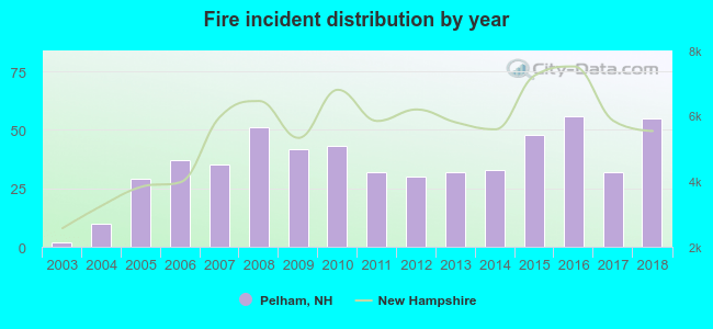 According to the data from the years 2003 - 2018 the average number of fire incidents per year is 35. The highest number of reported fires - 56 took place in 2016, and the least - 2 in 2003. The data has a rising trend.
 When looking into fire subcategories, the most reports belonged to: Structure Fires (53.6%), and Outside Fires (30.3%).
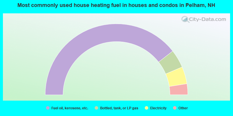
- 78.9%Fuel oil, kerosene, etc.
- 8.3%Bottled, tank, or LP gas
- 7.8%Electricity
- 3.1%Wood
- 1.3%Coal or coke
- 0.4%Utility gas
- 0.2%Other fuel
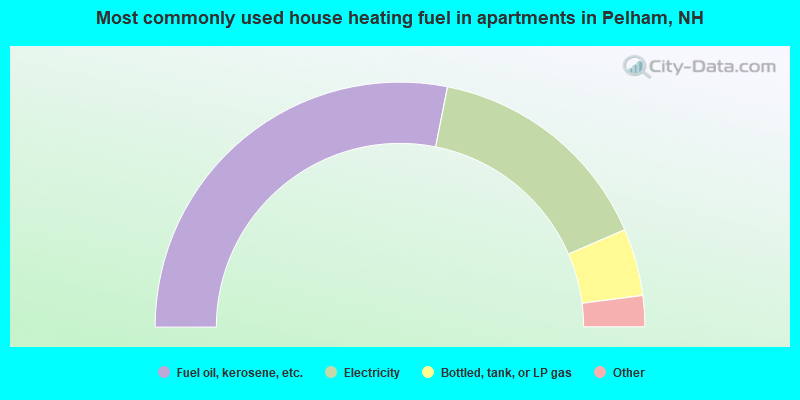
- 56.3%Fuel oil, kerosene, etc.
- 30.8%Electricity
- 8.9%Bottled, tank, or LP gas
- 1.7%Wood
- 1.4%Utility gas
- 1.0%Other fuel
Pelham compared to New Hampshire state average:
- Unemployed percentage significantly below state average.
- Black race population percentage below state average.
- Hispanic race population percentage below state average.
- Foreign-born population percentage below state average.
- Renting percentage significantly below state average.
- Length of stay since moving in significantly above state average.
- Number of rooms per house significantly below state average.
- House age significantly below state average.
Pelham on our top lists:
- #11 on the list of "Top 101 cities with largest percentage of females in occupations: air transportation workers (population 5,000+)"
- #13 on the list of "Top 101 cities with largest percentage of males in industries: furniture and home furnishing merchant wholesalers (population 5,000+)"
- #16 on the list of "Top 101 cities with largest percentage of females in occupations: drafters, engineering, and mapping technicians (population 5,000+)"
- #16 on the list of "Top 101 cities with largest percentage of females in industries: lumber and other construction materials merchant wholesalers (population 5,000+)"
- #22 on the list of "Top 101 cities with largest percentage of males in industries: retail florists (population 5,000+)"
- #31 on the list of "Top 101 cities with largest percentage of males in occupations: printing workers (population 5,000+)"
- #36 on the list of "Top 101 cities with largest percentage of females in occupations: fishing and hunting, and forest and logging workers (population 5,000+)"
- #36 on the list of "Top 101 cities with largest percentage of females in industries: computer and electronic products (population 5,000+)"
- #36 on the list of "Top 101 cities with largest percentage of females in industries: other transportation, and support activities, and couriers (population 5,000+)"
- #36 on the list of "Top 101 cities with largest percentage of females in industries: retail florists (population 5,000+)"
- #41 on the list of "Top 101 cities with largest percentage of males in occupations: customer service representatives (population 5,000+)"
- #43 on the list of "Top 101 cities with largest percentage of females in industries: leather and allied products (population 5,000+)"
- #52 on the list of "Top 101 cities with largest percentage of males in occupations: drafters, engineering, and mapping technicians (population 5,000+)"
- #53 on the list of "Top 101 cities with largest percentage of males in industries: computer and electronic products (population 5,000+)"
- #80 on the list of "Top 101 cities with largest percentage of males in industries: miscellaneous manufacturing (population 5,000+)"
- #85 on the list of "Top 101 cities with largest percentage of males in industries: printing and related support activities (population 5,000+)"
- #100 on the list of "Top 101 cities with largest percentage of females in industries: textile mills and textile products (population 5,000+)"
- #56 (03076) on the list of "Top 101 zip codes with the largest percentage of French Canadian first ancestries (pop 5,000+)"
- #6 on the list of "Top 101 counties with the lowest Particulate Matter (PM10) Annual air pollution readings in 2012 (µg/m3)"
- #12 on the list of "Top 101 counties with the lowest Particulate Matter (PM2.5) Annual air pollution readings in 2012 (µg/m3)"
- #15 on the list of "Top 101 counties with the lowest number of infant deaths per 1000 residents 2007-2013 (pop. 50,000+)"
- #24 on the list of "Top 101 counties with the largest decrease in the number of infant deaths per 1000 residents 2000-2006 to 2007-2013 (pop. 50,000+)"
- #44 on the list of "Top 101 counties with the lowest Nitrogen Dioxide air pollution readings in 2012 (ppm)"

|
|
Total of 362 patent applications in 2008-2024.