Yuba Rural, California
Submit your own pictures of this place and show them to the world
- OSM Map
- General Map
- Google Map
- MSN Map

| Males: 1,484 | |
| Females: 1,364 |
| Median resident age: | 36.4 years |
| California median age: | 33.3 years |
Zip code: 95993
| Yuba Rural: | $71,197 |
| CA: | $91,551 |
Estimated per capita income in 2022: $38,047 (it was $20,209 in 2000)
Yuba Rural CCD income, earnings, and wages data
Estimated median house or condo value in 2022: $599,983 (it was $166,100 in 2000)
| Yuba Rural: | $599,983 |
| CA: | $715,900 |
Mean prices in 2022: all housing units: $477,964; detached houses: $500,791; townhouses or other attached units: $492,332; in 2-unit structures: over $1,000,000; in 3-to-4-unit structures: $172,512; in 5-or-more-unit structures: $165,844; mobile homes: $158,826; occupied boats, rvs, vans, etc.: $69,481
Detailed information about poverty and poor residents in Yuba Rural, CA
Compare current foreclosures near Yuba Rural, CA:
| Photo | Address | Area | Beds / Baths | Price | Details |
|---|---|---|---|---|---|

|
#1
Malkit Ct
Yuba City, CA 95993
|
2,623 sq. feet
|
3 baths 4 beds |
show details | |

|
#2
Norby Ct
Olivehurst, CA 95961
|
3,210 sq. feet
|
3 baths 5 beds |
show details | |

|
#3
Peach Tree Ln
Yuba City, CA 95993
|
1,518 sq. feet
|
2 baths 3 beds |
show details | |

|
#4
Stafford Way
Yuba City, CA 95991
|
1,052 sq. feet
|
1 baths 3 beds |
show details | |

|
#5
K St
Live Oak, CA 95953
|
888 sq. feet
|
1 baths 3 beds |
show details | |

|
#6
Bandy Way
Yuba City, CA 95991
|
752 sq. feet
|
1 baths 2 beds |
show details | |

|
#7
Butte Ave
Sutter, CA 95982
|
- sq. feet
|
2 baths 3 beds |
show details | |

|
#8
Bridge St
Meridian, CA 95957
|
864 sq. feet
|
1 baths 2 beds |
show details | |

|
#9
Bird St
Yuba City, CA 95991
|
1,359 sq. feet
|
2 baths 2 beds |
show details | |

|
#10
Alicia Ave
Olivehurst, CA 95961
|
1,052 sq. feet
|
1 baths 2 beds |
show details |
| Photo | Address | Area | Beds / Baths | Price | Details |
|---|---|---|---|---|---|

|
#11
Willowbrook Dr
Yuba City, CA 95993
|
3,142 sq. feet
|
3 baths 6 beds |
show details | |

|
#12
Norby Ct
Olivehurst, CA 95961
|
3,210 sq. feet
|
3 baths 5 beds |
show details | |

|
#13
2nd Ave
Olivehurst, CA 95961
|
704 sq. feet
|
1 baths 2 beds |
show details | |

|
#14
Main St
Yuba City, CA 95991
|
1,308 sq. feet
|
2 baths 3 beds |
show details | |

|
#15
Vista Dr
Olivehurst, CA 95961
|
1,825 sq. feet
|
2 baths 4 beds |
show details | |

|
#16
E 22nd St
Marysville, CA 95901
|
1,176 sq. feet
|
2 baths 3 beds |
show details | |

|
#17
Kyri Ct
Olivehurst, CA 95961
|
1,635 sq. feet
|
2 baths 3 beds |
show details | |

|
#18
Rose Ave
Wheatland, CA 95692
|
2,165 sq. feet
|
3 baths 4 beds |
show details | |

|
#19
Almond St
Yuba City, CA 95991
|
1,375 sq. feet
|
1 baths 2 beds |
show details | |

|
#20
Colusa Hwy
Yuba City, CA 95993
|
2,586 sq. feet
|
2 baths 4 beds |
show details |
| Photo | Address | Area | Beds / Baths | Price | Details |
|---|---|---|---|---|---|

|
#21
Erle Rd
Marysville, CA 95901
|
1,224 sq. feet
|
1 baths 3 beds |
show details | |

|
#22
Rodeo Way
Olivehurst, CA 95961
|
1,319 sq. feet
|
2 baths 3 beds |
show details | |

|
#23
Carpenter Way
Wheatland, CA 95692
|
1,878 sq. feet
|
2 baths 4 beds |
show details | |

|
#24
Bogue Rd
Yuba City, CA 95991
|
1,750 sq. feet
|
2 baths 4 beds |
show details | |

|
#25
Florain Dr
Yuba City, CA 95993
|
2,461 sq. feet
|
3 baths 3 beds |
show details | |

|
#26
Grant Way
Yuba City, CA 95991
|
1,433 sq. feet
|
2 baths 3 beds |
show details | |

|
#27
River Bank Dr
Marysville, CA 95901
|
1,513 sq. feet
|
2 baths 2 beds |
show details | |

|
#28
Freeman St
Marysville, CA 95901
|
1,152 sq. feet
|
1 baths 3 beds |
show details | |

|
#29
Heritage Way
Yuba City, CA 95991
|
2,048 sq. feet
|
3 baths 4 beds |
show details | |

|
#30
Larry Way
Yuba City, CA 95991
|
2,222 sq. feet
|
3 baths 5 beds |
show details |
| Photo | Address | Area | Beds / Baths | Price | Details |
|---|---|---|---|---|---|

|
#31
Sanborn Rd
Yuba City, CA 95993
|
3,250 sq. feet
|
3 baths 3 beds |
show details | |

|
#32
Winslow Dr
Yuba City, CA 95991
|
1,640 sq. feet
|
2 baths 3 beds |
show details | |

|
#33
Stone Wood Loop
Marysville, CA 95901
|
2,059 sq. feet
|
3 baths 4 beds |
show details | |

|
#34
Josephene Way
Yuba City, CA 95993
|
2,004 sq. feet
|
2 baths 4 beds |
show details | |

|
#35
E Lake Ct
Marysville, CA 95901
|
1,265 sq. feet
|
2 baths 3 beds |
show details | |

|
#36
Diamond Pointe Way
Yuba City, CA 95991
|
2,951 sq. feet
|
3 baths 4 beds |
show details | |

|
#37
Sebina Ct
Live Oak, CA 95953
|
1,264 sq. feet
|
2 baths 3 beds |
show details | |

|
#38
E 22nd St
Marysville, CA 95901
|
1,176 sq. feet
|
2 baths 3 beds |
show details | |

|
#39
Twain Dr
Olivehurst, CA 95961
|
1,014 sq. feet
|
2 baths 3 beds |
show details | |

|
#40
Waterhole Loop
Marysville, CA 95901
|
1,633 sq. feet
|
2 baths 3 beds |
show details |
| Photo | Address | Area | Beds / Baths | Price | Details |
|---|---|---|---|---|---|

|
#41
Cheim Blvd # 15
Marysville, CA 95901
|
1,206 sq. feet
|
2 baths 3 beds |
show details | |

|
#42
Boardwalk Dr
Marysville, CA 95901
|
2,276 sq. feet
|
2 baths 5 beds |
show details | |

|
#43
Hobart Dr
Marysville, CA 95901
|
1,487 sq. feet
|
2 baths 3 beds |
show details | |

|
#44
Kensington Dr
Olivehurst, CA 95961
|
1,755 sq. feet
|
2 baths 3 beds |
show details | |

|
#45
Arboga Rd
Olivehurst, CA 95961
|
1,248 sq. feet
|
2 baths 2 beds |
show details | |

|
#46
Rancho Rd
Marysville, CA 95901
|
784 sq. feet
|
1 baths 2 beds |
show details | |

|
#47
Tadpole Way
Marysville, CA 95901
|
1,859 sq. feet
|
2 baths 3 beds |
show details | |

|
#48
Edwards St
Marysville, CA 95901
|
1,300 sq. feet
|
2 baths 3 beds |
show details | |

|
#49
Ravine Ct
Marysville, CA 95901
|
1,870 sq. feet
|
2 baths 3 beds |
show details | |

|
Check over 1 million property listings on Foreclosure.com!
|
browse all offers | |||

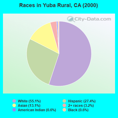
- 1,35755.1%White alone
- 67527.4%Hispanic
- 32213.1%Asian alone
- 793.2%Two or more races
- 140.6%Black alone
- 160.6%American Indian alone
- 10.04%Other race alone
 Recent articles from our blog. Our writers, many of them Ph.D. graduates or candidates, create easy-to-read articles on a wide variety of topics.
Current Local Time: PST time zone
Land area: 83.3 square miles.
Population density: 34 people per square mile (very low).

| Yuba Rural CCD: | 0.7% ($1,166) |
| California: | 0.8% ($1,564) |
Nearest city with pop. 50,000+: Roseville, CA  (29.0 miles , pop. 79,921).
Nearest city with pop. 200,000+: Sacramento, CA (35.4 miles , pop. 407,018).
Nearest city with pop. 1,000,000+: Los Angeles, CA (388.6 miles , pop. 3,694,820).
Nearest cities:
), ), ), ), Latitude: 39.04 N, Longitude: 121.68 W
Area code commonly used in this area: 530

| Here: | 8.7% |
| California: | 5.1% |
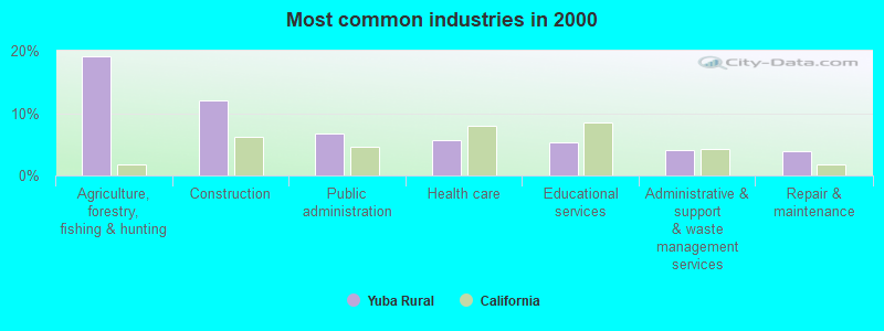
- Agriculture, forestry, fishing & hunting (19.2%)
- Construction (12.1%)
- Public administration (6.8%)
- Health care (5.7%)
- Educational services (5.3%)
- Administrative & support & waste management services (4.1%)
- Repair & maintenance (4.0%)
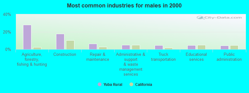
- Agriculture, forestry, fishing & hunting (28.1%)
- Construction (17.7%)
- Repair & maintenance (6.3%)
- Administrative & support & waste management services (5.0%)
- Truck transportation (4.7%)
- Educational services (4.7%)
- Public administration (4.2%)
- Public administration (11.1%)
- Health care (10.3%)
- Educational services (6.2%)
- Food (5.7%)
- Finance & insurance (5.7%)
- Professional, scientific, technical services (5.1%)
- Agriculture, forestry, fishing & hunting (4.3%)
- Agricultural workers, including supervisors (11.6%)
- Farmers and farm managers (7.6%)
- Building and grounds cleaning and maintenance occupations (6.6%)
- Other production occupations, including supervisors (5.4%)
- Vehicle and mobile equipment mechanics, installers, and repairers (5.1%)
- Driver/sales workers and truck drivers (5.0%)
- Bookkeeping, accounting, and auditing clerks (4.0%)
- Agricultural workers, including supervisors (16.4%)
- Farmers and farm managers (12.2%)
- Building and grounds cleaning and maintenance occupations (9.1%)
- Vehicle and mobile equipment mechanics, installers, and repairers (8.1%)
- Driver/sales workers and truck drivers (6.2%)
- Supervisors, construction and extraction workers (4.2%)
- Accountants and auditors (3.6%)
- Other production occupations, including supervisors (9.2%)
- Bookkeeping, accounting, and auditing clerks (8.4%)
- Legal support workers (5.4%)
- Secretaries and administrative assistants (5.1%)
- Other protective service workers, including supervisors (4.3%)
- Material recording, scheduling, dispatching, and distributing workers (3.8%)
- Health technologists and technicians (3.8%)
Average climate in Yuba Rural, California
Based on data reported by over 4,000 weather stations


(lower is better)
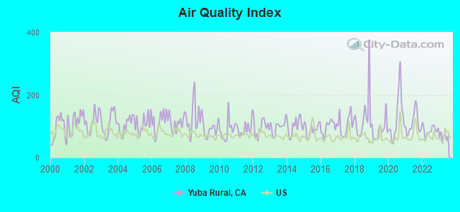
Air Quality Index (AQI) level in 2023 was 66.2. This is about average.
| City: | 66.2 |
| U.S.: | 72.6 |
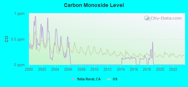
Carbon Monoxide (CO) [ppm] level in 2018 was 0.191. This is better than average. Closest monitor was 7.4 miles away from the city center.
| City: | 0.191 |
| U.S.: | 0.251 |
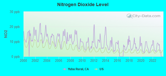
Nitrogen Dioxide (NO2) [ppb] level in 2022 was 6.65. This is worse than average. Closest monitor was 7.4 miles away from the city center.
| City: | 6.65 |
| U.S.: | 5.11 |
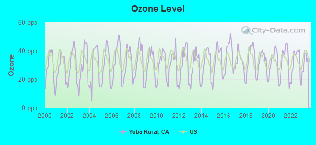
Ozone [ppb] level in 2023 was 32.5. This is about average. Closest monitor was 7.0 miles away from the city center.
| City: | 32.5 |
| U.S.: | 33.3 |
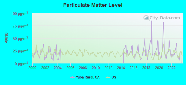
Particulate Matter (PM10) [µg/m3] level in 2022 was 21.3. This is about average. Closest monitor was 7.0 miles away from the city center.
| City: | 21.3 |
| U.S.: | 19.2 |
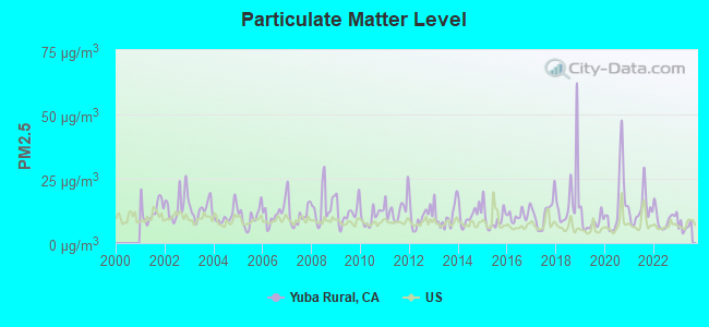
Particulate Matter (PM2.5) [µg/m3] level in 2023 was 6.40. This is better than average. Closest monitor was 7.6 miles away from the city center.
| City: | 6.40 |
| U.S.: | 8.11 |
Earthquake activity:
Yuba Rural-area historical earthquake activity is significantly above California state average. It is 7342% greater than the overall U.S. average.On 4/18/1906 at 13:12:21, a magnitude 7.9 (7.9 UK, Class: Major, Intensity: VIII - XII) earthquake occurred 101.3 miles away from Yuba Rural center, causing $524,000,000 total damage
On 1/31/1922 at 13:17:28, a magnitude 7.6 (7.6 UK) earthquake occurred 235.4 miles away from Yuba Rural center
On 10/3/1915 at 06:52:48, a magnitude 7.6 (7.6 UK) earthquake occurred 244.1 miles away from the city center
On 4/25/1992 at 18:06:04, a magnitude 7.2 (6.3 MB, 7.1 MS, 7.2 MW, 7.1 MW, Depth: 9.4 mi) earthquake occurred 156.0 miles away from Yuba Rural center, causing $75,000,000 total damage
On 10/18/1989 at 00:04:15, a magnitude 7.1 (6.5 MB, 7.1 MS, 6.9 MW, 7.0 ML) earthquake occurred 133.6 miles away from Yuba Rural center, causing 62 deaths (62 shaking deaths) and 3757 injuries, causing $1,305,032,704 total damage
On 12/21/1932 at 06:10:09, a magnitude 7.2 (7.2 UK) earthquake occurred 197.4 miles away from Yuba Rural center
Magnitude types: body-wave magnitude (MB), local magnitude (ML), surface-wave magnitude (MS), moment magnitude (MW)
Natural disasters:
The number of natural disasters in Sutter County (15) is near the US average (15).Major Disasters (Presidential) Declared: 10
Emergencies Declared: 2
Causes of natural disasters: Floods: 11, Storms: 5, Winter Storms: 5, Landslides: 3, Mudslides: 3, Drought: 1, Freeze: 1, Heavy Rain: 1, Hurricane: 1, Tornado: 1, Other: 1 (Note: some incidents may be assigned to more than one category).
Hospitals and medical centers near Yuba Rural:
- SUTTER NORTH HOME HEALTH (Home Health Center, about 8 miles away; YUBA CITY, CA)
- SUTTER SURGICAL HOSPITAL - NORTH VALLEY Acute Care Hospitals (about 8 miles away; YUBA CITY, CA)
- SIERRA VISTA ICF/DD (Hospital, about 8 miles away; YUBA CITY, CA)
- SUN RIDGE HOSPITAL (Hospital, about 8 miles away; YUBA CITY, CA)
- FREMONT-RIDEOUT HOME HEALTH (Home Health Center, about 8 miles away; YUBA CITY, CA)
- FREMONT MEDICAL CENTER (Hospital, about 8 miles away; YUBA CITY, CA)
- FREMONT-RIDEOUT HOME HLTH/VALLEY HOSPICE (Hospital, about 9 miles away; YUBA CITY, CA)
Colleges/universities with over 2000 students nearest to Yuba Rural:
- Yuba College (about 10 miles; Marysville, CA; Full-time enrollment: 4,737)
- Universal Technical Institute of Northern California Inc (about 29 miles; Sacramento, CA; FT enrollment: 3,193)
- University of Phoenix-Sacramento Valley Campus (about 31 miles; Sacramento, CA; FT enrollment: 2,855)
- Sierra College (about 31 miles; Rocklin, CA; FT enrollment: 11,488)
- American River College (about 33 miles; Sacramento, CA; FT enrollment: 20,452)
- University of California-Davis (about 35 miles; Davis, CA; FT enrollment: 30,845)
- Sacramento City College (about 36 miles; Sacramento, CA; FT enrollment: 15,963)
Points of interest:
Notable locations in Yuba Rural: Barry Substation (A), Starrs Landing (B). Display/hide their locations on the map
Church in Yuba Rural: Grace Church (A). Display/hide its location on the map
Lakes: Abbott Lake (A), O'Connor Lakes (B). Display/hide their locations on the map
Rivers and creeks: Little Blue Creek (A), Snake River (B). Display/hide their locations on the map
| This place: | 3.1 people |
| California: | 2.9 people |
| This place: | 54.5% |
| Whole state: | 69.4% |
| This place: | 4.7% |
| Whole state: | 5.9% |
Likely homosexual households (counted as self-reported same-sex unmarried-partner households)
- Lesbian couples: 0.5% of all households
- Gay men: 0.4% of all households
| This place: | 21.3% |
| Whole state: | 14.2% |
| This place: | 3.8% |
| Whole state: | 6.3% |
For population 15 years and over in Yuba Rural:
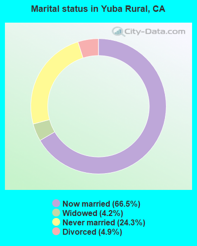
- Never married: 24.3%
- Now married: 66.5%
- Separated: 0.1%
- Widowed: 4.2%
- Divorced: 4.9%
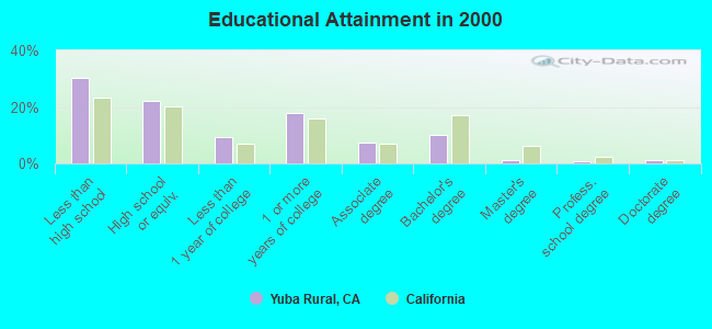
For population 25 years and over in Yuba Rural:
- High school or higher: 69.8%
- Bachelor's degree or higher: 13.1%
- Graduate or professional degree: 2.8%
- Unemployed: 6.9%
- Mean travel time to work (commute): 22.6 minutes
| Here: | 16.4 |
| California average: | 16.1 |
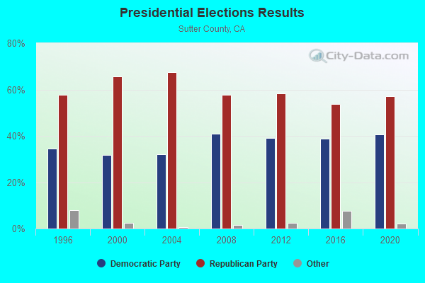
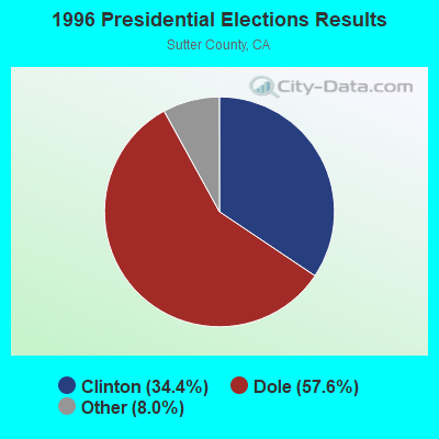
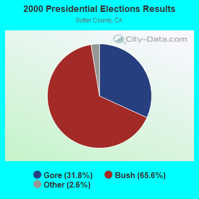
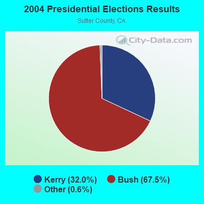
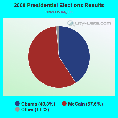
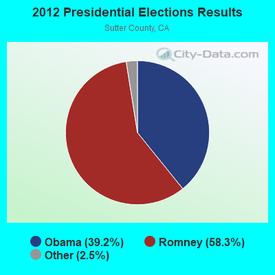
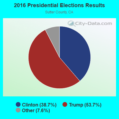
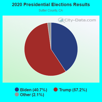
Graphs represent county-level data. Detailed 2008 Election Results
Religion statistics for Yuba Rural, CA (based on Sutter County data)
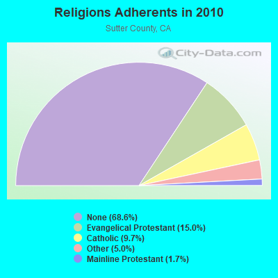
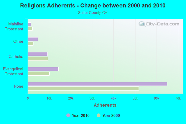
| Religion | Adherents | Congregations |
|---|---|---|
| Evangelical Protestant | 14,212 | 43 |
| Catholic | 9,181 | 3 |
| Other | 4,765 | 17 |
| Mainline Protestant | 1,624 | 7 |
| None | 64,955 | - |
Food Environment Statistics:
| Sutter County: | 2.29 / 10,000 pop. |
| California: | 2.14 / 10,000 pop. |
| Sutter County: | 0.11 / 10,000 pop. |
| California: | 0.04 / 10,000 pop. |
| Here: | 1.42 / 10,000 pop. |
| California: | 0.62 / 10,000 pop. |
| This county: | 2.08 / 10,000 pop. |
| State: | 1.49 / 10,000 pop. |
| Sutter County: | 6.66 / 10,000 pop. |
| State: | 7.42 / 10,000 pop. |
| Sutter County: | 7.4% |
| California: | 7.3% |
| Sutter County: | 24.5% |
| California: | 21.3% |
| Sutter County: | 16.2% |
| State: | 17.9% |
Strongest AM radio stations in Yuba Rural:
- KUBA (1600 AM; 5 kW; YUBA CITY, CA; Owner: HARLAN COMMUNICATIONS, INC.)
- KFBK (1530 AM; 50 kW; SACRAMENTO, CA; Owner: AMFM RADIO LICENSES, L.L.C.)
- KFIA (710 AM; 25 kW; CARMICHAEL, CA; Owner: VISTA BROADCASTING INC.)
- KMYC (1410 AM; 5 kW; MARYSVILLE, CA; Owner: THOMAS F. HUTH)
- KSTE (650 AM; 25 kW; RANCHO CORDOVA, CA; Owner: AMFM RADIO LICENSES, L.L.C.)
- KHTK (1140 AM; 50 kW; SACRAMENTO, CA; Owner: INFINITY RADIO SUBSIDIARY OPERATIONS INC.)
- KOBO (1450 AM; 1 kW; YUBA CITY, CA; Owner: MULTICULTURAL RADIO BROADCASTING INC)
- KCBS (740 AM; 50 kW; SAN FRANCISCO, CA; Owner: INFINITY BROADCASTING OPERATIONS, INC.)
- KLIB (1110 AM; 10 kW; ROSEVILLE, CA; Owner: WAY BROADCASTING, INC.)
- KAHI (950 AM; 10 kW; AUBURN, CA; Owner: IHR EDUCATIONAL BROADCASTING)
- KTRB (860 AM; 50 kW; MODESTO, CA; Owner: PAPPAS RADIO OF CALIFORNIA, A CALIFORNIA LIMITED PARTNERSHIP)
- KCBC (770 AM; 50 kW; RIVERBANK, CA; Owner: KIERTRON, INC.)
- KNBR (680 AM; 50 kW; SAN FRANCISCO, CA; Owner: KNBR LICO, INC.)
Strongest FM radio stations in Yuba Rural:
- KRCX-FM (99.9 FM; MARYSVILLE, CA; Owner: ENTRAVISION HOLDINGS, LLC)
- KMJE (101.5 FM; GRIDLEY, CA; Owner: RESULTS RADIO LICENSEE, LLC)
- K213BZ (90.5 FM; RICHVALE, CA; Owner: FAMILY STATIONS, INC.)
- KXCL (103.9 FM; YUBA CITY, CA; Owner: HARLAN COMMUNICATIONS, INC.)
- KKCY (103.1 FM; COLUSA, CA; Owner: RESULTS RADIO LICENSEE, LLC)
- KNDL (89.9 FM; ANGWIN, CA; Owner: HOWELL MOUNTAIN BROADCASTING COMPANY)
- KLVR (91.9 FM; SANTA ROSA, CA; Owner: EDUCATIONAL MEDIA FOUNDATION)
- KXTS (100.9 FM; CALISTOGA, CA; Owner: SINCLAIR TELECABLE, INC.)
- K258AQ (99.5 FM; YANKEE HILL, CA; Owner: CALVARY CHAPEL OF TWIN FALLS, INC.)
- K284AG (104.7 FM; WOODLAND, CA; Owner: EDUCATIONAL MEDIA FOUNDATION)
- KBBF (89.1 FM; SANTA ROSA, CA; Owner: BILINGUAL B/CING. FOUNDATION, INC.)
- KYIX (104.9 FM; SOUTH OROVILLE, CA; Owner: BUTTE BROADCASTING COMPANY, INC.)
- KKFS (105.5 FM; DUNNIGAN, CA; Owner: CARON BROADCASTING, INC.)
- KUIC (95.3 FM; VACAVILLE, CA; Owner: KUIC, INC.)
- KHAP (89.1 FM; CHICO, CA; Owner: FAMILY STATIONS, INC.)
- KHHZ (97.7 FM; OROVILLE, CA; Owner: CLEAR CHANNEL BROADCASTING LICENSES, INC.)
- KSXY (98.7 FM; MIDDLETOWN, CA; Owner: COMMONWEALTH BROADCASTING, LLC)
- KVMR (89.5 FM; NEVADA CITY, CA; Owner: NEVADA CITY COMMUNITY BROADCAST GRUP)
- KLVS (99.3 FM; GRASS VALLEY, CA; Owner: EDUCATIONAL MEDIA FOUNDATION)
- KNCO-FM (94.1 FM; GRASS VALLEY, CA; Owner: NEVADA COUNTY BROADCASTERS, INC.)
TV broadcast stations around Yuba Rural:
- KEZT-CA (Channel 23; SACRAMENTO, CA; Owner: TELEFUTURA SACRAMENTO LLC)
- KMMK-LP (Channel 14; SACRAMENTO, CA; Owner: CABALLERO TELEVISION TEXAS, L.L.C.)
- KSPX (Channel 29; SACRAMENTO, CA; Owner: PAXSON SACRAMENTO LICENSE, INC.)
- KTXL (Channel 40; SACRAMENTO, CA; Owner: CHANNEL 40, INC.)
- KQCA (Channel 58; STOCKTON, CA; Owner: KCRA HEARST-ARGYLE TELEVISION, INC.)
- KOVR (Channel 13; STOCKTON, CA; Owner: SCI - SACRAMENTO LICENSEE, LLC)
- KXTV (Channel 10; SACRAMENTO, CA; Owner: KXTV, INC.)
- KVIE (Channel 6; SACRAMENTO, CA; Owner: KVIE, INC.)
- KUVS (Channel 19; MODESTO, CA; Owner: KUVS LICENSE PARTNERSHIP, G.P.)
- KMAX-TV (Channel 31; SACRAMENTO, CA; Owner: UPN STATIONS GROUP INC.)
- K17EH (Channel 17; EUREKA, CA; Owner: MS COMMUNICATIONS, LLC)
- KSAO-LP (Channel 49; SACRAMENTO, CA; Owner: GARY M. COCOLA FAMILY TRUST, GARY M. COCOLA TRUSTEE)
- KBTV-LP (Channel 8; SACRAMENTO, CA; Owner: INCISOR COMMUNICATIONS, L.L.C.)
- KMUM-CA (Channel 15; SACRAMENTO, CA; Owner: CABALLERO TELEVISION TEXAS, L.L.C.)
- K69FB (Channel 69; SACRAMENTO, CA; Owner: TRINITY BROADCASTING NETWORK)
- K27FX (Channel 27; EUREKA, CA; Owner: MS COMMUNICATIONS, LLC)
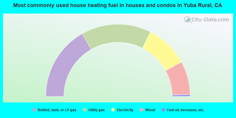
- 33.5%Bottled, tank, or LP gas
- 31.3%Utility gas
- 19.3%Electricity
- 15.0%Wood
- 0.8%Fuel oil, kerosene, etc.
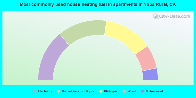
- 27.9%Electricity
- 26.6%Bottled, tank, or LP gas
- 26.3%Utility gas
- 12.8%Wood
- 6.4%No fuel used
Yuba Rural compared to California state average:
- Unemployed percentage below state average.
- Black race population percentage significantly below state average.
- Median age above state average.
- Foreign-born population percentage significantly below state average.
- Renting percentage significantly below state average.
- Length of stay since moving in significantly above state average.
- Number of rooms per house significantly below state average.
- House age significantly below state average.
- Percentage of population with a bachelor's degree or higher below state average.
Yuba Rural on our top lists:
- #57 on the list of "Top 101 cities with the most cars per house, population 500+"
- #3 on the list of "Top 101 counties with the highest Ozone (1-hour) air pollution readings in 2012 (ppm)"
- #34 on the list of "Top 101 counties with the highest Nitrogen Dioxide air pollution readings in 2012 (ppm)"
- #64 on the list of "Top 101 counties with the largest number of people moving out compared to moving in (pop. 50,000+)"
- #66 on the list of "Top 101 counties with the largest decrease in the number of deaths per 1000 residents 2000-2006 to 2007-2013 (pop. 50,000+)"
- #92 on the list of "Top 101 counties with the lowest Particulate Matter (PM2.5) Annual air pollution readings in 2012 (µg/m3)"