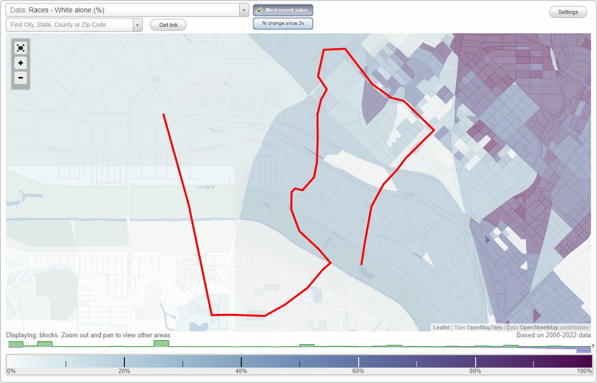
Arlington Park neighborhood in Dallas, Texas (TX), 75207, 75235, 75247 detailed profile
Settings
X

Business Search - 14 Million verified businesses
Area: 3.892 square miles
Population: 14,610
Population density:
| Arlington Park: | 3,754 people per square mile |
| Dallas: | 3,794 people per square mile |

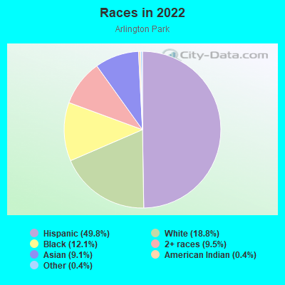
- 8,56549.8%Hispanic or Latino
- 3,23518.8%White
- 2,07512.1%Black
- 1,6319.5%Two or more races
- 1,5699.1%Asian
- 630.4%American Indian
- 630.4%Some other race
Distribution of median household income
![Distribution of median household income]()
- 682Less than $10,000
- 3,194$10,000 to $19,999
- 992$20,000 to $29,999
- 677$30,000 to $39,999
- 1,594$40,000 to $49,999
- 1,149$50,000 to $59,999
- 463$60,000 to $74,999
- 1,225$75,000 to $99,999
- 1,302$100,000 to $124,999
- 315$125,000 to $149,999
- 261$150,000 to $199,999
- 587$200,000 or more

Distribution of owner-occupied house/condo value
![Distribution of owner-occupied house/condo value]()
- 133Less than $50,000
- 444$50,000 to $99,999
- 827$100,000 to $149,999
- 566$150,000 to $199,999
- 459$200,000 to $249,999
- 750$250,000 to $299,999
- 797$300,000 to $399,999
- 414$400,000 to $499,999
- 398$500,000 to $749,999

Distribution of rent paid by renters
![Distribution of rent paid by renters]()
- 125Less than $100
- 926$100 to $199
- 1,764$200 to $299
- 794$400 to $499
- 865$500 to $599
- 326$600 to $699
- 850$700 to $799
- 648$800 to $899
- 922$900 to $999
- 515$1,000 to $1,249
- 2,366$1,250 to $1,499
- 462$1,500 to $1,999
- 703$2,000 or more

| Males: | 7,692 |
| Females: | 6,918 |
Males:
| This neighborhood: | |
| Whole city: |
| This neighborhood: | |
| Whole city: |
Percentage of family households:
| Arlington Park: | 50.9% |
| Dallas: | 42.6% |
| Here: | 43.1% |
| Dallas: | 33.8% |
Percentage of married-couple families with children (among all households):
| Arlington Park: | 23.6% |
| Dallas: | 24.8% |
Percentage of single-mother households (among all households):
| Arlington Park: | 23.3% |
| Dallas: | 13.3% |
Percentage of never married males 15 years old and over:
Percentage of never married females 15 years old and over:
| Arlington Park: | 28.1% |
| Dallas: | 22.1% |
Percentage of never married females 15 years old and over:
| Arlington Park: | 17.6% |
| city: | 21.8% |
Percentage of people that speak English not well or not at all:
| Arlington Park: | 29.9% |
| Dallas: | 10.7% |
Percentage of people born in this state:
Percentage of people born in another U.S. state:
Percentage of native residents but born outside the U.S.:
Percentage of foreign born residents:
| Here: | 50.5% |
| Dallas: | 52.8% |
Percentage of people born in another U.S. state:
| Arlington Park: | 20.5% |
| Dallas: | 22.0% |
Percentage of native residents but born outside the U.S.:
| Here: | 2.4% |
| city: | 1.3% |
Percentage of foreign born residents:
| Here: | 26.6% |
| Dallas: | 23.9% |
Owner-occupied
Renter-occupied

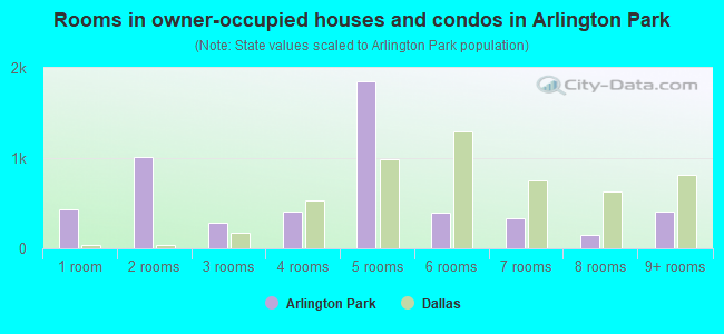
- Rooms in owner-occupied houses and condos in Arlington Park
- 4291 room
- 1,0142 rooms
- 2823 rooms
- 4134 rooms
- 1,8545 rooms
- 3986 rooms
- 3387 rooms
- 1428 rooms
- 4049+ rooms
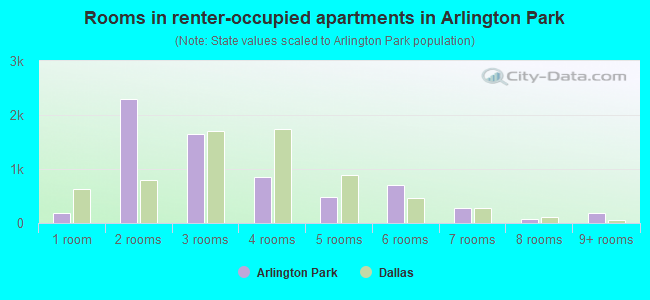
- Rooms in renter-occupied apartments in Arlington Park
- 1871 room
- 2,2982 rooms
- 1,6483 rooms
- 8504 rooms
- 4745 rooms
- 6986 rooms
- 2697 rooms
- 808 rooms
- 1919+ rooms
Owner-occupied
Renter-occupied
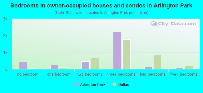
- Bedrooms in owner-occupied houses and condos in Arlington Park
- 428no bedroom
- 2681 bedroom
- 4662 bedrooms
- 2,2373 bedrooms
- 1444 bedrooms
- 1015+ bedrooms
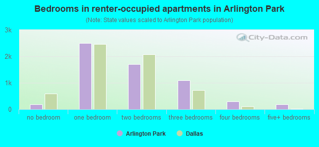
- Bedrooms in renter-occupied apartments in Arlington Park
- 187no bedroom
- 2,5091 bedroom
- 1,6972 bedrooms
- 1,0923 bedrooms
- 2934 bedrooms
- 1915+ bedrooms
Average number of cars or other vehicles available in houses/condos:
Average number of cars or other vehicles available in apartments:
| This neighborhood: | |
| Dallas: |
Average number of cars or other vehicles available in apartments:
| Here: | |
| city: |
Percentage of units with a mortgage:
| Arlington Park: | 68.7% |
| Dallas: | 53.9% |
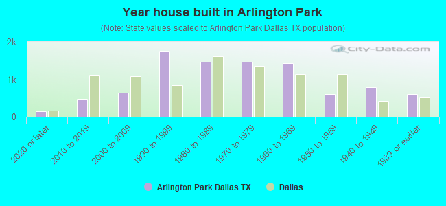
- Year house built in Arlington Park
- 1392020 or later
- 4712010 to 2019
- 6422000 to 2009
- 1,7681990 to 1999
- 1,4621980 to 1989
- 1,4741970 to 1979
- 1,4381960 to 1969
- 6091950 to 1959
- 7811940 to 1949
- 6101939 or earlier
City-data.com crime index for city in 2020 (higher means more crime):
| City: | 439.5 |
| U.S. average: | 219.5 |
Travel time to work (commute)
![Travel time to work (commute)]()
- 424Less than 5 minutes
- 1,9935 to 9 minutes
- 4,45310 to 14 minutes
- 3,46915 to 19 minutes
- 1,59620 to 24 minutes
- 1,22525 to 29 minutes
- 2,73630 to 34 minutes
- 30535 to 39 minutes
- 50240 to 44 minutes
- 25045 to 59 minutes
- 52560 to 89 minutes
- 21290 or more minutes

Means of transportation to work
![Means of transportation to work]()
- 59.5%4,504Drove a car alone
- 22.0%1,661Carpooled
- 5.2%395Bus
- 1.9%141Subway or elevated rail
- 26.6%2,012Light rail, streetcar or trolley
- 4.3%323Bicycle
- 11.6%881Walked
- 13.0%981Worked at home

Time leaving home to go to work
![Time leaving home to go to work]()
- 66712:00 a.m. to 4:59 a.m.
- 1,2195:00 a.m. to 5:29 a.m.
- 1185:30 a.m. to 5:59 a.m.
- 1,1206:00 a.m. to 6:29 a.m.
- 1,4896:30 a.m. to 6:59 a.m.
- 2,2247:00 a.m. to 7:29 a.m.
- 2,2877:30 a.m. to 7:59 a.m.
- 2,4478:00 a.m. to 8:29 a.m.
- 9358:30 a.m. to 8:59 a.m.
- 2,5009:00 a.m. to 9:59 a.m.
- 27010:00 a.m. to 10:59 a.m.
- 12711:00 a.m. to 11:59 a.m.
- 2,02612:00 p.m. to 3:59 p.m.
- 7884:00 p.m. to 11:59 p.m.

Occupations of males:
- Percentage of males in management occupations (except farmers):
Here: 10.4% city: 10.9%
- Percentage of males in computer and mathematical occupations:
Here: 2.8% city: 4.7%
- Percentage of males in architecture and engineering occupations:
Here: 1.4% city: 2.8%
- Percentage of males in community and social services occupations:
Here: 1.4% city: 0.8%
- Percentage of males in education, training, and library occupations:
Here: 2.1% city: 2.3%
- Percentage of males in arts, design, entertainment, sports, and media occupations:
Here: 3.1% city: 2.2%
- Percentage of males in service occupations:
Here: 33.6% city: 12.3%
- Percentage of males in sales and office occupations:
Here: 5.3% city: 14.9%
- Percentage of males in construction, extraction, and maintenance occupations:
Here: 10.2% city: 15.2%
- Percentage of males in production occupations:
Here: 9.7% city: 5.0%
- Percentage of males in transportation occupations:
Here: 6.9% city: 5.9%
- Percentage of males in material moving occupations:
Here: 10.6% city: 6.2%
Occupations of females:
- Percentage of females in management occupations (except farmers):
Here: 5.4% city: 9.6%
- Percentage of females in business and financial operations occupations:
Here: 6.9% city: 8.4%
- Percentage of females in computer and mathematical occupations:
Here: 10.1% city: 2.0%
- Percentage of females in architecture and engineering occupations:
Here: 2.4% city: 0.6%
- Percentage of females in life, physical, and social science occupations:
Here: 7.3% city: 0.8%
- Percentage of females in legal occupations:
Here: 3.0% city: 1.8%
- Percentage of females in education, training, and library occupations:
Here: 2.4% city: 7.1%
- Percentage of females in service occupations:
Here: 41.6% city: 20.5%
- Percentage of females in sales and office occupations:
Here: 10.2% city: 27.7%
- Percentage of females in construction, extraction, and maintenance occupations:
Here: 4.4% city: 0.6%
- Percentage of females in production occupations:
Here: 7.3% city: 3.6%
- Percentage of females in transportation occupations:
Here: 6.3% city: 1.4%
- Percentage of females in material moving occupations:
Here: 5.0% city: 3.2%
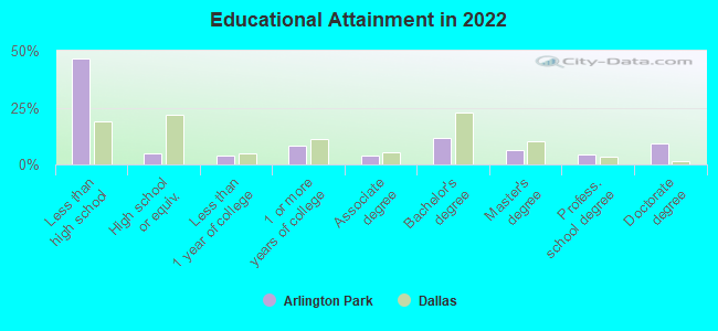
Education in this neighborhood (subdivision or community):
- Percentage of people 3 years and older in K-12 schools:
Arlington Park: 23.2% Dallas: 17.3%
- Percentage of people 3 years and older in undergraduate colleges:
Arlington Park: 11.8% Dallas: 4.1%
- Percentage of people 3 years and older in grad. or professional schools:
Arlington Park: 16.5% Dallas: 1.7%
- Percentage of students K-12 enrolled in private schools:
Arlington Park: 4.3% Dallas: 10.8%
Percentage of population below poverty level:
| Arlington Park: | 23.5% |
| Dallas: | 17.8% |
Percentage of married-couple families with both working:
| Arlington Park: | 71.3% |
| Dallas: | 58.3% |
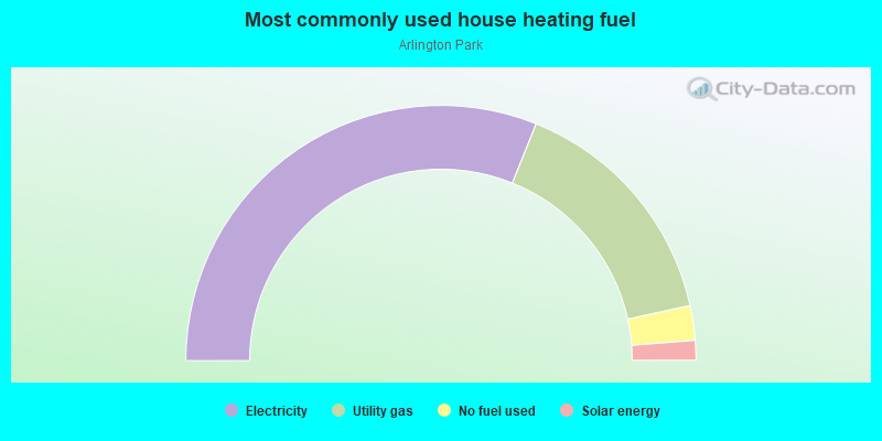
- 62.2%Electricity
- 30.9%Utility gas
- 4.4%No fuel used
- 2.5%Solar energy
Limited-access highways (interstate or state) in this neighborhood:
N Stemmons Fwy (I- 35, US Hwy 77)
Length: 5.95 miles
Directions: E-W, N-S, SE-NW
Directions: E-W, N-S, SE-NW
Highways in this neighborhood:
Irving Blvd (State Hwy 356)
Length: 5.78 miles
Directions: E-W, SE-NW
Address range: 2200 to 3299
Directions: E-W, SE-NW
Address range: 2200 to 3299
State Hwy 354 (Harry Hines Blvd)
Length: 1.75 miles
Directions: E-W, N-S, SE-NW
Address range: 4482 to 6099
Directions: E-W, N-S, SE-NW
Address range: 4482 to 6099
E John Carpenter Fwy (State Hwy 183)
Length: 0.73 miles
Directions: E-W, SE-NW
Address range: 7300 to 7559
Directions: E-W, SE-NW
Address range: 7300 to 7559
State Hwy 356
Length: 0.03 miles
Directions: N-S, SE-NW
Directions: N-S, SE-NW
Roads and streets:
Inwood Rd
Length: 3.17 miles
Directions: E-W, N-S, SW-NE
Address range: 1200 to 2499
Directions: E-W, N-S, SW-NE
Address range: 1200 to 2499
Levee Rd
Length: 2.95 miles
Directions: E-W, SE-NW
Directions: E-W, SE-NW
Motor St
Length: 1.66 miles
Directions: E-W, N-S, SW-NE
Address range: 1934 to 2499
Directions: E-W, N-S, SW-NE
Address range: 1934 to 2499
Commonwealth Dr
Length: 1.34 miles
Directions: E-W, N-S, SE-NW, SW-NE
Directions: E-W, N-S, SE-NW, SW-NE
W Mockingbird Ln
Length: 1.27 miles
Directions: N-S, SW-NE
Address range: 300 to 1219
Directions: N-S, SW-NE
Address range: 300 to 1219
Maple Ave
Length: 1.25 miles
Directions: E-W, SE-NW
Address range: 4424 to 5699
Directions: E-W, SE-NW
Address range: 4424 to 5699
Wycliff Ave
Length: 1.24 miles
Directions: E-W, N-S, SW-NE
Address range: 1200 to 1799
Directions: E-W, N-S, SW-NE
Address range: 1200 to 1799
Medical Center Dr
Length: 0.87 miles
Directions: E-W, N-S, SE-NW
Address range: 5000 to 5699
Directions: E-W, N-S, SE-NW
Address range: 5000 to 5699
Butler St
Length: 0.85 miles
Directions: E-W, SW-NE
Address range: 2100 to 2499
Directions: E-W, SW-NE
Address range: 2100 to 2499
Campus
Length: 0.85 miles
Directions: E-W, N-S, SE-NW, SW-NE
Directions: E-W, N-S, SE-NW, SW-NE
Quebec St
Length: 0.83 miles
Direction: E-W
Address range: 3000 to 3399
Direction: E-W
Address range: 3000 to 3399
Record Crossing Rd
Length: 0.82 miles
Directions: E-W, SW-NE
Address range: 1550 to 2099
Directions: E-W, SW-NE
Address range: 1550 to 2099
Halifax St
Length: 0.63 miles
Direction: E-W
Address range: 3000 to 3299
Direction: E-W
Address range: 3000 to 3299
Lucas Dr
Length: 0.62 miles
Directions: N-S, SW-NE
Address range: 2001 to 2499
Directions: N-S, SW-NE
Address range: 2001 to 2499
Redfield St
Length: 0.60 miles
Directions: N-S, SE-NW
Address range: 5100 to 5699
Directions: N-S, SE-NW
Address range: 5100 to 5699
Lakawana St
Length: 0.58 miles
Directions: N-S, SW-NE
Address range: 4800 to 5199
Directions: N-S, SW-NE
Address range: 4800 to 5199
Inwood Ramp
Length: 0.58 miles
Directions: E-W, N-S, SE-NW, SW-NE
Address range: 2000 to 2159
Directions: E-W, N-S, SE-NW, SW-NE
Address range: 2000 to 2159
Iron Ridge St
Length: 0.56 miles
Directions: E-W, N-S, SE-NW, SW-NE
Address range: 2900 to 3199
Directions: E-W, N-S, SE-NW, SW-NE
Address range: 2900 to 3199
Sharp St
Length: 0.56 miles
Direction: N-S
Address range: 4700 to 5199
Direction: N-S
Address range: 4700 to 5199
Calvert St
Length: 0.55 miles
Direction: N-S
Address range: 4700 to 5199
Direction: N-S
Address range: 4700 to 5199
St Vincents Dr
Length: 0.54 miles
Directions: E-W, N-S, SE-NW, SW-NE
Address range: 5900 to 5999
Directions: E-W, N-S, SE-NW, SW-NE
Address range: 5900 to 5999
Chattanooga Pl
Length: 0.54 miles
Direction: E-W
Address range: 1600 to 1999
Direction: E-W
Address range: 1600 to 1999
Arroyo Ave
Length: 0.52 miles
Direction: SW-NE
Address range: 2100 to 2499
Direction: SW-NE
Address range: 2100 to 2499
Farrington St
Length: 0.51 miles
Direction: SE-NW
Address range: 2300 to 2498
Direction: SE-NW
Address range: 2300 to 2498
Woodall St
Length: 0.51 miles
Direction: N-S
Address range: 4800 to 5199
Direction: N-S
Address range: 4800 to 5199
Conveyor Ln
Length: 0.45 miles
Directions: E-W, N-S, SW-NE
Address range: 1100 to 1299
Directions: E-W, N-S, SW-NE
Address range: 1100 to 1299
Briar Cliff Rd
Length: 0.45 miles
Directions: E-W, SE-NW
Address range: 1400 to 1698
Directions: E-W, SE-NW
Address range: 1400 to 1698
Arlington Park Dr
Length: 0.43 miles
Directions: E-W, N-S, SE-NW, SW-NE
Address range: 5500 to 5899
Directions: E-W, N-S, SE-NW, SW-NE
Address range: 5500 to 5899
Afton St
Length: 0.43 miles
Directions: N-S, SE-NW
Address range: 2000 to 4699
Directions: N-S, SE-NW
Address range: 2000 to 4699
Harry Hines Blvd Rmp
Length: 0.42 miles
Directions: E-W, N-S, SE-NW, SW-NE
Address range: 5570 to 5829
Directions: E-W, N-S, SE-NW, SW-NE
Address range: 5570 to 5829
Envoy Ct
Length: 0.39 miles
Directions: E-W, N-S, SE-NW, SW-NE
Address range: 7100 to 7299
Directions: E-W, N-S, SE-NW, SW-NE
Address range: 7100 to 7299
Mississippi Ave
Length: 0.39 miles
Directions: E-W, SE-NW
Address range: 1000 to 1299
Directions: E-W, SE-NW
Address range: 1000 to 1299
Irving Blvd Svc Rd N
Length: 0.38 miles
Direction: E-W
Address range: 3100 to 3299
Direction: E-W
Address range: 3100 to 3299
Carnation St
Length: 0.37 miles
Directions: E-W, N-S, SE-NW
Address range: 5700 to 5999
Directions: E-W, N-S, SE-NW
Address range: 5700 to 5999
Gretna St
Length: 0.35 miles
Direction: N-S
Address range: 4700 to 4899
Direction: N-S
Address range: 4700 to 4899
Kings Rd
Length: 0.34 miles
Directions: N-S, SW-NE
Address range: 2158 to 2499
Directions: N-S, SW-NE
Address range: 2158 to 2499
Burgess Blvd
Length: 0.34 miles
Direction: E-W
Address range: 1100 to 1299
Direction: E-W
Address range: 1100 to 1299
Crampton St
Length: 0.33 miles
Direction: SW-NE
Address range: 1200 to 1499
Direction: SW-NE
Address range: 1200 to 1499
Vicksburg St
Length: 0.33 miles
Direction: N-S
Address range: 4700 to 4999
Direction: N-S
Address range: 4700 to 4999
Lake Ave
Length: 0.33 miles
Direction: SE-NW
Address range: 4500 to 4799
Direction: SE-NW
Address range: 4500 to 4799
Sylvester St
Length: 0.32 miles
Direction: SE-NW
Address range: 4450 to 4799
Direction: SE-NW
Address range: 4450 to 4799
Hawthorne Ave
Length: 0.32 miles
Direction: SW-NE
Address range: 2100 to 2499
Direction: SW-NE
Address range: 2100 to 2499
Security Dr
Length: 0.32 miles
Directions: E-W, N-S
Address range: 1100 to 1299
Directions: E-W, N-S
Address range: 1100 to 1299
Memphis St
Length: 0.31 miles
Direction: N-S
Address range: 4700 to 4899
Direction: N-S
Address range: 4700 to 4899
Mesa Cir
Length: 0.30 miles
Directions: E-W, N-S, SE-NW
Address range: 5500 to 5999
Directions: E-W, N-S, SE-NW
Address range: 5500 to 5999
Lucky Ln
Length: 0.29 miles
Direction: N-S
Address range: 4700 to 4899
Direction: N-S
Address range: 4700 to 4899
Access Rd
Length: 0.27 miles
Direction: E-W
Direction: E-W
Reading St
Length: 0.26 miles
Direction: N-S
Address range: 4800 to 4999
Direction: N-S
Address range: 4800 to 4999
Production Dr
Length: 0.26 miles
Direction: SE-NW
Address range: 4500 to 4699
Direction: SE-NW
Address range: 4500 to 4699
Valdina St
Length: 0.26 miles
Directions: E-W, SE-NW
Address range: 2200 to 2399
Directions: E-W, SE-NW
Address range: 2200 to 2399
Wayside Dr
Length: 0.26 miles
Directions: E-W, N-S, SE-NW
Address range: 5500 to 5799
Directions: E-W, N-S, SE-NW
Address range: 5500 to 5799
Quaker St
Length: 0.25 miles
Directions: E-W, SW-NE
Address range: 1000 to 1199
Directions: E-W, SW-NE
Address range: 1000 to 1199
Riverside Dr
Length: 0.25 miles
Directions: N-S, SE-NW, SW-NE
Address range: 5500 to 5899
Directions: N-S, SE-NW, SW-NE
Address range: 5500 to 5899
Dolton Dr
Length: 0.24 miles
Directions: E-W, SW-NE
Address range: 1200 to 1299
Directions: E-W, SW-NE
Address range: 1200 to 1299
Algiers St
Length: 0.23 miles
Direction: N-S
Address range: 4700 to 4899
Direction: N-S
Address range: 4700 to 4899
Prairie View Dr
Length: 0.23 miles
Directions: E-W, N-S
Address range: 1800 to 1999
Directions: E-W, N-S
Address range: 1800 to 1999
Bengal St
Length: 0.23 miles
Directions: N-S, SE-NW, SW-NE
Address range: 4700 to 4999
Directions: N-S, SE-NW, SW-NE
Address range: 4700 to 4999
Vantage St
Length: 0.22 miles
Directions: E-W, SE-NW
Address range: 2200 to 2299
Directions: E-W, SE-NW
Address range: 2200 to 2299
Pegasus Park Dr (Diamond Park Dr)
Length: 0.21 miles
Directions: E-W, N-S, SE-NW
Directions: E-W, N-S, SE-NW
Lupo Dr
Length: 0.21 miles
Directions: E-W, SE-NW
Address range: 1000 to 1298
Directions: E-W, SE-NW
Address range: 1000 to 1298
Lee Hall Dr
Length: 0.21 miles
Directions: N-S, SW-NE
Address range: 5600 to 5899
Directions: N-S, SW-NE
Address range: 5600 to 5899
Monitor St
Length: 0.20 miles
Directions: E-W, SE-NW
Address range: 2200 to 2299
Directions: E-W, SE-NW
Address range: 2200 to 2299
Pickfair Cir
Length: 0.20 miles
Directions: E-W, N-S, SW-NE
Address range: 5500 to 5799
Directions: E-W, N-S, SW-NE
Address range: 5500 to 5799
Kendall Dr
Length: 0.20 miles
Direction: SW-NE
Address range: 2000 to 2099
Direction: SW-NE
Address range: 2000 to 2099
Iberia Ave
Length: 0.19 miles
Direction: N-S
Address range: 4700 to 4899
Direction: N-S
Address range: 4700 to 4899
Tex Oak Ave
Length: 0.19 miles
Direction: SE-NW
Address range: 5200 to 5399
Direction: SE-NW
Address range: 5200 to 5399
N Industrial Blvd (Market Center Blvd)
Length: 0.18 miles
Directions: N-S, SE-NW, SW-NE
Address range: 2419 to 2520
Directions: N-S, SE-NW, SW-NE
Address range: 2419 to 2520
Converse St
Length: 0.18 miles
Directions: E-W, SE-NW
Address range: 2400 to 2599
Directions: E-W, SE-NW
Address range: 2400 to 2599
Sylvan Ave
Length: 0.17 miles
Direction: N-S
Address range: 3750 to 3899
Direction: N-S
Address range: 3750 to 3899
Lofland St
Length: 0.16 miles
Direction: SW-NE
Address range: 2100 to 2199
Direction: SW-NE
Address range: 2100 to 2199
Conant St
Length: 0.15 miles
Directions: N-S, SE-NW, SW-NE
Address range: 1300 to 1399
Directions: N-S, SE-NW, SW-NE
Address range: 1300 to 1399
N Stemmons Fwy
Length: 0.15 miles
Direction: E-W
Direction: E-W
Gregg St
Length: 0.15 miles
Direction: SE-NW
Address range: 5400 to 5599
Direction: SE-NW
Address range: 5400 to 5599
Chemical St
Length: 0.14 miles
Direction: SW-NE
Address range: 1300 to 1399
Direction: SW-NE
Address range: 1300 to 1399
Cass St
Length: 0.14 miles
Direction: SE-NW
Address range: 4700 to 4999
Direction: SE-NW
Address range: 4700 to 4999
Lagoon Dr
Length: 0.13 miles
Directions: N-S, SE-NW
Address range: 1100 to 1199
Directions: N-S, SE-NW
Address range: 1100 to 1199
Ambassador Row
Length: 0.12 miles
Direction: SE-NW
Address range: 7300 to 7455
Direction: SE-NW
Address range: 7300 to 7455
Amelia Ct
Length: 0.11 miles
Directions: E-W, N-S, SE-NW, SW-NE
Address range: 1900 to 1999
Directions: E-W, N-S, SE-NW, SW-NE
Address range: 1900 to 1999
Motor Cir
Length: 0.10 miles
Direction: SE-NW
Address range: 1300 to 1399
Direction: SE-NW
Address range: 1300 to 1399
Stansal
Length: 0.09 miles
Direction: E-W
Address range: 3000 to 3099
Direction: E-W
Address range: 3000 to 3099
Ok Ave
Length: 0.09 miles
Direction: SE-NW
Address range: 5300 to 5399
Direction: SE-NW
Address range: 5300 to 5399
Longpoint Ave
Length: 0.09 miles
Direction: N-S
Address range: 1100 to 1199
Direction: N-S
Address range: 1100 to 1199
Pump Plant B Rd
Length: 0.09 miles
Direction: SW-NE
Address range: 100 to 199
Direction: SW-NE
Address range: 100 to 199
N Westmoreland Rd
Length: 0.08 miles
Direction: N-S
Address range: 4600 to 4725
Direction: N-S
Address range: 4600 to 4725
Tully St
Length: 0.07 miles
Directions: E-W, SW-NE
Address range: 2200 to 2399
Directions: E-W, SW-NE
Address range: 2200 to 2399
Macatee Dr
Length: 0.07 miles
Direction: SW-NE
Address range: 2150 to 2199
Direction: SW-NE
Address range: 2150 to 2199
Acorn Ct
Length: 0.07 miles
Direction: N-S
Address range: 5800 to 5899
Direction: N-S
Address range: 5800 to 5899
Rosewood Ave
Length: 0.05 miles
Direction: SE-NW
Address range: 4450 to 4499
Direction: SE-NW
Address range: 4450 to 4499
Jane Ln
Length: 0.04 miles
Direction: E-W
Address range: 3300 to 3435
Direction: E-W
Address range: 3300 to 3435
Doug Dr
Length: 0.04 miles
Direction: E-W
Address range: 3300 to 3402
Direction: E-W
Address range: 3300 to 3402
Commonwealth Svc Rd N
Length: 0.04 miles
Direction: E-W
Address range: 3176 to 3179
Direction: E-W
Address range: 3176 to 3179
Railroad features:
Chicago Rock Island and Pacific RR
Length: 5.87 miles
Directions: E-W, N-S, SE-NW, SW-NE
Directions: E-W, N-S, SE-NW, SW-NE
Texas and Pacific Rlwy
Length: 2.86 miles
Directions: E-W, SE-NW
Directions: E-W, SE-NW
Missouri-Kansas-Texas RR
Length: 2.11 miles
Directions: N-S, SE-NW, SW-NE
Directions: N-S, SE-NW, SW-NE
Chicago Rock Island & Pacific RR Spur
Length: 0.07 miles
Directions: N-S, SE-NW, SW-NE
Directions: N-S, SE-NW, SW-NE
Other features:
Elm Fork Trinity Riv
Length: 4.08 miles
Directions: E-W, N-S, SE-NW, SW-NE
Directions: E-W, N-S, SE-NW, SW-NE
Knights Br
Length: 0.97 miles
Directions: E-W, N-S, SE-NW, SW-NE
Directions: E-W, N-S, SE-NW, SW-NE
Cedar Br
Length: 0.74 miles
Directions: E-W, N-S, SE-NW, SW-NE
Directions: E-W, N-S, SE-NW, SW-NE