Bridge Statistics for Albany, Georgia (GA)
Condition, Traffic, Stress, Structural Evaluation, Project Costs
- National Bridge Inventory (NBI) Statistics
- 105Number of bridges
- 1,864ft / 568mTotal length
- $294,026,000Total costs
- 2,028,484Total average daily traffic
- 60,882Total average daily truck traffic
- National Bridge Inventory (NBI) Registered Bridges for Albany
- No street view available for this location
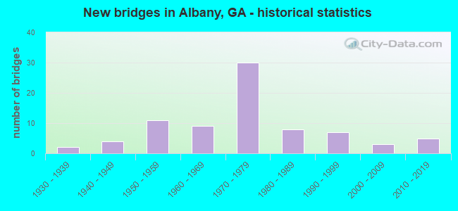
- New bridges - historical statistics
- 21930-1939
- 41940-1949
- 111950-1959
- 91960-1969
- 301970-1979
- 81980-1989
- 71990-1999
- 32000-2009
- 52010-2019

- Reconstructed bridges - Historical Statistics
- 11950-1959
- 01960-1969
- 01970-1979
- 31980-1989
- 01990-1999
- 12000-2009


- Bridge Condition - Deck
- 82.5%Good
- 17.5%Satisfactory

- Bridge Condition - Superstructure
- 38.1%Very good
- 54.0%Good
- 7.9%Satisfactory

- Bridge Condition - Substructure
- 1.6%Very good
- 87.3%Good
- 9.5%Satisfactory
- 1.6%Critical

- Bridge Condition - Channel
- 2.5%Excellent
- 52.5%Very good
- 25.0%Good
- 17.5%Satisfactory
- 2.5%Fair

- Bridge Condition - Culverts
- 93.8%Good
- 6.3%Satisfactory
Find on map >> Show street view
Structure Number: 2GA1475, Location: 0.1 KM E OF WEST SHAW RD (Lat: 31.551111, Lng: -84.092917), Route carried "on" structure: ServiceOther road , Year Built: 1957, Status: Posted for load, Structure Length: 2.47m (8.10ft), Average Daily Traffic: 10 (year 2013), Truck Traffic: 5%, Average Future Daily Traffic: 12 (year 2032), Features Intersected: DRAINAGE DITCH, Facility Carried by Structure: DIRT ACCESS ROAD
Minimum Vertical Clearance: 30+ m (98+ ft), Kilometerpoint: 0.000, Lanes on structure: 2, Owner: Navy/Marines, Approaching Roadway Width: 3.7m (12.1ft), Material/Design: Concrete, Design/Construction: Channel Beam, Number Of Spans In Main Unit: 4, Length of Maximum Span: 6.2m (20.3ft), Curb or Sidewalk Widths: Left: 0.2m (0.7ft), Right: 0.2m (0.7ft), Curb-To-Curb Width: 7.3m (24.0ft), Out-to-Out Width: 7.7m (25.3ft)
Condition: Deck: Satisfactory, Superstructure: Satisfactory, Substructure: Satisfactory, Channel: Very good, Operating Rating: 41.4 metric tons, Method Used To Determine Operating Rating: Load Factor (LF), Inventory Rating: 24.8 metric tons, Method Used To Determine Inventory Rating: Load Factor (LF), Structural Evaluation: Equal to present minimum criteria, Deck Geometry: Equal to present minimum criteria, Waterway Adequacy: Equal to present desirable criteria, Approach Roadway Alignment: Meets minimum limits, Length Of Structure Improvement: 2.47m (8.10ft), Designated Inspection Frequency: Every 24 months, Inspection Date: April 2021, Bridge Improvement Cost: $5,000, Roadway Improvement Cost: $33,000, Total Project Cost: $38,000 ( Estimate for 2021), Deck Structure Type: Concrete Precast Panels
Find on map >> Show street view
Structure Number: 2GA1802, Location: 1.0 KM S OF WILKINSON WAY (Lat: 31.547639, Lng: -84.095111), Route carried "on" structure: ServiceOther road , Year Built: 1957, Status: Posted for load, Structure Length: 3.09m (10.14ft), Average Daily Traffic: 50 (year 2013), Truck Traffic: 5%, Average Future Daily Traffic: 60 (year 2032), Features Intersected: DRAINAGE DITCH, Facility Carried by Structure: WEST SHAW ROAD
Minimum Vertical Clearance: 30+ m (98+ ft), Kilometerpoint: 0.000, Lanes on structure: 1, Owner: Navy/Marines, Approaching Roadway Width: 3.7m (12.1ft), Material/Design: Concrete, Design/Construction: Channel Beam, Number Of Spans In Main Unit: 5, Length of Maximum Span: 6.2m (20.3ft), Curb or Sidewalk Widths: Left: 0.2m (0.7ft), Right: 0.2m (0.7ft), Curb-To-Curb Width: 3.4m (11.2ft), Out-to-Out Width: 3.8m (12.5ft)
Condition: Deck: Satisfactory, Superstructure: Satisfactory, Substructure: Satisfactory, Channel: Satisfactory, Operating Rating: 43.7 metric tons, Method Used To Determine Operating Rating: Load Factor (LF), Inventory Rating: 26.3 metric tons, Method Used To Determine Inventory Rating: Load Factor (LF), Structural Evaluation: Equal to present minimum criteria, Deck Geometry: High priority of corrective action, Waterway Adequacy: Equal to present desirable criteria, Approach Roadway Alignment: Equal to present minimum criteria, Length Of Structure Improvement: 3.09m (10.14ft), Designated Inspection Frequency: Every 24 months, Inspection Date: April 2021, Bridge Improvement Cost: $2,000, Roadway Improvement Cost: $21,000, Total Project Cost: $23,000 ( Estimate for 2021), Deck Structure Type: Concrete Precast Panels
Find on map >> Show street view
Structure Number: 95001, Location: 2 MI NE OF MILLEDGEVILLE (Lat: 33.108819, Lng: -83.213081), Route carried "on" structure: City street 685, Year Built: 1960, Status: Posted for load, Structure Length: 2.74m (8.99ft), Average Daily Traffic: 1,096 (year 2011), Truck Traffic: 1%, Average Future Daily Traffic: 1,644 (year 2031), Design Load: H 15, Features Intersected: TOBLER CREEK, Facility Carried by Structure: BARROWS FERRY RD
Minimum Vertical Clearance: 30+ m (98+ ft), Kilometerpoint: 3.219, Lanes on structure: 2, Base Highway Network: Yes, Owner: City or Municipal Highway Agency, Approaching Roadway Width: 6.4m (21.0ft), Material/Design: Concrete, Design/Construction: Slab, Number Of Spans In Main Unit: 6, Length of Maximum Span: 4.6m (15.1ft), Curb-To-Curb Width: 7.3m (24.0ft), Out-to-Out Width: 7.7m (25.3ft)
Condition: Deck: Satisfactory, Superstructure: Satisfactory, Substructure: Critical, Channel: Satisfactory, Structural Evaluation: High priority of replacement, Deck Geometry: Meets minimum limits, Waterway Adequacy: Equal to present desirable criteria, Approach Roadway Alignment: Better than present minimum criteria, Bridge Posting: Required (Relationship of Operating Rating to Maximum Legal Load: 10.0 - 19.9% below), Length Of Structure Improvement: 42.98m (141.01ft), Designated Inspection Frequency: Every 24 months, Inspection Date: March 2020, Bridge Improvement Cost: $352,000, Roadway Improvement Cost: $35,000, Total Project Cost: $527,000, Deck Structure Type: Concrete Precast Panels
Find on map >> Show street view
Structure Number: 95002, Location: 4.5 MI SW OF MILLEDGEVILL (Lat: 33.068486, Lng: -83.302828), Route carried "on" structure: County highway 66, Year Built: 1960, Status: Open, Structure Length: 4.88m (16.01ft), Average Daily Traffic: 790 (year 2011), Truck Traffic: 1%, Average Future Daily Traffic: 1,185 (year 2031), Design Load: H 15, Features Intersected: FISHING CREEK, Facility Carried by Structure: HORACE VEAL ROAD
Minimum Vertical Clearance: 30+ m (98+ ft), Kilometerpoint: 1.609, Lanes on structure: 2, Base Highway Network: Yes, Owner: County Highway Agency, Approaching Roadway Width: 6.1m (20.0ft), Material/Design: Concrete, Design/Construction: Slab, Number Of Spans In Main Unit: 8, Length of Maximum Span: 6.1m (20.0ft), Curb or Sidewalk Widths: Left: 0.2m (0.7ft), Right: 0.2m (0.7ft), Curb-To-Curb Width: 7.3m (24.0ft), Out-to-Out Width: 7.6m (24.9ft)
Condition: Deck: Good, Superstructure: Good, Substructure: Good, Channel: Satisfactory, Operating Rating: 44.4 metric tons, Method Used To Determine Operating Rating: Load Factor (LF), Inventory Rating: 26.3 metric tons, Method Used To Determine Inventory Rating: Load Factor (LF), Structural Evaluation: Equal to present minimum criteria, Deck Geometry: Meets minimum limits, Waterway Adequacy: Better than present minimum criteria, Approach Roadway Alignment: Equal to present desirable criteria, Length Of Structure Improvement: 11.46m (37.60ft), Designated Inspection Frequency: Every 24 months, Inspection Date: March 2020, Bridge Improvement Cost: $625,000, Roadway Improvement Cost: $63,000, Total Project Cost: $938,000, Deck Structure Type: Concrete Precast Panels
Find on map >> Show street view
Structure Number: 95005, Location: 8.7 MI W OF MILLEDGEVILLE (Lat: 33.059231, Lng: -83.374528), Route carried "on" structure: County highway 69, Year Built: 1982, Status: Open, Structure Length: 0.88m (2.89ft), Average Daily Traffic: 340 (year 2011), Truck Traffic: 1%, Average Future Daily Traffic: 510 (year 2031), Design Load: HS 20+Mod, Features Intersected: MOORE CREEK, Facility Carried by Structure: BROWNS CROSSING RD
Minimum Vertical Clearance: 30+ m (98+ ft), Kilometerpoint: 6.437, Lanes on structure: 2, Base Highway Network: Yes, Owner: County Highway Agency, Approaching Roadway Width: 6.4m (21.0ft), Material/Design: Concrete, Design/Construction: Culvert, Number Of Spans In Main Unit: 3, Length of Maximum Span: 2.7m (8.9ft)
Condition: Channel: Satisfactory, Culverts: Good, Operating Rating: 55.3 metric tons, Method Used To Determine Operating Rating: Field evaluation and documented engineering judgment, Inventory Rating: 32.6 metric tons, Method Used To Determine Inventory Rating: Field evaluation and documented engineering judgment, Structural Evaluation: Better than present minimum criteria, Waterway Adequacy: Equal to present desirable criteria, Approach Roadway Alignment: Equal to present desirable criteria, Designated Inspection Frequency: Every 24 months, Inspection Date: March 2020, Bridge Improvement Cost: $113,000, Roadway Improvement Cost: $11,000, Total Project Cost: $170,000
Find on map >> Show street view
Structure Number: 95008, Location: 10 MI NW OF MILLEDGEVILLE (Lat: 33.121728, Lng: -83.389547), Route carried "on" structure: County highway 86, Year Built: 1980, Status: Open, Structure Length: 0.64m (2.10ft), Average Daily Traffic: 104 (year 2011), Truck Traffic: 1%, Average Future Daily Traffic: 156 (year 2031), Design Load: HS 20+Mod, Features Intersected: SAND CREEK TRIB, Facility Carried by Structure: CHRISTMAS LANE
Minimum Vertical Clearance: 30+ m (98+ ft), Kilometerpoint: 0.000, Lanes on structure: 2, Base Highway Network: Yes, Owner: County Highway Agency, Approaching Roadway Width: 9.1m (29.9ft), Skew: 1 degrees, Material/Design: Concrete, Design/Construction: Culvert, Number Of Spans In Main Unit: 3, Length of Maximum Span: 1.8m (5.9ft)
Condition: Channel: Very good, Culverts: Good, Operating Rating: 55.3 metric tons, Method Used To Determine Operating Rating: Field evaluation and documented engineering judgment, Inventory Rating: 32.6 metric tons, Method Used To Determine Inventory Rating: Field evaluation and documented engineering judgment, Structural Evaluation: Better than present minimum criteria, Waterway Adequacy: Equal to present desirable criteria, Approach Roadway Alignment: Equal to present desirable criteria, Designated Inspection Frequency: Every 24 months, Inspection Date: March 2020, Bridge Improvement Cost: $82,000, Roadway Improvement Cost: $8,000, Total Project Cost: $123,000
Find on map >> Show street view
Structure Number: 950002, Location: ALBANY - SOUTHSIDE (Lat: 31.539381, Lng: -84.136206), Route carried "on" structure: City street 114, Year Built: 1930, Status: Open, Structure Length: 1.04m (3.41ft), Average Daily Traffic: 5,480 (year 2012), Truck Traffic: 1%, Average Future Daily Traffic: 8,220 (year 2032), Design Load: H 15, Features Intersected: MARINE CORP CANAL, Facility Carried by Structure: RADIUM SPRINGS ROA
Minimum Vertical Clearance: 30+ m (98+ ft), Kilometerpoint: 3.219, Lanes on structure: 2, Base Highway Network: Yes, Owner: City or Municipal Highway Agency, Approaching Roadway Width: 8.8m (28.9ft), Skew: 1 degrees, Material/Design: Concrete, Design/Construction: Culvert, Number Of Spans In Main Unit: 3, Length of Maximum Span: 3.4m (11.2ft)
Condition: Channel: Satisfactory, Culverts: Satisfactory, Operating Rating: 41.7 metric tons, Method Used To Determine Operating Rating: Field evaluation and documented engineering judgment, Inventory Rating: 24.4 metric tons, Method Used To Determine Inventory Rating: Field evaluation and documented engineering judgment, Structural Evaluation: Equal to present minimum criteria, Waterway Adequacy: Equal to present minimum criteria, Approach Roadway Alignment: Equal to present minimum criteria, Designated Inspection Frequency: Every 24 months, Inspection Date: November 2021, Bridge Improvement Cost: $133,000, Roadway Improvement Cost: $13,000, Total Project Cost: $199,000
Find on map >> Show street view
Structure Number: 950003, Location: OGLETHORPE BOULEVARD (Lat: 31.575431, Lng: -84.147367), Route carried "on" structure: Business US 19, Year Built: 1953, Status: Open, Structure Length: 21.95m (72.01ft), Average Daily Traffic: 30,100 (year 2012), Truck Traffic: 4%, Average Future Daily Traffic: 45,150 (year 2032), Design Load: HS 20, Features Intersected: FLINT RIVER, Facility Carried by Structure: SR 520 BUSINESS
Minimum Vertical Clearance: 30+ m (98+ ft), Kilometerpoint: 8.047, Lanes on structure: 4, Base Highway Network: Yes, Owner: State Highway Agency, Approaching Roadway Width: 20.1m (65.9ft), Skew: 20 degrees, Material/Design: Steel continuous, Design/Construction: Stringer/Multi-beam, Number Of Spans In Main Unit: 10, Length of Maximum Span: 30.5m (100.1ft), Curb or Sidewalk Widths: Left: 1.5m (4.9ft), Right: 1.5m (4.9ft), Curb-To-Curb Width: 16.5m (54.1ft), Out-to-Out Width: 21.1m (69.2ft)
Condition: Deck: Good, Superstructure: Good, Substructure: Satisfactory, Channel: Good, Operating Rating: 37.1 metric tons, Method Used To Determine Operating Rating: Load Factor (LF), Inventory Rating: 22.6 metric tons, Method Used To Determine Inventory Rating: Load Factor (LF), Structural Evaluation: Somewhat better than minimum adequacy, Deck Geometry: Meets minimum limits, Waterway Adequacy: Equal to present desirable criteria, Approach Roadway Alignment: Equal to present desirable criteria, Designated Inspection Frequency: Every 24 months, Underwater Inspection Frequency: Every 60 months, Inspection Date: October 2021, Underwater Inspection Date: August 2021, Bridge Improvement Cost: $4,348,000, Roadway Improvement Cost: $435,000, Total Project Cost: $6,521,000, Deck Structure Type: Concrete Cast-file-Place
Find on map >> Show street view
Structure Number: 950004, Location: ALBANY - NORTHSIDE (Lat: 31.616478, Lng: -84.182319), Route carried "on" structure: US 82, Year Built: 1979, Status: Open, Structure Length: 6.77m (22.21ft), Average Daily Traffic: 33,850 (year 2012), Truck Traffic: 7%, Average Future Daily Traffic: 50,775 (year 2032), Design Load: HS 20+Mod, Features Intersected: M-149 PALMYRA ROAD
Minimum Vertical Clearance: 30+ m (98+ ft), Kilometerpoint: 3.219, Lanes on structure: 2, Lanes under structure: 4, Base Highway Network: Yes, Owner: State Highway Agency, Approaching Roadway Width: 12.8m (42.0ft), Skew: 14 degrees, Material/Design: Steel continuous, Design/Construction: Stringer/Multi-beam, Number Of Spans In Main Unit: 3, Length of Maximum Span: 30.5m (100.1ft), Curb-To-Curb Width: 13.0m (42.7ft), Out-to-Out Width: 13.8m (45.3ft)
Condition: Deck: Good, Superstructure: Very good, Substructure: Good, Operating Rating: 28.1 metric tons, Method Used To Determine Operating Rating: Load Factor (LF), Inventory Rating: 17.2 metric tons, Method Used To Determine Inventory Rating: Load Factor (LF), Structural Evaluation: Meets minimum limits, Deck Geometry: Superior to present desirable criteria, Underclear: Meets minimum limits, Approach Roadway Alignment: Equal to present desirable criteria, Designated Inspection Frequency: Every 24 months, Inspection Date: November 2021, Bridge Improvement Cost: $867,000, Roadway Improvement Cost: $87,000, Total Project Cost: $1,301,000, Deck Structure Type: Concrete Cast-file-Place
Find on map >> Show street view
Structure Number: 950005, Location: NORTHWEST- ALBANY (Lat: 31.616639, Lng: -84.182619), Route carried "on" structure: US 82, Year Built: 1979, Status: Open, Structure Length: 6.77m (22.21ft), Average Daily Traffic: 33,850 (year 2012), Truck Traffic: 7%, Average Future Daily Traffic: 50,775 (year 2032), Design Load: HS 20+Mod, Features Intersected: M-149 PALMYRA ROAD
Minimum Vertical Clearance: 30+ m (98+ ft), Kilometerpoint: 3.219, Lanes on structure: 2, Lanes under structure: 4, Base Highway Network: Yes, Owner: State Highway Agency, Approaching Roadway Width: 11.6m (38.1ft), Skew: 14 degrees, Material/Design: Steel continuous, Design/Construction: Stringer/Multi-beam, Number Of Spans In Main Unit: 3, Length of Maximum Span: 30.5m (100.1ft), Curb-To-Curb Width: 13.8m (45.3ft), Out-to-Out Width: 14.7m (48.2ft)
Condition: Deck: Good, Superstructure: Good, Substructure: Good, Operating Rating: 65.3 metric tons, Method Used To Determine Operating Rating: Load Factor (LF), Inventory Rating: 39.0 metric tons, Method Used To Determine Inventory Rating: Load Factor (LF), Structural Evaluation: Better than present minimum criteria, Deck Geometry: Superior to present desirable criteria, Underclear: Meets minimum limits, Approach Roadway Alignment: Equal to present desirable criteria, Designated Inspection Frequency: Every 24 months, Inspection Date: November 2021, Bridge Improvement Cost: $867,000, Roadway Improvement Cost: $87,000, Total Project Cost: $1,301,000, Deck Structure Type: Concrete Cast-file-Place
Find on map >> Show street view
Structure Number: 950006, Location: ALBANY - NORTHSIDE (Lat: 31.616519, Lng: -84.180839), Route carried "on" structure: US 82, Year Built: 1980, Status: Open, Structure Length: 9.85m (32.32ft), Average Daily Traffic: 33,850 (year 2012), Truck Traffic: 7%, Average Future Daily Traffic: 50,775 (year 2032), Design Load: HS 20+Mod, Features Intersected: CSX RAILROAD (ABANDONED)
Minimum Vertical Clearance: 30+ m (98+ ft), Kilometerpoint: 3.219, Lanes on structure: 3, Base Highway Network: Yes, Owner: State Highway Agency, Approaching Roadway Width: 11.6m (38.1ft), Skew: 19 degrees, Material/Design: Prestressed concrete, Design/Construction: Stringer/Multi-beam, Number Of Spans In Main Unit: 5, Length of Maximum Span: 22.6m (74.1ft), Curb-To-Curb Width: 14.9m (48.9ft), Out-to-Out Width: 15.7m (51.5ft)
Condition: Deck: Good, Superstructure: Good, Substructure: Good, Operating Rating: 41.7 metric tons, Method Used To Determine Operating Rating: Load Factor (LF), Inventory Rating: 25.4 metric tons, Method Used To Determine Inventory Rating: Load Factor (LF), Structural Evaluation: Equal to present minimum criteria, Deck Geometry: Meets minimum limits, Approach Roadway Alignment: Equal to present desirable criteria, Designated Inspection Frequency: Every 24 months, Inspection Date: November 2021, Bridge Improvement Cost: $1,606,000, Roadway Improvement Cost: $161,000, Total Project Cost: $2,409,000, Deck Structure Type: Concrete Cast-file-Place
Find on map >> Show street view
Structure Number: 950007, Location: ALBANY - NORTHSIDE (Lat: 31.616719, Lng: -84.180778), Route carried "on" structure: US 82, Year Built: 1980, Status: Open, Structure Length: 12.22m (40.09ft), Average Daily Traffic: 33,850 (year 2012), Truck Traffic: 7%, Average Future Daily Traffic: 50,775 (year 2032), Design Load: HS 20+Mod, Features Intersected: CSX RAILROAD (ABANDONED)
Minimum Vertical Clearance: 30+ m (98+ ft), Kilometerpoint: 3.219, Lanes on structure: 3, Base Highway Network: Yes, Owner: State Highway Agency, Approaching Roadway Width: 15.5m (50.9ft), Skew: 19 degrees, Material/Design: Prestressed concrete, Design/Construction: Stringer/Multi-beam, Number Of Spans In Main Unit: 6, Length of Maximum Span: 23.5m (77.1ft), Curb-To-Curb Width: 16.1m (52.8ft), Out-to-Out Width: 18.9m (62.0ft)
Condition: Deck: Good, Superstructure: Good, Substructure: Good, Operating Rating: 80.7 metric tons, Method Used To Determine Operating Rating: Load Factor (LF), Inventory Rating: 45.3 metric tons, Method Used To Determine Inventory Rating: Load Factor (LF), Structural Evaluation: Better than present minimum criteria, Deck Geometry: Equal to present minimum criteria, Approach Roadway Alignment: Equal to present desirable criteria, Designated Inspection Frequency: Every 24 months, Inspection Date: November 2021, Bridge Improvement Cost: $1,994,000, Roadway Improvement Cost: $199,000, Total Project Cost: $2,991,000, Deck Structure Type: Concrete Cast-file-Place
Find on map >> Show street view
Structure Number: 950008, Location: ALBANY - NORTHSIDE (Lat: 31.616289, Lng: -84.176400), Route carried "on" structure: US 82, Year Built: 1974, Status: Open, Structure Length: 5.76m (18.90ft), Average Daily Traffic: 38,250 (year 2012), Truck Traffic: 1%, Average Future Daily Traffic: 57,375 (year 2032), Design Load: HS 20+Mod, Features Intersected: SR 520B (US 19B-US 82B)
Minimum Vertical Clearance: 30+ m (98+ ft), Kilometerpoint: 4.828, Lanes on structure: 3, Lanes under structure: 5, Base Highway Network: Yes, Owner: State Highway Agency, Approaching Roadway Width: 11.6m (38.1ft), Skew: 10 degrees, Material/Design: Steel, Design/Construction: Stringer/Multi-beam, Number Of Spans In Main Unit: 3, Length of Maximum Span: 34.7m (113.8ft), Curb or Sidewalk Widths: Left: 0.2m (0.7ft), Right: 0.2m (0.7ft), Curb-To-Curb Width: 14.9m (48.9ft), Out-to-Out Width: 16.0m (52.5ft)
Condition: Deck: Good, Superstructure: Very good, Substructure: Good, Operating Rating: 35.3 metric tons, Method Used To Determine Operating Rating: Load Factor (LF), Inventory Rating: 20.8 metric tons, Method Used To Determine Inventory Rating: Load Factor (LF), Structural Evaluation: Somewhat better than minimum adequacy, Deck Geometry: Meets minimum limits, Underclear: Meets minimum limits, Approach Roadway Alignment: Equal to present desirable criteria, Designated Inspection Frequency: Every 24 months, Inspection Date: November 2021, Bridge Improvement Cost: $940,000, Roadway Improvement Cost: $94,000, Total Project Cost: $1,410,000, Deck Structure Type: Concrete Cast-file-Place
Find on map >> Show street view
Structure Number: 950009, Location: ALBANY - NORTHSIDE (Lat: 31.616478, Lng: -84.176400), Route carried "on" structure: US 82, Year Built: 1974, Status: Open, Structure Length: 5.88m (19.29ft), Average Daily Traffic: 38,250 (year 2012), Truck Traffic: 1%, Average Future Daily Traffic: 57,375 (year 2032), Design Load: HS 20+Mod, Features Intersected: SR 520B (US 19B-US 82B)
Minimum Vertical Clearance: 30+ m (98+ ft), Kilometerpoint: 4.828, Lanes on structure: 3, Lanes under structure: 5, Base Highway Network: Yes, Owner: State Highway Agency, Approaching Roadway Width: 11.6m (38.1ft), Skew: 10 degrees, Material/Design: Steel, Design/Construction: Stringer/Multi-beam, Number Of Spans In Main Unit: 3, Length of Maximum Span: 34.7m (113.8ft), Curb or Sidewalk Widths: Left: 0.2m (0.7ft), Right: 0.2m (0.7ft), Curb-To-Curb Width: 16.0m (52.5ft), Out-to-Out Width: 17.1m (56.1ft)
Condition: Deck: Good, Superstructure: Very good, Substructure: Good, Operating Rating: 49.8 metric tons, Method Used To Determine Operating Rating: Load Factor (LF), Inventory Rating: 29.0 metric tons, Method Used To Determine Inventory Rating: Load Factor (LF), Structural Evaluation: Better than present minimum criteria, Deck Geometry: Equal to present minimum criteria, Underclear: Equal to present minimum criteria, Approach Roadway Alignment: Equal to present desirable criteria, Designated Inspection Frequency: Every 24 months, Inspection Date: November 2021, Bridge Improvement Cost: $960,000, Roadway Improvement Cost: $96,000, Total Project Cost: $1,440,000, Deck Structure Type: Concrete Cast-file-Place
Find on map >> Show street view
Structure Number: 95001, Location: ALBANY - NORTHSIDE (Lat: 31.608147, Lng: -84.157364), Route carried "on" structure: US 19, Year Built: 1974, Status: Open, Structure Length: 13.32m (43.70ft), Average Daily Traffic: 38,250 (year 2012), Truck Traffic: 1%, Average Future Daily Traffic: 57,375 (year 2032), Design Load: HS 20+Mod, Features Intersected: NS RAILROAD, Facility Carried by Structure: SR 520 (EBL)
Minimum Vertical Clearance: 30+ m (98+ ft), Kilometerpoint: 6.437, Lanes on structure: 3, Base Highway Network: Yes, Owner: State Highway Agency, Approaching Roadway Width: 12.8m (42.0ft), Skew: 14 degrees, Material/Design: Steel, Design/Construction: Stringer/Multi-beam, Number Of Spans In Main Unit: 4, Length of Maximum Span: 33.8m (110.9ft), Curb or Sidewalk Widths: Left: 0.2m (0.7ft), Right: 0.2m (0.7ft), Curb-To-Curb Width: 13.5m (44.3ft), Out-to-Out Width: 14.6m (47.9ft)
Condition: Deck: Good, Superstructure: Good, Substructure: Good, Operating Rating: 62.5 metric tons, Method Used To Determine Operating Rating: Load Factor (LF), Inventory Rating: 37.1 metric tons, Method Used To Determine Inventory Rating: Load Factor (LF), Structural Evaluation: Better than present minimum criteria, Deck Geometry: Meets minimum limits, Underclear: Better than present minimum criteria, Approach Roadway Alignment: Equal to present desirable criteria, Designated Inspection Frequency: Every 24 months, Critical Feature Inspection Frequency: Every 24 months, Inspection Date: January 2021, Critical Feature Inspection Date: January 2022, Bridge Improvement Cost: $2,173,000, Roadway Improvement Cost: $217,000, Total Project Cost: $3,260,000, Deck Structure Type: Concrete Cast-file-Place, Wearing Surface/Protective System: Wearing Surface: Epoxy Overlay
Find on map >> Show street view
Structure Number: 950011, Location: ALBANY - NORTHSIDE (Lat: 31.608517, Lng: -84.157497), Route carried "on" structure: US 19, Year Built: 1974, Status: Open, Structure Length: 13.32m (43.70ft), Average Daily Traffic: 38,250 (year 2012), Truck Traffic: 1%, Average Future Daily Traffic: 57,375 (year 2032), Design Load: HS 20+Mod, Features Intersected: NS RAILROAD, Facility Carried by Structure: SR 520 (WBL)
Minimum Vertical Clearance: 30+ m (98+ ft), Kilometerpoint: 6.437, Lanes on structure: 2, Base Highway Network: Yes, Owner: State Highway Agency, Approaching Roadway Width: 12.8m (42.0ft), Skew: 14 degrees, Material/Design: Steel, Design/Construction: Stringer/Multi-beam, Number Of Spans In Main Unit: 4, Length of Maximum Span: 33.8m (110.9ft), Curb or Sidewalk Widths: Left: 0.2m (0.7ft), Right: 0.2m (0.7ft), Curb-To-Curb Width: 12.4m (40.7ft), Out-to-Out Width: 13.5m (44.3ft)
Condition: Deck: Good, Superstructure: Good, Substructure: Good, Operating Rating: 52.6 metric tons, Method Used To Determine Operating Rating: Load Factor (LF), Inventory Rating: 31.7 metric tons, Method Used To Determine Inventory Rating: Load Factor (LF), Structural Evaluation: Better than present minimum criteria, Deck Geometry: Better than present minimum criteria, Underclear: Somewhat better than minimum adequacy, Approach Roadway Alignment: Equal to present desirable criteria, Designated Inspection Frequency: Every 24 months, Critical Feature Inspection Frequency: Every 12 months, Inspection Date: January 2021, Critical Feature Inspection Date: January 2022, Bridge Improvement Cost: $1,707,000, Roadway Improvement Cost: $171,000, Total Project Cost: $2,561,000, Deck Structure Type: Concrete Cast-file-Place, Wearing Surface/Protective System: Wearing Surface: Epoxy Overlay
Find on map >> Show street view
Structure Number: 950012, Location: ALBANY - NORTHSIDE (Lat: 31.606300, Lng: -84.154558), Route carried "on" structure: US 19, Year Built: 1974, Status: Open, Structure Length: 5.27m (17.29ft), Average Daily Traffic: 38,250 (year 2012), Truck Traffic: 1%, Average Future Daily Traffic: 57,375 (year 2032), Design Load: HS 20+Mod, Features Intersected: SR 91 (SR 133)
Minimum Vertical Clearance: 30+ m (98+ ft), Kilometerpoint: 6.437, Lanes on structure: 2, Lanes under structure: 5, Base Highway Network: Yes, Owner: State Highway Agency, Approaching Roadway Width: 11.6m (38.1ft), Skew: 17 degrees, Material/Design: Steel, Design/Construction: Stringer/Multi-beam, Number Of Spans In Main Unit: 3, Length of Maximum Span: 30.5m (100.1ft), Curb or Sidewalk Widths: Left: 0.2m (0.7ft), Right: 0.2m (0.7ft), Curb-To-Curb Width: 12.4m (40.7ft), Out-to-Out Width: 13.5m (44.3ft)
Condition: Deck: Good, Superstructure: Very good, Substructure: Good, Operating Rating: 54.4 metric tons, Method Used To Determine Operating Rating: Load Factor (LF), Inventory Rating: 31.7 metric tons, Method Used To Determine Inventory Rating: Load Factor (LF), Structural Evaluation: Better than present minimum criteria, Deck Geometry: Better than present minimum criteria, Underclear: Equal to present minimum criteria, Approach Roadway Alignment: Equal to present desirable criteria, Designated Inspection Frequency: Every 24 months, Inspection Date: November 2021, Bridge Improvement Cost: $676,000, Roadway Improvement Cost: $68,000, Total Project Cost: $1,014,000, Deck Structure Type: Concrete Cast-file-Place, Wearing Surface/Protective System: Wearing Surface: Epoxy Overlay
Find on map >> Show street view
Structure Number: 950013, Location: ALBANY - NORTHSIDE (Lat: 31.606519, Lng: -84.154469), Route carried "on" structure: US 19, Year Built: 1974, Status: Open, Structure Length: 5.24m (17.19ft), Average Daily Traffic: 43,140 (year 2012), Truck Traffic: 8%, Average Future Daily Traffic: 64,710 (year 2032), Design Load: HS 20+Mod, Features Intersected: SR 91 (SR 133)
Minimum Vertical Clearance: 30+ m (98+ ft), Kilometerpoint: 6.437, Lanes on structure: 2, Lanes under structure: 5, Base Highway Network: Yes, Owner: State Highway Agency, Approaching Roadway Width: 11.6m (38.1ft), Skew: 17 degrees, Material/Design: Steel, Design/Construction: Stringer/Multi-beam, Number Of Spans In Main Unit: 3, Length of Maximum Span: 30.5m (100.1ft), Curb or Sidewalk Widths: Left: 0.2m (0.7ft), Right: 0.2m (0.7ft), Curb-To-Curb Width: 14.9m (48.9ft), Out-to-Out Width: 16.0m (52.5ft)
Condition: Deck: Good, Superstructure: Very good, Substructure: Good, Operating Rating: 43.5 metric tons, Method Used To Determine Operating Rating: Load Factor (LF), Inventory Rating: 25.4 metric tons, Method Used To Determine Inventory Rating: Load Factor (LF), Structural Evaluation: Equal to present minimum criteria, Deck Geometry: Superior to present desirable criteria, Underclear: Equal to present minimum criteria, Approach Roadway Alignment: Equal to present desirable criteria, Designated Inspection Frequency: Every 24 months, Inspection Date: November 2021, Bridge Improvement Cost: $672,000, Roadway Improvement Cost: $67,000, Total Project Cost: $1,008,000, Deck Structure Type: Concrete Cast-file-Place, Wearing Surface/Protective System: Wearing Surface: Epoxy Overlay
Find on map >> Show street view
Structure Number: 950014, Location: ALBANY - NORTHSIDE (Lat: 31.602750, Lng: -84.149308), Route carried "on" structure: US 19, Year Built: 1974, Status: Open, Structure Length: 6.13m (20.11ft), Average Daily Traffic: 43,140 (year 2012), Truck Traffic: 8%, Average Future Daily Traffic: 64,710 (year 2032), Design Load: HS 20+Mod, Features Intersected: REMOVED NS RR
Minimum Vertical Clearance: 30+ m (98+ ft), Kilometerpoint: 8.047, Lanes on structure: 2, Base Highway Network: Yes, Owner: State Highway Agency, Approaching Roadway Width: 11.3m (37.1ft), Skew: 10 degrees, Material/Design: Steel, Design/Construction: Stringer/Multi-beam, Number Of Spans In Main Unit: 3, Length of Maximum Span: 20.4m (66.9ft), Curb or Sidewalk Widths: Left: 0.2m (0.7ft), Right: 0.2m (0.7ft), Curb-To-Curb Width: 15.8m (51.8ft), Out-to-Out Width: 16.9m (55.4ft)
Condition: Deck: Good, Superstructure: Very good, Substructure: Good, Operating Rating: 43.5 metric tons, Method Used To Determine Operating Rating: Load Factor (LF), Inventory Rating: 26.3 metric tons, Method Used To Determine Inventory Rating: Load Factor (LF), Structural Evaluation: Equal to present minimum criteria, Deck Geometry: Superior to present desirable criteria, Approach Roadway Alignment: Equal to present desirable criteria, Designated Inspection Frequency: Every 24 months, Inspection Date: November 2021, Bridge Improvement Cost: $785,000, Roadway Improvement Cost: $79,000, Total Project Cost: $1,178,000, Deck Structure Type: Concrete Cast-file-Place
Find on map >> Show street view
Structure Number: 950015, Location: ALBANY - NORTHSIDE (Lat: 31.602989, Lng: -84.149247), Route carried "on" structure: US 19, Year Built: 1974, Status: Open, Structure Length: 6.13m (20.11ft), Average Daily Traffic: 43,140 (year 2012), Truck Traffic: 8%, Average Future Daily Traffic: 64,710 (year 2032), Design Load: HS 20+Mod, Features Intersected: REMOVED NFS RR
Minimum Vertical Clearance: 30+ m (98+ ft), Kilometerpoint: 8.047, Lanes on structure: 2, Base Highway Network: Yes, Owner: State Highway Agency, Approaching Roadway Width: 11.3m (37.1ft), Skew: 10 degrees, Material/Design: Steel, Design/Construction: Stringer/Multi-beam, Number Of Spans In Main Unit: 3, Length of Maximum Span: 20.4m (66.9ft), Curb or Sidewalk Widths: Left: 0.2m (0.7ft), Right: 0.2m (0.7ft), Curb-To-Curb Width: 12.5m (41.0ft), Out-to-Out Width: 13.6m (44.6ft)
Condition: Deck: Good, Superstructure: Good, Substructure: Good, Operating Rating: 35.3 metric tons, Method Used To Determine Operating Rating: Load Factor (LF), Inventory Rating: 20.8 metric tons, Method Used To Determine Inventory Rating: Load Factor (LF), Structural Evaluation: Somewhat better than minimum adequacy, Deck Geometry: Better than present minimum criteria, Approach Roadway Alignment: Equal to present desirable criteria, Designated Inspection Frequency: Every 24 months, Inspection Date: November 2021, Bridge Improvement Cost: $785,000, Roadway Improvement Cost: $79,000, Total Project Cost: $1,178,000, Deck Structure Type: Concrete Cast-file-Place
Find on map >> Show street view
Structure Number: 950016, Location: ALBANY - NE SECTION (Lat: 31.600406, Lng: -84.145842), Route carried "on" structure: US 19, Year Built: 1969, Status: Open, Structure Length: 6.83m (22.41ft), Average Daily Traffic: 43,140 (year 2012), Truck Traffic: 8%, Average Future Daily Traffic: 64,710 (year 2032), Design Load: HS 20+Mod, Features Intersected: FLINT RIVER OVERFLOW
Minimum Vertical Clearance: 30+ m (98+ ft), Kilometerpoint: 8.047, Lanes on structure: 2, Base Highway Network: Yes, Owner: State Highway Agency, Approaching Roadway Width: 13.4m (44.0ft), Skew: 10 degrees, Material/Design: Steel, Design/Construction: Stringer/Multi-beam, Number Of Spans In Main Unit: 4, Length of Maximum Span: 17.1m (56.1ft), Curb-To-Curb Width: 10.4m (34.1ft), Out-to-Out Width: 11.0m (36.1ft)
Condition: Deck: Good, Superstructure: Very good, Substructure: Good, Channel: Very good, Operating Rating: 42.6 metric tons, Method Used To Determine Operating Rating: Load Factor (LF), Inventory Rating: 25.4 metric tons, Method Used To Determine Inventory Rating: Load Factor (LF), Structural Evaluation: Equal to present minimum criteria, Deck Geometry: Meets minimum limits, Waterway Adequacy: Equal to present desirable criteria, Approach Roadway Alignment: Equal to present desirable criteria, Designated Inspection Frequency: Every 24 months, Inspection Date: November 2021, Bridge Improvement Cost: $875,000, Roadway Improvement Cost: $88,000, Total Project Cost: $1,313,000, Deck Structure Type: Concrete Cast-file-Place
Find on map >> Show street view
Structure Number: 950017, Location: ALBANY - NE SECTION (Lat: 31.600542, Lng: -84.145703), Route carried "on" structure: US 19, Year Built: 1969, Status: Open, Structure Length: 6.83m (22.41ft), Average Daily Traffic: 43,140 (year 2012), Truck Traffic: 8%, Average Future Daily Traffic: 64,710 (year 2032), Design Load: HS 20+Mod, Features Intersected: FLINT RIVER OVERFLOW
Minimum Vertical Clearance: 30+ m (98+ ft), Kilometerpoint: 8.047, Lanes on structure: 2, Base Highway Network: Yes, Owner: State Highway Agency, Approaching Roadway Width: 13.4m (44.0ft), Skew: 10 degrees, Material/Design: Steel, Design/Construction: Stringer/Multi-beam, Number Of Spans In Main Unit: 4, Length of Maximum Span: 17.1m (56.1ft), Curb-To-Curb Width: 10.4m (34.1ft), Out-to-Out Width: 11.0m (36.1ft)
Condition: Deck: Satisfactory, Superstructure: Very good, Substructure: Good, Channel: Very good, Operating Rating: 42.6 metric tons, Method Used To Determine Operating Rating: Load Factor (LF), Inventory Rating: 25.4 metric tons, Method Used To Determine Inventory Rating: Load Factor (LF), Structural Evaluation: Equal to present minimum criteria, Deck Geometry: Meets minimum limits, Waterway Adequacy: Equal to present desirable criteria, Approach Roadway Alignment: Equal to present desirable criteria, Designated Inspection Frequency: Every 24 months, Inspection Date: November 2021, Bridge Improvement Cost: $875,000, Roadway Improvement Cost: $88,000, Total Project Cost: $1,313,000, Deck Structure Type: Concrete Cast-file-Place
Find on map >> Show street view
Structure Number: 950018, Location: ALBANY - NE SECTION (Lat: 31.597950, Lng: -84.142239), Route carried "on" structure: US 19, Year Built: 1967, Status: Open, Structure Length: 21.82m (71.59ft), Average Daily Traffic: 43,140 (year 2012), Truck Traffic: 8%, Average Future Daily Traffic: 64,710 (year 2032), Design Load: HS 20+Mod, Features Intersected: FLINT RIVER, Facility Carried by Structure: SR 520 (EBL)
Minimum Vertical Clearance: 30+ m (98+ ft), Kilometerpoint: 8.047, Lanes on structure: 2, Base Highway Network: Yes, Owner: State Highway Agency, Approaching Roadway Width: 11.9m (39.0ft), Skew: 10 degrees, Material/Design: Steel continuous, Design/Construction: Stringer/Multi-beam, Number Of Spans In Main Unit: 10, Length of Maximum Span: 30.5m (100.1ft), Curb-To-Curb Width: 10.4m (34.1ft), Out-to-Out Width: 11.2m (36.7ft)
Condition: Deck: Satisfactory, Superstructure: Good, Substructure: Good, Channel: Very good, Operating Rating: 53.5 metric tons, Method Used To Determine Operating Rating: Load Factor (LF), Inventory Rating: 31.7 metric tons, Method Used To Determine Inventory Rating: Load Factor (LF), Structural Evaluation: Better than present minimum criteria, Deck Geometry: Meets minimum limits, Waterway Adequacy: Equal to present desirable criteria, Approach Roadway Alignment: Equal to present desirable criteria, Designated Inspection Frequency: Every 24 months, Underwater Inspection Frequency: Every 60 months, Inspection Date: October 2021, Underwater Inspection Date: August 2021, Bridge Improvement Cost: $2,798,000, Roadway Improvement Cost: $280,000, Total Project Cost: $4,196,000, Deck Structure Type: Concrete Cast-file-Place
Find on map >> Show street view
Structure Number: 950019, Location: ALBANY - NE SECTION (Lat: 31.598031, Lng: -84.142011), Route carried "on" structure: US 19, Year Built: 1969, Status: Open, Structure Length: 21.85m (71.69ft), Average Daily Traffic: 43,140 (year 2012), Truck Traffic: 8%, Average Future Daily Traffic: 64,710 (year 2032), Design Load: HS 20+Mod, Features Intersected: FLINT RIVER, Facility Carried by Structure: SR 520 (WBL)
Minimum Vertical Clearance: 30+ m (98+ ft), Kilometerpoint: 8.047, Lanes on structure: 2, Base Highway Network: Yes, Owner: State Highway Agency, Approaching Roadway Width: 11.9m (39.0ft), Skew: 10 degrees, Material/Design: Steel continuous, Design/Construction: Stringer/Multi-beam, Number Of Spans In Main Unit: 10, Length of Maximum Span: 30.5m (100.1ft), Curb-To-Curb Width: 10.4m (34.1ft), Out-to-Out Width: 11.2m (36.7ft)
Condition: Deck: Satisfactory, Superstructure: Good, Substructure: Good, Channel: Very good, Operating Rating: 53.5 metric tons, Method Used To Determine Operating Rating: Load Factor (LF), Inventory Rating: 31.7 metric tons, Method Used To Determine Inventory Rating: Load Factor (LF), Structural Evaluation: Better than present minimum criteria, Deck Geometry: Meets minimum limits, Waterway Adequacy: Equal to present desirable criteria, Approach Roadway Alignment: Equal to present desirable criteria, Designated Inspection Frequency: Every 24 months, Underwater Inspection Frequency: Every 60 months, Inspection Date: October 2021, Underwater Inspection Date: August 2021, Bridge Improvement Cost: $2,801,000, Roadway Improvement Cost: $280,000, Total Project Cost: $4,202,000, Deck Structure Type: Concrete Cast-file-Place
Find on map >> Show street view
Structure Number: 95002, Location: ALBANY - NORTHEAST SECTIO (Lat: 31.588378, Lng: -84.115989), Route carried "on" structure: US 19, Year Built: 1974, Status: Open, Structure Length: 6.25m (20.51ft), Average Daily Traffic: 40,080 (year 2012), Truck Traffic: 1%, Average Future Daily Traffic: 60,120 (year 2032), Design Load: HS 20+Mod, Features Intersected: M-129 MAPLE STREET
Minimum Vertical Clearance: 30+ m (98+ ft), Kilometerpoint: 11.265, Lanes on structure: 2, Lanes under structure: 2, Base Highway Network: Yes, Owner: State Highway Agency, Approaching Roadway Width: 11.6m (38.1ft), Skew: 19 degrees, Material/Design: Steel, Design/Construction: Stringer/Multi-beam, Number Of Spans In Main Unit: 3, Length of Maximum Span: 33.2m (108.9ft), Curb or Sidewalk Widths: Left: 0.2m (0.7ft), Right: 0.2m (0.7ft), Curb-To-Curb Width: 12.5m (41.0ft), Out-to-Out Width: 13.6m (44.6ft)
Condition: Deck: Good, Superstructure: Very good, Substructure: Good, Operating Rating: 35.3 metric tons, Method Used To Determine Operating Rating: Load Factor (LF), Inventory Rating: 20.8 metric tons, Method Used To Determine Inventory Rating: Load Factor (LF), Structural Evaluation: Somewhat better than minimum adequacy, Deck Geometry: Better than present minimum criteria, Underclear: Superior to present desirable criteria, Approach Roadway Alignment: Equal to present desirable criteria, Designated Inspection Frequency: Every 24 months, Inspection Date: November 2021, Bridge Improvement Cost: $801,000, Roadway Improvement Cost: $80,000, Total Project Cost: $1,201,000, Deck Structure Type: Concrete Cast-file-Place
Find on map >> Show street view
Structure Number: 950021, Location: ALBANY - NORTHEAST SECTIO (Lat: 31.588628, Lng: -84.115939), Route carried "on" structure: US 19, Year Built: 1974, Status: Open, Structure Length: 6.22m (20.41ft), Average Daily Traffic: 40,080 (year 2012), Truck Traffic: 1%, Average Future Daily Traffic: 60,120 (year 2032), Design Load: HS 20+Mod, Features Intersected: M-129 MAPLE STREET
Minimum Vertical Clearance: 30+ m (98+ ft), Kilometerpoint: 11.265, Lanes on structure: 2, Lanes under structure: 2, Base Highway Network: Yes, Owner: State Highway Agency, Approaching Roadway Width: 11.6m (38.1ft), Skew: 19 degrees, Material/Design: Steel, Design/Construction: Stringer/Multi-beam, Number Of Spans In Main Unit: 3, Length of Maximum Span: 32.9m (107.9ft), Curb or Sidewalk Widths: Left: 0.2m (0.7ft), Right: 0.2m (0.7ft), Curb-To-Curb Width: 12.5m (41.0ft), Out-to-Out Width: 13.6m (44.6ft)
Condition: Deck: Good, Superstructure: Very good, Substructure: Good, Operating Rating: 28.1 metric tons, Method Used To Determine Operating Rating: Load Factor (LF), Inventory Rating: 16.3 metric tons, Method Used To Determine Inventory Rating: Load Factor (LF), Structural Evaluation: Meets minimum limits, Deck Geometry: Better than present minimum criteria, Underclear: Superior to present desirable criteria, Approach Roadway Alignment: Equal to present desirable criteria, Designated Inspection Frequency: Every 24 months, Inspection Date: November 2021, Bridge Improvement Cost: $797,000, Roadway Improvement Cost: $80,000, Total Project Cost: $1,196,000, Deck Structure Type: Concrete Cast-file-Place, Wearing Surface/Protective System: Wearing Surface: Bituminous
Find on map >> Show street view
Structure Number: 950022, Location: ALBANY - EASTSIDE (Lat: 31.586389, Lng: -84.113950), Route carried "on" structure: US 19, Year Built: 1974, Status: Open, Structure Length: 6.28m (20.60ft), Average Daily Traffic: 40,080 (year 2012), Truck Traffic: 1%, Average Future Daily Traffic: 60,120 (year 2032), Design Load: HS 20+Mod, Features Intersected: NS RAILROAD
Minimum Vertical Clearance: 30+ m (98+ ft), Kilometerpoint: 11.265, Lanes on structure: 2, Base Highway Network: Yes, Owner: State Highway Agency, Approaching Roadway Width: 14.6m (47.9ft), Skew: 19 degrees, Material/Design: Steel, Design/Construction: Stringer/Multi-beam, Number Of Spans In Main Unit: 3, Length of Maximum Span: 21.3m (69.9ft), Curb or Sidewalk Widths: Left: 0.2m (0.7ft), Right: 0.2m (0.7ft), Curb-To-Curb Width: 12.5m (41.0ft), Out-to-Out Width: 13.9m (45.6ft)
Condition: Deck: Good, Superstructure: Very good, Substructure: Good, Operating Rating: 62.5 metric tons, Method Used To Determine Operating Rating: Load Factor (LF), Inventory Rating: 37.1 metric tons, Method Used To Determine Inventory Rating: Load Factor (LF), Structural Evaluation: Better than present minimum criteria, Deck Geometry: Better than present minimum criteria, Underclear: Superior to present desirable criteria, Approach Roadway Alignment: Equal to present desirable criteria, Designated Inspection Frequency: Every 24 months, Inspection Date: November 2021, Bridge Improvement Cost: $805,000, Roadway Improvement Cost: $80,000, Total Project Cost: $1,207,000, Deck Structure Type: Concrete Cast-file-Place
Find on map >> Show street view
Structure Number: 950023, Location: ALBANY - EASTSIDE (Lat: 31.586389, Lng: -84.113678), Route carried "on" structure: US 19, Year Built: 1974, Status: Open, Structure Length: 6.22m (20.41ft), Average Daily Traffic: 40,080 (year 2012), Truck Traffic: 1%, Average Future Daily Traffic: 60,120 (year 2032), Design Load: HS 20+Mod, Features Intersected: NS RAILROAD
Minimum Vertical Clearance: 30+ m (98+ ft), Kilometerpoint: 11.265, Lanes on structure: 2, Base Highway Network: Yes, Owner: State Highway Agency, Approaching Roadway Width: 14.6m (47.9ft), Skew: 19 degrees, Material/Design: Steel, Design/Construction: Stringer/Multi-beam, Number Of Spans In Main Unit: 3, Length of Maximum Span: 21.3m (69.9ft), Curb or Sidewalk Widths: Left: 0.2m (0.7ft), Right: 0.2m (0.7ft), Curb-To-Curb Width: 13.4m (44.0ft), Out-to-Out Width: 14.4m (47.2ft)
Condition: Deck: Good, Superstructure: Very good, Substructure: Good, Operating Rating: 38.1 metric tons, Method Used To Determine Operating Rating: Load Factor (LF), Inventory Rating: 22.6 metric tons, Method Used To Determine Inventory Rating: Load Factor (LF), Structural Evaluation: Somewhat better than minimum adequacy, Deck Geometry: Superior to present desirable criteria, Underclear: Superior to present desirable criteria, Approach Roadway Alignment: Equal to present desirable criteria, Designated Inspection Frequency: Every 24 months, Inspection Date: November 2021, Bridge Improvement Cost: $797,000, Roadway Improvement Cost: $80,000, Total Project Cost: $1,196,000, Deck Structure Type: Concrete Cast-file-Place
Find on map >> Show street view
Structure Number: 950024, Location: ALBANY - EASTSIDE (Lat: 31.579842, Lng: -84.111900), Route carried "on" structure: US 19, Year Built: 1974, Status: Open, Structure Length: 5.00m (16.40ft), Average Daily Traffic: 24,730 (year 2012), Truck Traffic: 1%, Average Future Daily Traffic: 37,095 (year 2032), Design Load: HS 20+Mod, Features Intersected: SR520-CLARK AVE.
Minimum Vertical Clearance: 30+ m (98+ ft), Kilometerpoint: 14.484, Lanes on structure: 2, Lanes under structure: 4, Base Highway Network: Yes, Owner: State Highway Agency, Approaching Roadway Width: 12.5m (41.0ft), Skew: 10 degrees, Material/Design: Steel, Design/Construction: Stringer/Multi-beam, Number Of Spans In Main Unit: 3, Length of Maximum Span: 29.6m (97.1ft), Curb-To-Curb Width: 17.3m (56.8ft), Out-to-Out Width: 18.4m (60.4ft)
Condition: Deck: Good, Superstructure: Very good, Substructure: Good, Operating Rating: 41.7 metric tons, Method Used To Determine Operating Rating: Load Factor (LF), Inventory Rating: 24.4 metric tons, Method Used To Determine Inventory Rating: Load Factor (LF), Structural Evaluation: Equal to present minimum criteria, Deck Geometry: Superior to present desirable criteria, Underclear: Equal to present minimum criteria, Approach Roadway Alignment: Equal to present desirable criteria, Designated Inspection Frequency: Every 24 months, Inspection Date: November 2021, Bridge Improvement Cost: $641,000, Roadway Improvement Cost: $64,000, Total Project Cost: $961,000, Deck Structure Type: Concrete Cast-file-Place
Find on map >> Show street view
Structure Number: 950025, Location: ALBANY - EASTSIDE, CLARK (Lat: 31.579822, Lng: -84.111625), Route carried "on" structure: US 19, Year Built: 1974, Status: Open, Structure Length: 5.00m (16.40ft), Average Daily Traffic: 24,730 (year 2012), Truck Traffic: 1%, Average Future Daily Traffic: 37,095 (year 2032), Design Load: HS 20+Mod, Features Intersected: SR520-CLARK AVE.
Minimum Vertical Clearance: 30+ m (98+ ft), Kilometerpoint: 14.484, Lanes on structure: 3, Lanes under structure: 4, Base Highway Network: Yes, Owner: State Highway Agency, Approaching Roadway Width: 11.6m (38.1ft), Skew: 10 degrees, Material/Design: Steel, Design/Construction: Stringer/Multi-beam, Number Of Spans In Main Unit: 3, Length of Maximum Span: 29.6m (97.1ft), Curb or Sidewalk Widths: Left: 0.2m (0.7ft), Right: 0.2m (0.7ft), Curb-To-Curb Width: 14.5m (47.6ft), Out-to-Out Width: 14.9m (48.9ft)
Condition: Deck: Good, Superstructure: Very good, Substructure: Good, Operating Rating: 39.9 metric tons, Method Used To Determine Operating Rating: Load Factor (LF), Inventory Rating: 23.5 metric tons, Method Used To Determine Inventory Rating: Load Factor (LF), Structural Evaluation: Somewhat better than minimum adequacy, Deck Geometry: Meets minimum limits, Underclear: Equal to present minimum criteria, Approach Roadway Alignment: Equal to present desirable criteria, Designated Inspection Frequency: Every 24 months, Inspection Date: November 2021, Bridge Improvement Cost: $816,000, Roadway Improvement Cost: $82,000, Total Project Cost: $1,223,000, Deck Structure Type: Concrete Cast-file-Place
Find on map >> Show street view
Structure Number: 950026, Location: ALBANY - EASTSIDE (Lat: 31.576197, Lng: -84.111569), Route carried "on" structure: US 19, Year Built: 1974, Status: Open, Structure Length: 4.66m (15.29ft), Average Daily Traffic: 24,730 (year 2012), Truck Traffic: 1%, Average Future Daily Traffic: 37,095 (year 2032), Design Load: HS 20+Mod, Features Intersected: M-127 EAST BROAD AVENUE
Minimum Vertical Clearance: 30+ m (98+ ft), Kilometerpoint: 14.484, Lanes on structure: 2, Lanes under structure: 2, Base Highway Network: Yes, Owner: State Highway Agency, Approaching Roadway Width: 12.2m (40.0ft), Skew: 18 degrees, Material/Design: Steel, Design/Construction: Stringer/Multi-beam, Number Of Spans In Main Unit: 3, Length of Maximum Span: 24.7m (81.0ft), Curb or Sidewalk Widths: Left: 0.2m (0.7ft), Right: 0.2m (0.7ft), Curb-To-Curb Width: 13.9m (45.6ft), Out-to-Out Width: 15.0m (49.2ft)
Condition: Deck: Good, Superstructure: Very good, Substructure: Good, Operating Rating: 39.9 metric tons, Method Used To Determine Operating Rating: Load Factor (LF), Inventory Rating: 23.5 metric tons, Method Used To Determine Inventory Rating: Load Factor (LF), Structural Evaluation: Somewhat better than minimum adequacy, Deck Geometry: Superior to present desirable criteria, Underclear: Better than present minimum criteria, Approach Roadway Alignment: Equal to present desirable criteria, Designated Inspection Frequency: Every 24 months, Inspection Date: November 2021, Bridge Improvement Cost: $598,000, Roadway Improvement Cost: $60,000, Total Project Cost: $897,000, Deck Structure Type: Concrete Cast-file-Place
Find on map >> Show street view
Structure Number: 950027, Location: ALBANY - EASTSIDE (Lat: 31.576150, Lng: -84.111300), Route carried "on" structure: US 19, Year Built: 1974, Status: Open, Structure Length: 4.66m (15.29ft), Average Daily Traffic: 24,730 (year 2012), Truck Traffic: 1%, Average Future Daily Traffic: 37,095 (year 2032), Design Load: HS 20+Mod, Features Intersected: M-127 E BROAD AVENUE
Minimum Vertical Clearance: 30+ m (98+ ft), Kilometerpoint: 14.484, Lanes on structure: 3, Lanes under structure: 2, Base Highway Network: Yes, Owner: State Highway Agency, Approaching Roadway Width: 17.4m (57.1ft), Skew: 18 degrees, Material/Design: Steel, Design/Construction: Stringer/Multi-beam, Number Of Spans In Main Unit: 3, Length of Maximum Span: 24.7m (81.0ft), Curb or Sidewalk Widths: Left: 0.2m (0.7ft), Right: 0.2m (0.7ft), Curb-To-Curb Width: 16.8m (55.1ft), Out-to-Out Width: 17.9m (58.7ft)
Condition: Deck: Good, Superstructure: Very good, Substructure: Good, Operating Rating: 33.5 metric tons, Method Used To Determine Operating Rating: Load Factor (LF), Inventory Rating: 19.9 metric tons, Method Used To Determine Inventory Rating: Load Factor (LF), Structural Evaluation: Somewhat better than minimum adequacy, Deck Geometry: Equal to present minimum criteria, Underclear: Better than present minimum criteria, Approach Roadway Alignment: Equal to present desirable criteria, Designated Inspection Frequency: Every 24 months, Inspection Date: November 2021, Bridge Improvement Cost: $761,000, Roadway Improvement Cost: $76,000, Total Project Cost: $1,141,000, Deck Structure Type: Concrete Cast-file-Place
Find on map >> Show street view
Structure Number: 950028, Location: ALBANY - EASTSIDE (Lat: 31.571678, Lng: -84.111544), Route carried "on" structure: US 19, Year Built: 1974, Status: Open, Structure Length: 6.34m (20.80ft), Average Daily Traffic: 24,730 (year 2012), Truck Traffic: 1%, Average Future Daily Traffic: 37,095 (year 2032), Design Load: HS 20+Mod, Features Intersected: SR 520 BUSINESS
Minimum Vertical Clearance: 30+ m (98+ ft), Kilometerpoint: 14.484, Lanes on structure: 2, Lanes under structure: 6, Base Highway Network: Yes, Owner: State Highway Agency, Approaching Roadway Width: 7.9m (25.9ft), Skew: 10 degrees, Material/Design: Steel, Design/Construction: Stringer/Multi-beam, Number Of Spans In Main Unit: 4, Length of Maximum Span: 20.4m (66.9ft), Curb or Sidewalk Widths: Left: 0.2m (0.7ft), Right: 0.2m (0.7ft), Curb-To-Curb Width: 14.9m (48.9ft), Out-to-Out Width: 16.0m (52.5ft)
Condition: Deck: Good, Superstructure: Good, Substructure: Good, Operating Rating: 39.0 metric tons, Method Used To Determine Operating Rating: Load Factor (LF), Inventory Rating: 22.6 metric tons, Method Used To Determine Inventory Rating: Load Factor (LF), Structural Evaluation: Somewhat better than minimum adequacy, Deck Geometry: Superior to present desirable criteria, Underclear: Equal to present minimum criteria, Approach Roadway Alignment: Equal to present desirable criteria, Designated Inspection Frequency: Every 24 months, Inspection Date: December 2021, Bridge Improvement Cost: $813,000, Roadway Improvement Cost: $81,000, Total Project Cost: $1,219,000, Deck Structure Type: Concrete Cast-file-Place
Find on map >> Show street view
Structure Number: 950029, Location: ALBANY - EASTSIDE (OGLETH (Lat: 31.571589, Lng: -84.111281), Route carried "on" structure: US 19, Year Built: 1974, Status: Open, Structure Length: 6.52m (21.39ft), Average Daily Traffic: 24,730 (year 2012), Truck Traffic: 1%, Average Future Daily Traffic: 37,095 (year 2032), Design Load: HS 20+Mod, Features Intersected: SR 520 BUSINESS
Minimum Vertical Clearance: 30+ m (98+ ft), Kilometerpoint: 14.484, Lanes on structure: 2, Lanes under structure: 6, Base Highway Network: Yes, Owner: State Highway Agency, Approaching Roadway Width: 15.8m (51.8ft), Skew: 10 degrees, Material/Design: Steel, Design/Construction: Stringer/Multi-beam, Number Of Spans In Main Unit: 4, Length of Maximum Span: 20.4m (66.9ft), Curb or Sidewalk Widths: Left: 0.2m (0.7ft), Right: 0.2m (0.7ft), Curb-To-Curb Width: 16.8m (55.1ft), Out-to-Out Width: 17.9m (58.7ft)
Condition: Deck: Good, Superstructure: Very good, Substructure: Good, Operating Rating: 31.7 metric tons, Method Used To Determine Operating Rating: Load Factor (LF), Inventory Rating: 19.0 metric tons, Method Used To Determine Inventory Rating: Load Factor (LF), Structural Evaluation: Meets minimum limits, Deck Geometry: Superior to present desirable criteria, Underclear: Equal to present minimum criteria, Approach Roadway Alignment: Equal to present desirable criteria, Designated Inspection Frequency: Every 24 months, Inspection Date: December 2021, Bridge Improvement Cost: $836,000, Roadway Improvement Cost: $84,000, Total Project Cost: $1,254,000, Deck Structure Type: Concrete Cast-file-Place
Find on map >> Show street view
Structure Number: 95003, Location: 1.5 MILES FROM ACREE (Lat: 31.572858, Lng: -84.033950), Route carried "on" structure: Business US 82, Year Built: 1949, Status: Open, Structure Length: 6.58m (21.59ft), Average Daily Traffic: 6,070 (year 2012), Truck Traffic: 1%, Average Future Daily Traffic: 9,105 (year 2032), Design Load: H 15, Features Intersected: PINEY WOODS CREEK
Minimum Vertical Clearance: 30+ m (98+ ft), Kilometerpoint: 17.703, Lanes on structure: 2, Base Highway Network: Yes, Owner: State Highway Agency, Approaching Roadway Width: 9.1m (29.9ft), Skew: 10 degrees, Material/Design: Steel, Design/Construction: Stringer/Multi-beam, Number Of Spans In Main Unit: 8, Length of Maximum Span: 8.2m (26.9ft), Curb or Sidewalk Widths: Left: 0.6m (2.0ft), Right: 0.6m (2.0ft), Curb-To-Curb Width: 7.9m (25.9ft), Out-to-Out Width: 9.8m (32.2ft)
Condition: Deck: Satisfactory, Superstructure: Good, Substructure: Good, Channel: Good, Operating Rating: 39.0 metric tons, Method Used To Determine Operating Rating: Load Factor (LF), Inventory Rating: 24.4 metric tons, Method Used To Determine Inventory Rating: Load Factor (LF), Structural Evaluation: Equal to present minimum criteria, Deck Geometry: High priority of replacement, Waterway Adequacy: Equal to present desirable criteria, Approach Roadway Alignment: Equal to present desirable criteria, Length Of Structure Improvement: 46.82m (153.61ft), Designated Inspection Frequency: Every 24 months, Inspection Date: November 2021, Bridge Improvement Cost: $844,000, Roadway Improvement Cost: $84,000, Total Project Cost: $1,266,000, Deck Structure Type: Concrete Cast-file-Place
Find on map >> Show street view
Structure Number: 950031, Location: 3.5 MLES EAST OF JCT SR 3 (Lat: 31.573069, Lng: -84.034069), Route carried "on" structure: Business US 82, Year Built: 1974, Status: Open, Structure Length: 6.58m (21.59ft), Average Daily Traffic: 6,070 (year 2012), Truck Traffic: 1%, Average Future Daily Traffic: 9,105 (year 2032), Design Load: HS 20+Mod, Features Intersected: PINEY WOODS CREEK
Minimum Vertical Clearance: 30+ m (98+ ft), Kilometerpoint: 17.703, Lanes on structure: 2, Base Highway Network: Yes, Owner: State Highway Agency, Approaching Roadway Width: 9.1m (29.9ft), Skew: 10 degrees, Material/Design: Concrete, Design/Construction: Tee Beam, Number Of Spans In Main Unit: 6, Length of Maximum Span: 11.0m (36.1ft), Curb-To-Curb Width: 12.5m (41.0ft), Out-to-Out Width: 13.6m (44.6ft)
Condition: Deck: Good, Superstructure: Good, Substructure: Good, Channel: Very good, Operating Rating: 39.0 metric tons, Method Used To Determine Operating Rating: Load Factor (LF), Inventory Rating: 23.5 metric tons, Method Used To Determine Inventory Rating: Load Factor (LF), Structural Evaluation: Somewhat better than minimum adequacy, Deck Geometry: Better than present minimum criteria, Waterway Adequacy: Equal to present desirable criteria, Approach Roadway Alignment: Equal to present desirable criteria, Designated Inspection Frequency: Every 24 months, Inspection Date: November 2021, Bridge Improvement Cost: $844,000, Roadway Improvement Cost: $84,000, Total Project Cost: $1,266,000, Deck Structure Type: Concrete Cast-file-Place
Find on map >> Show street view
Structure Number: 950033, Location: ALBANY - EASTSIDE (Lat: 31.572353, Lng: -84.122261), Route carried "on" structure: Business US 19, Year Built: 1954, Status: Open, Structure Length: 7.56m (24.80ft), Average Daily Traffic: 18,890 (year 2012), Truck Traffic: 1%, Average Future Daily Traffic: 28,335 (year 2032), Design Load: HS 20, Features Intersected: CSX RAILROAD, Facility Carried by Structure: SR 520 BUSINESS US
Minimum Vertical Clearance: 30+ m (98+ ft), Kilometerpoint: 9.656, Lanes on structure: 4, Base Highway Network: Yes, Owner: State Highway Agency, Approaching Roadway Width: 14.6m (47.9ft), Skew: 33 degrees, Material/Design: Steel, Design/Construction: Stringer/Multi-beam, Number Of Spans In Main Unit: 1, Number Of Approach Spans: 6, Length of Maximum Span: 20.7m (67.9ft), Curb or Sidewalk Widths: Left: 0.6m (2.0ft), Right: 0.6m (2.0ft), Curb-To-Curb Width: 16.5m (54.1ft), Out-to-Out Width: 19.5m (64.0ft)
Condition: Deck: Good, Superstructure: Good, Substructure: Good, Operating Rating: 31.7 metric tons, Method Used To Determine Operating Rating: Load Factor (LF), Inventory Rating: 19.0 metric tons, Method Used To Determine Inventory Rating: Load Factor (LF), Structural Evaluation: Meets minimum limits, Deck Geometry: Meets minimum limits, Underclear: Somewhat better than minimum adequacy, Approach Roadway Alignment: Equal to present desirable criteria, Designated Inspection Frequency: Every 24 months, Inspection Date: December 2021, Bridge Improvement Cost: $1,498,000, Roadway Improvement Cost: $150,000, Total Project Cost: $2,246,000, Deck Structure Type: Concrete Cast-file-Place, Wearing Surface/Protective System: Wearing Surface: Bituminous
Find on map >> Show street view
Structure Number: 950034, Location: ALBANY - EASTSIDE (Lat: 31.572386, Lng: -84.121117), Route carried "on" structure: Business US 19, Year Built: 1954, Status: Open, Structure Length: 4.88m (16.01ft), Average Daily Traffic: 18,890 (year 2012), Truck Traffic: 1%, Average Future Daily Traffic: 28,335 (year 2032), Design Load: HS 20, Features Intersected: NS RAILROAD, Facility Carried by Structure: SR 520 BUSINESS US
Minimum Vertical Clearance: 30+ m (98+ ft), Kilometerpoint: 9.656, Lanes on structure: 4, Base Highway Network: Yes, Owner: State Highway Agency, Approaching Roadway Width: 14.6m (47.9ft), Skew: 33 degrees, Material/Design: Concrete, Design/Construction: Tee Beam, Number Of Spans In Main Unit: 5, Length of Maximum Span: 12.2m (40.0ft), Curb or Sidewalk Widths: Left: 0.6m (2.0ft), Right: 0.6m (2.0ft), Curb-To-Curb Width: 16.5m (54.1ft), Out-to-Out Width: 19.5m (64.0ft)
Condition: Deck: Good, Superstructure: Good, Substructure: Good, Operating Rating: 31.7 metric tons, Method Used To Determine Operating Rating: Load Factor (LF), Inventory Rating: 19.0 metric tons, Method Used To Determine Inventory Rating: Load Factor (LF), Structural Evaluation: Meets minimum limits, Deck Geometry: Meets minimum limits, Underclear: Equal to present minimum criteria, Approach Roadway Alignment: Equal to present desirable criteria, Length Of Structure Improvement: 11.31m (37.11ft), Designated Inspection Frequency: Every 24 months, Inspection Date: December 2021, Bridge Improvement Cost: $966,000, Roadway Improvement Cost: $97,000, Total Project Cost: $1,449,000, Deck Structure Type: Concrete Cast-file-Place, Wearing Surface/Protective System: Wearing Surface: Bituminous
Find on map >> Show street view
Structure Number: 95004, Location: ALBANY - NORTHSIDE (Lat: 31.601056, Lng: -84.156142), Route carried "on" structure: State highway 91, Year Built: 1976, Status: Open, Structure Length: 36.24m (118.90ft), Average Daily Traffic: 17,940 (year 2012), Truck Traffic: 1%, Average Future Daily Traffic: 26,910 (year 2032), Design Load: HS 20, Features Intersected: REMOVED CSX RAILROAD
Minimum Vertical Clearance: 30+ m (98+ ft), Kilometerpoint: 22.531, Lanes on structure: 4, Base Highway Network: Yes, Owner: State Highway Agency, Approaching Roadway Width: 15.8m (51.8ft), Material/Design: Steel continuous, Design/Construction: Stringer/Multi-beam, Number Of Spans In Main Unit: 15, Length of Maximum Span: 32.9m (107.9ft), Curb or Sidewalk Widths: Left: 1.2m (3.9ft), Right: 1.2m (3.9ft), Curb-To-Curb Width: 15.8m (51.8ft), Out-to-Out Width: 19.6m (64.3ft)
Condition: Deck: Good, Superstructure: Good, Substructure: Good, Operating Rating: 57.1 metric tons, Method Used To Determine Operating Rating: Allowable Stress (AS), Inventory Rating: 32.6 metric tons, Method Used To Determine Inventory Rating: Allowable Stress (AS), Structural Evaluation: Better than present minimum criteria, Deck Geometry: Meets minimum limits, Approach Roadway Alignment: Equal to present desirable criteria, Designated Inspection Frequency: Every 24 months, Inspection Date: December 2021, Bridge Improvement Cost: $7,180,000, Roadway Improvement Cost: $718,000, Total Project Cost: $10,769,000, Deck Structure Type: Concrete Cast-file-Place
Find on map >> Show street view
Structure Number: 950041, Location: ALBANY - NORTHSIDE (Lat: 31.604019, Lng: -84.155589), Route carried "on" structure: State highway 91, Year Built: 1974, Status: Open, Structure Length: 7.68m (25.20ft), Average Daily Traffic: 17,940 (year 2012), Truck Traffic: 1%, Average Future Daily Traffic: 26,910 (year 2032), Design Load: HS 20+Mod, Features Intersected: NS RAILROAD
Minimum Vertical Clearance: 30+ m (98+ ft), Kilometerpoint: 22.531, Lanes on structure: 2, Base Highway Network: Yes, Owner: State Highway Agency, Approaching Roadway Width: 15.8m (51.8ft), Skew: 5 degrees, Material/Design: Steel, Design/Construction: Stringer/Multi-beam, Number Of Spans In Main Unit: 3, Length of Maximum Span: 27.4m (89.9ft), Curb or Sidewalk Widths: Left: 1.2m (3.9ft), Right: 1.2m (3.9ft), Curb-To-Curb Width: 15.8m (51.8ft), Out-to-Out Width: 19.0m (62.3ft)
Condition: Deck: Good, Superstructure: Very good, Substructure: Good, Operating Rating: 35.3 metric tons, Method Used To Determine Operating Rating: Load Factor (LF), Inventory Rating: 20.8 metric tons, Method Used To Determine Inventory Rating: Load Factor (LF), Structural Evaluation: Somewhat better than minimum adequacy, Deck Geometry: Superior to present desirable criteria, Underclear: Equal to present desirable criteria, Approach Roadway Alignment: Equal to present desirable criteria, Designated Inspection Frequency: Every 24 months, Inspection Date: November 2021, Bridge Improvement Cost: $985,000, Roadway Improvement Cost: $98,000, Total Project Cost: $1,477,000, Deck Structure Type: Concrete Cast-file-Place